This map is courtesy of The Crown Estate.
How are the Round 3 wind farm sites being developed?
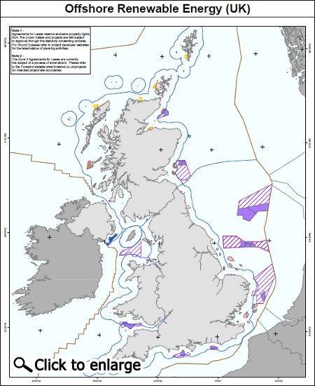
Following the publication of the UK Offshore Energy Strategic Environmental Assessment (SEA) in January 2009, The Crown Estate identified 9 offshore "Round 3" wind farm zones of varying sizes within UK waters to deliver the capacity identified in the SEA.
Renewable energy developers were asked to bid for exclusive rights to develop offshore wind farms within the Round 3 zones. Each Round 3 Zone will be developed differently, with some developers opting to develop the zone in stages, with multiple projects in each zone, and others focussing on a single project.
The developers of the various Round 3 zones are now undertaking environmental and engineering studies as well as liaising closely with stakeholders to define individual projects within the zones. Construction of the first Round 3 project is expected to start in the middle of this decade.
The links in the table below will take you to the developers' websites for detailed information about the wind farms. By clicking on the links in the "stage of project" column below, you will be directed to the project page on the National Infrastructure Planning or Marine Scotland website.
Has the RYA been involved in the Round 3 projects?
The RYA was heavily involved in the initial consultation process surrounding the selection of the nine Round 3 development zones that now exist. While some sites are located in areas with relatively low recreational boating use, the RYA objected to several of the sites during the early stages for navigational safety reasons.
Whilst the RYA may have concerns about the locations of some of the Round 3 zones, the development of renewable energy installations was a core policy for the previous Government and the current Government continues to regard renewable energy as a key theme for its tenure. In addition, given that leases have now been granted by The Crown Estate, there is no realistic prospect of varying the areas already allotted for offshore wind farm development. Since the zones were allocated in 2010, our focus has been on limiting the interference with the ports and shipping industry and on yachting and maritime safety of navigation and tourism.
As with each wind farm development over the past 13 years, the RYA has been contacted by each Round 3 developer, been involved in the consultation process to date and been invited to both private and public meetings to discuss recreational navigational safety.
It can be assumed at this stage that due to the advances in technology the turbine towers will be larger in size and fewer in number compared with those found in the Round 1 and 2 sites. This will mean the turbines will be more widely spaced and, so far, the RYA has been successful in discussions to maintain access through the sites for passage-making by recreational craft.
The RYA will continue to represent all forms of recreational boating and is recognised by all Round 3 developers as the representative body for the recreational boating sector. As such, it is our intention to continue to negotiate directly with all the Round 3 developers, DECC and the Planning Inspectorate as appropriate, and in liaison with our habitual lobbying allies, in order to protect as far as possible the interests of recreational boating.
What are the RYA concerns for specific Round 3 wind farms and how can you make your views heard?
In addition to making developers aware of general navigational safety issues associated with offshore structures, the RYA also raises issues related to specific wind farm developments with their respective developers. However, our response can be strengthened by local responses from members, clubs and training centres.
This is especially true during the community consultation phase of the pre-application work undertaken by developers. Responding to the developers' pre-application consultation is the best time to influence a project, whether you agree with it, disagree with it or believe it could be improved. The developer has to set out how he will consult the public in a Statement of Community Consultation. It is extremely important that the local community engages with the consultation process both during this stage and later when the application is formally submitted to The Planning Inspectorate or Marine Scotland. You can find out more information on the developers' websites using the links in the Round 3 sites and developers websites tab.
We will be adding more specific information below as the various Round 3 proposed developments progress:
West Isle of Wight: Navitus Bay
The third round of public consultation by Navitus Bay Development Ltd closed on 5 April 2013 and the RYA responded once again raising various navigational safety issues.
If you have any queries relating to the Navitus Bay wind farm it is best to e-mail Navitus Bay Development Ltd or call the project team on 0800 008 6763 (Monday - Friday, 9am - 5.30pm). You can also find out more on the Navitus Bay website.
Further information and our concerns about Navitus Bay
Navitus Bay Wind Park is still in the planning infrastructure pre-application phase. The Navitus Bay Statement of Community Consultation gives information about when you can input into the various stages of consultation for this project.
The comments that follow are in relation to the second edition of the Preliminary Environmental Information (PEI2) which is available by registering on the Navitus Bay website.
It is proposed that the export cable will come ashore at Taddiford Gap between Barton on Sea and Milford on Sea. The RYA has made it clear that the export cable is a cause for concern and it will be seeking assurances that it will not pose a threat of underwater collision. This is best avoided by burying cables to maintain charted depth particularly inshore, which is a popular area for all forms of recreational boating and passage making routes to and from the Solent. Further, if some form of cable protection is required elsewhere along the cable corridor, the RYA would expect a minimum underwater clearance of 4m below Chart Datum to be maintained.
PEI2 makes no mention of an application of a safety zone for the operational phase of the wind farm. If the developer subsequently declares that he intends to apply to the Secretary of State for an operational safety zone, the RYA will oppose it unless there is compelling evidence of need supported by a Navigational Risk Assessment. Furthermore the developer must provide an effective and appropriate means for them to notify, and to provide evidence of infringement of safety zones, particularly as infringement creates a criminal offence.
The RYA is particularly concerned that the project area interferes with clear line of sight of the Hurst sectored light for commercial traffic approaching from the west because of the cocked-hat northern boundary. This will increase navigational risk to recreational craft, if commercial traffic routing moves further north into traditional recreational routes on its way to the western Solent in order to acquire the Hurst sectored light.
In December 2012, Navitus Bay Development Ltd announced changes to the boundary of the proposed site; these included reducing the overall size of the proposed site, moving the boundary further away from the shore and a reduction in the maximum number of turbines. This chart shows the latest boundary of the proposed site. For further information read the RYA news article discussing these changes.