Australian Weather
National Summary
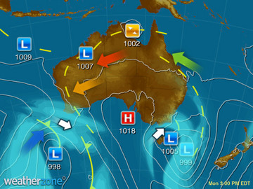
A series of low pressure systems and troughs are triggering thunderstorms over tropical QLD, the upper NT and WA. A trough and onshore winds over northeastern NSW and southern QLD are bringing rain and storms. A trough is drawing a hot airmass over central/southern parts of WA.
Weather News
Biggest rain since last winter soaking NSW coast
15:26 EDT
Parts of the New South Wales coast are in for their biggest downpours since last winter, bringing a much needed drink to gardens and parks but also causing some flooding.
Adelaide to welcome autumn with heatwave
13:05 EDT
After a respite from intense summer heat over the last couple of weeks, Adelaide is set to sizzle once again.
Warmer seas give east coast rain a helping hand
15:19 EDT
If you wanted to stay a bit warmer today, a dip in the ocean is probably your best bet, despite the rain.
Extremes and Records
| Current Extremes | Last 3 Days Extremes | Extremes This Month | |||
|---|---|---|---|---|---|
| Fri 24/02 | Sat 25/02 | Sun 26/02 | |||
|
30.6°C Cannington, Qld |
Hottest |
42.8°C Port Hedland Ap, WA |
42.2°C Port Hedland Ap, WA |
42.0°C Windorah, Qld |
48.7°C Yeelirrie, WA |
|
4.2°C Butlers Gorge, Tas |
Coldest |
-0.6°C Butlers Gorge, Tas |
0.5°C Butlers Gorge, Tas |
3.0°C Lake Leake, Tas |
-2.7°C Thredbo Top Station, NSW/ACT |
|
ENE 53km/h Cape Grim, Tas |
Windiest |
75km/h Solomon Ap, WA |
77km/h Maningrida Ap, NT |
105km/h Ben Nevis, Vic |
- |
|
0.2mm last hr Point Stuart, NT |
Wettest |
170.2mm Innisfail, Qld |
105.4mm Shellharbour, NSW/ACT |
30.0mm Mt Seaview, NSW/ACT |
30.0mm Mt Seaview, NSW/ACT |
| Australia's Records for February | |||
|---|---|---|---|
| Max | Min | Rain | |
| Highest 50.5°C at Mardie, WA in 1998 Lowest -2.7°C at Mt Wellington, Tas in 1994 |
Highest 35.0°C at Moomba Ap, SA in 2004 Lowest -7.4°C at Mt Wellington, Tas in 1994 |
Highest 907.0mm at Crohamhurst, Qld in 1893 |
|


