Australian Weather
National Summary
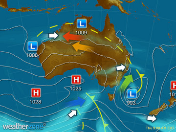
A broad region of low pressure in the tropics is generating squally showers and storms. Another trough over the NT, QLD and NSW is producing storms, some severe. A cold front crossing TAS is bringing showers. A trough over WA is triggering showers and storms.
Weather News
Severe storms to continue mid-week
16:52 EDT
More severe thunderstorms will develop over parts of NSW and Queensland on Wednesday.
Grain growers 'saved by the bell' to see phenomenal cropping season
15:52 EDT
Huge cereal and pulse yields almost never happened in Victoria's north west with a phenomenal year only coming at the last minute.
WA cyclone: Heavy rains, flooding risk in lead up to Christmas in state's north
15:27 EDT
Western Australia's north is facing the threat of heavy rain and flash flooding in the lead-up to Christmas, as two tropical lows hovering off the coast may turn into low-level cyclones.
Extremes and Records
| Current Extremes | Last 3 Days Extremes | Extremes This Month | |||
|---|---|---|---|---|---|
| Sat 17/12 | Sun 18/12 | Mon 19/12 | |||
|
39.8°C Marble Bar, WA |
Hottest |
44.7°C Rabbit Flat, NT |
45.4°C Marble Bar, WA |
45.7°C Onslow Ap, WA |
46.9°C Birdsville Ap, Qld |
|
2.9°C Mt Wellington, Tas |
Coldest |
-3.7°C Mt Hotham, Vic |
-1.7°C Mt Wellington, Tas |
3.2°C Mt Read, Tas |
-3.7°C Mt Hotham, Vic |
|
NNW 75km/h Maatsuyker Is, Tas |
Windiest |
120km/h Wilsons Promontory, Vic |
100km/h Amberley, Qld |
112km/h Mt Hotham, Vic |
- |
|
0.4mm last hr Cape Fourcroy, NT |
Wettest |
127.0mm Wongalara, NT |
120.0mm Shoal Bay, NT |
84.0mm Marion Downs, WA |
132.0mm Channel Point, NT |
| Australia's Records for December | |||
|---|---|---|---|
| Max | Min | Rain | |
| Highest 49.5°C at Birdsville Police Station, Qld in 1972 Lowest -0.8°C at Mt Buller, Vic in 2006 |
Highest 35.0°C at Marble Bar, WA in 1902 Lowest -9.6°C at Cooma Ap, NSW/ACT in 1990 |
Highest 711.0mm at Munglinup West, WA in 2010 |
|


