Australian Weather
National Summary
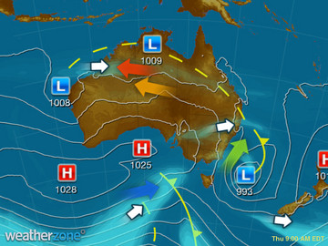
A broad region of low pressure in the tropics is generating squally showers and storms. Another trough over the NT, QLD and NSW is producing storms, some severe. A cold front crossing TAS is bringing showers. A trough over WA is triggering showers and storms.
State Weather
Click for state forecasts


National Synoptic
Weather News
Severe storms to continue mid-week
16:52 EDT
More severe thunderstorms will develop over parts of NSW and Queensland on Wednesday.
Grain growers 'saved by the bell' to see phenomenal cropping season
15:52 EDT
Huge cereal and pulse yields almost never happened in Victoria's north west with a phenomenal year only coming at the last minute.
WA cyclone: Heavy rains, flooding risk in lead up to Christmas in state's north
15:27 EDT
Western Australia's north is facing the threat of heavy rain and flash flooding in the lead-up to Christmas, as two tropical lows hovering off the coast may turn into low-level cyclones.


Extremes and Records
| Current Extremes | Last 3 Days Extremes | Extremes This Month | |||
|---|---|---|---|---|---|
| Sat 17/12 | Sun 18/12 | Mon 19/12 | |||
|
39.8°C Marble Bar, WA |
Hottest |
44.7°C Rabbit Flat, NT |
45.4°C Marble Bar, WA |
45.7°C Onslow Ap, WA |
46.9°C Birdsville Ap, Qld |
|
2.9°C Mt Wellington, Tas |
Coldest |
-3.7°C Mt Hotham, Vic |
-1.7°C Mt Wellington, Tas |
3.2°C Mt Read, Tas |
-3.7°C Mt Hotham, Vic |
|
NNW 75km/h Maatsuyker Is, Tas |
Windiest |
120km/h Wilsons Promontory, Vic |
100km/h Amberley, Qld |
112km/h Mt Hotham, Vic |
- |
|
0.4mm last hr Cape Fourcroy, NT |
Wettest |
127.0mm Wongalara, NT |
120.0mm Shoal Bay, NT |
84.0mm Marion Downs, WA |
132.0mm Channel Point, NT |
| Australia's Records for December | |||
|---|---|---|---|
| Max | Min | Rain | |
| Highest 49.5°C at Birdsville Police Station, Qld in 1972 Lowest -0.8°C at Mt Buller, Vic in 2006 |
Highest 35.0°C at Marble Bar, WA in 1902 Lowest -9.6°C at Cooma Ap, NSW/ACT in 1990 |
Highest 711.0mm at Munglinup West, WA in 2010 |
|
Christmas Day Weather Forecast
-
Display your Local Weather here
automatically each time you visit us:

Rotates through Temperature,
Wind, Humidity and RainUse the Search Bar above
to find your Local, and go to the Local page
Click "Set My Local"
button next to the location name