Australian Weather
National Summary
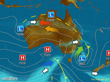
A trough is generating showers and storms over southern NT and SA, while drawing in heat to western parts of QLD and NSW. A region of low pressure is triggering showers and the odd storm over the Top End and northern WA. Onshore winds are bringing showers to coastal QLD.
Weather News
Late-spring heat gripping NSW
14:59 EDT
New South Wales is baking today as temperatures soar more than 10 degrees above average in some areas.
Double heat for Sydney
19:26 EDT
Two rounds of hot weather during the next week will pack out beaches and pools across the Sydney Basin.
Central Melbourne gets a tree change in readiness for hotter climate
19:09 EDT
Central Melbourne's streetscape is set for a marked change over the decades to come.
Extremes and Records
| Current Extremes | Last 3 Days Extremes | Extremes This Month | |||
|---|---|---|---|---|---|
| Wed 16/11 | Thu 17/11 | Fri 18/11 | |||
|
30.8°C Broome Ntc, WA |
Hottest |
44.0°C Eyre, WA |
42.0°C Wyndham Ap, WA |
39.0°C Moomba Ap, SA |
46.0°C West Roebuck, WA |
|
3.5°C Mt Wellington, Tas |
Coldest |
0.3°C Perisher Valley, NSW/ACT |
1.2°C Mt Wellington, Tas |
-5.5°C Mt Hotham, Vic |
|
|
WSW 57km/h Mt Hartz, Tas |
Windiest |
77km/h Forrest, WA |
137km/h Maatsuyker Is, Tas |
98km/h Maatsuyker Is, Tas |
- |
| no rain last hr | Wettest |
38.8mm Point Stuart, NT |
68.8mm Middle Point, NT |
0.2mm Low Rocky Point, Tas |
543.8mm Orbost, Vic |
| Australia's Records for November | |||
|---|---|---|---|
| Max | Min | Rain | |
| Highest 48.7°C at Birdsville Police Station, Qld in 1990 Lowest -3.1°C at Thredbo Top Station, NSW/ACT in 1967 |
Highest 35.0°C at Cunnamulla, Qld in 1965 Lowest -20.6°C at Mt Hotham, Vic in 1990 |
Highest 398.8mm at Moreton, Qld in 1909 |
|


