 language
 Basque
 Bulgarian
 Catalan
 Czech
Czech Danish
 Dutch
Dutch Estonian
 Finnish
 French
 Galician
 German
 Hungarian
 Italian
 Latvian
 Lithuanian
 Polish
 Portuguese
 Romanian
 Russian
 Spanish
 Swedish
 Turkish
Weather models used by Windguru
GFS model
GFS stands for the Global Forecast System. It is run by National Centers for Environmental Prediction (NCEP) which is a unit of NOAA (National Oceanic and Atmospheric Administration), NWS (National Weather Service), USA. The GFS is run four times per day (00 UTC, 06 UTC, 12 UTC, and 18 UTC) out to 384 hours. GFS is a global model so it cover all the Earth! Since January 2015 GFS produce forecasts with resolution of 27 km out to 240 hours.
NAM model
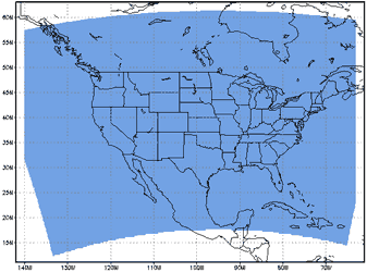
The North American Mesoscale (NAM) is a regional mesoscale model using enhanced terrain and improved parameterization of surface and precipitation processes. It is also run by NCEP, formerly it's name was Eta, but in early 2005 it was renamed to NAM. Windguru uses 84 hour forecast data in 3 hour step which covers Northern America with average resolution of 0.11 degree (about 12 km). Updates four times per day. Much higher resolution than GFS should give more precise short term forecasts. Coverage map:
NAM 12 km |
 |
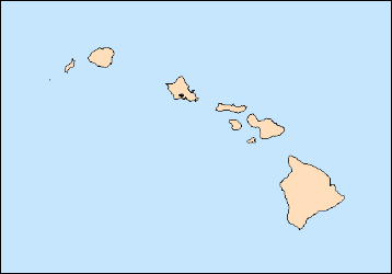
Since October 2011 NOAA/NCEP added several high resolution subdomains to their NAM model. The first we use on windguru is the one that covers Hawaii in 3 km resolution. The subdomains run inside the main 12 km domain from 0 to 60 h, but at the moment we only show the first 36 hour forecast, the reason for this is that for 0-36h the output files are available in 1 hour steps, but 36-60h only in 3 hour steps, and it is not so easy to combine that in the current windguru forecast tables (at least now, it will probably change in future). Updates are 4 times per day.
NAM 3 km |
 |
WRF model
The Weather Research and Forecasting (WRF) Model is a next-generation mesocale numerical weather prediction system designed to serve both operational forecasting and atmospheric research needs. It is an evolutionary successor to the MM5 model. The effort to develop WRF has been a collaborative partnership, principally among the National Center for Atmospheric Research (NCAR), the National Oceanic and Atmospheric Administration (the National Centers for Environmental Prediction (NCEP) and the Forecast Systems Laboratory (FSL), the Air Force Weather Agency (AFWA), the Naval Research Laboratory, Oklahoma University, and the Federal Aviation Administration (FAA). More info at the WRF model website.
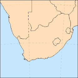
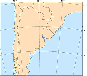
We are running WRF model for most Europe and Mediterranean. Canary Islands, Madeira and part of Morocco's Atlantic coast are also covered by WRF with 9 km resolution. Another smaller WRF 9 km resolution domain covers Northern Red Sea with popular spots in Egypt, and also Israel, Lebannon and south of Cyprus. We also provide WRF 9 km forecasts for East Asia, this domain covers Japan, Korea, Taiwan and east China. Argentina, Chile and Uruguay are covered by WRF 12 km. The initial and boundary conditions come from GFS. If everything goes smooth WRF updates 4 times per day and produce forecast for 78 hours to the future in 1 hour step. Forecasts include wind speed and direction, wind gusts, temperature, total cloud cover and precipitation.
The highest resolution model we are running now is 3 km. Such a high resolution requires massive computing so the covered area can't be very large. WRF with 3 km covers Czech republic, forecasts are for next 48 hours and update 4 times per day. Another small 3 km domain covers one of the most famous areas for wind & kitesurfing in Europe - Tarifa / Strait of Gibraltar.
Area covered by WRF with 27 km resolution: |
Area covered by WRF with 9 km resolution: |
 |
 |
WRF with 3 km resolution: (Czech rep.) |
WRF with 3 km resolution: (Gibraltar) |
 |
 |
WRF with 9 km resolution: (Canary) |
WRF with 9 km resolution: (Egypt) |
 |
 |
WRF with 9 km resolution: (South Africa) |
WRF with 9 km resolution: (East Asia) |
 |
 |
WRF with 12 km resolution: (Argentina) |
|
 |
HRW model
The HRW (High Resolution Window) is WRF powered forecast model, it is run by American NOAA/NCEP same like GFS and NAM models described above. We use forecast data which cover Hawaiian islands with 5 km horizontal resolution and United States with 4 km resolution. Forecast length is 48 hours. Forecasts for Hawaii and US east update twice per day (model cycles 00 UTC and 12 UTC) and forecasts for US west update once per day (model cycle 06 UTC). Another smaller HRW 5 km domain covers part of Caribbean around Dominican republic and Puerto Rico and updates twice per day (cycles 06 UTC and 18 UTC).
As you can see on the maps below, the US east and US west domain overlap quite a lot, so if you view forecast for spot somewhere in the central US which is covered by both HRW domains you will always see the latest available model forecast - either from HRWe or HRWw depending on which one is the most up-to-date. So we can say that for central US the HRW model updates 3 times per day (00,06 and 12 UTC cycles)
Notice: Some or all HRW forecasts will not update if NOAA needs to run Hurricane models instead.
HRW forecasts are free to all users!
HRWw with 4 km resolution: |
HRWe with 4 km resolution: |
 |
 |
HRW with 5 km resolution: |
HRW with 5 km resolution: |
 |
 |
Current model data:
| GFS 27 km (world): | 12.11.2015 12 UTC |
| NWW3 (waves): | 12.11.2015 12 UTC |
| WRF 27 km (Europe): | 12.11.2015 12 UTC |
| WRF 9 km (Europe): | 12.11.2015 12 UTC |
| WRF 9 km (Canary): | 12.11.2015 12 UTC |
| WRF 9 km (Egypt): | 12.11.2015 12 UTC |
| WRF 9 km (South Africa): | 12.11.2015 12 UTC |
| WRF 9 km (East Asia): | 12.11.2015 12 UTC |
| WRF 12 km (Argentina): | 12.11.2015 12 UTC |
| WRF 3 km (CZ): | 12.11.2015 12 UTC |
| WRF 3 km (Gibraltar): | 12.11.2015 12 UTC |
| NAM 12 km (N.America): | 12.11.2015 18 UTC |
| NAM 3 km (Hawaii): | 12.11.2015 18 UTC |
| HRW 5 km (Hawaii): | 12.11.2015 12 UTC |
| HRW 5 km (Caribbean): | 12.11.2015 06 UTC |
| HRW 4 km (US): | 12.11.2015 12 UTC |
Model update schedule:
| model cycle: | 00 UTC | 06 UTC | 12 UTC | 18 UTC | |
| GFS 27 km (world) | 05:05 UTC | 11:05 UTC | 17:05 UTC | 23:05 UTC | |
| NWW3 (waves) | 04:55 UTC | 10:55 UTC | 16:55 UTC | 22:55 UTC | |
| WRF 27 km (Europe) | 05:30 UTC | 11:30 UTC | 17:30 UTC | 23:30 UTC | |
| WRF 9 km (Europe) | 08:00 UTC | 14:00 UTC | 20:00 UTC | 02:00 UTC | |
| WRF 9 km (Canary) | 08:10 UTC | 14:10 UTC | 20:10 UTC | 02:10 UTC | |
| WRF 9 km (Egypt) | 07:35 UTC | 13:35 UTC | 19:35 UTC | 01:35 UTC | |
| WRF 9 km (South Africa) | 07:10 UTC | 13:10 UTC | 19:10 UTC | 01:10 UTC | |
| WRF 9 km (East Asia) | 08:25 UTC | 14:25 UTC | 20:25 UTC | 02:25 UTC | |
| WRF 12 km (Argentina) | 08:30 UTC | 14:30 UTC | 20:30 UTC | 02:30 UTC | |
| WRF 3 km (CZ) | 08:00 UTC | 14:00 UTC | 20:00 UTC | 02:00 UTC | |
| WRF 3 km (Gibraltar) | 08:20 UTC | 14:20 UTC | 20:20 UTC | 02:20 UTC | |
| NAM 12 km (N.America) | 03:00 UTC | 09:00 UTC | 15:00 UTC | 21:00 UTC | |
| NAM 3 km (Hawaii) | 02:15 UTC | 08:15 UTC | 14:15 UTC | 20:15 UTC | |
| HRW 5 km (Hawaii) | 04:50 UTC | 16:50 UTC | |||
| HRW 5 km (Caribbean) | 10:50 UTC | 22:50 UTC | |||
| HRW 4 km (US) | 05:45 UTC | 17:45 UTC |
(Approximate model update times in UTC, current time is 12.11.2015 21:02 UTC)

