
PEIN Country Profile and Virtual Environment Library
 Guam
Guam
Capital City: 
Hagatna
Languages
National Focal Points for Environment:
Environmental Protection Agency
Overview
Excerpts from Wikipedia
Geography
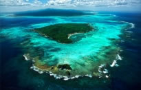
Guam lies between 13.2°N and 13.7°N and between 144.6°E and 145.0°E, and has an area of 209 square miles (541 km2), making it the 32nd largest island of the United States. It is the southernmost island in the Mariana island chain and is the largest island in Micronesia. This island chain was created by the colliding Pacific and Philippine tectonic plates. The Mariana Trench, a deep subduction zone, lies beside the island chain to the east. Challenger Deep, the deepest surveyed point in the Oceans, is southwest of Guam at 35,797 feet (10,911 m) deep. The highest point in Guam is Mount Lamlam, which is 1,332 feet (406 m). The island of Guam is 30 miles (48 km) long and 4 mi (6 km) to 12 mi (19 km) wide. The island experiences occasional earthquakes due to its location on the western edge of the Pacific Plate and near the Philippine Plate. In recent years, earthquakes with epicenters near Guam have had magnitudes ranging from 5.0 to 8.7. Unlike the Anatahan volcano in the Northern Mariana Islands, Guam is not volcanically active.[6] However, due to its proximity to Anatahan, vog does occasionally affect Guam.[7]
The northern part of the island is a forested coralline limestone plateau while the south contains volcanic peaks covered in forest and grassland. A coral reef surrounds most of the island, except in areas where bays exist that provide access to small rivers and streams that run down from the hills into the Pacific Ocean and Philippine Sea.[8] The island's population is most dense in the northern and central regions.[5]
Climate
The climate is characterized as tropical marine. The weather is generally hot and very humid with little seasonal temperature variation. The mean high temperature is 86 °F (30 °C) and mean low is 76 °F (24 °C) with an average annual rainfall of 96 inches (2,180 mm). The dry season runs from December through June. The remaining months constitute the rainy season. The months of January and February are considered the coolest months of the year with night time temperatures in the mid to low 70's and generally lower humidity levels. The highest risk of typhoons is during October and November. They can occur, however, year-round.
An average of three tropical storms and one typhoon pass within 180 nautical miles (210 mi; 330 km) of Guam each year. The most intense typhoon to pass over Guam recently was Super Typhoon Pongsona, with sustained winds of 125 miles per hour, which slammed Guam on December 8, 2002, leaving massive destruction.
Since Super Typhoon Pamela in 1976 wooden structures have been largely replaced by concrete structures.[9][10] During the 1980s wooden utility poles began to be replaced by typhoon-resistant concrete and steel poles. After the local Government enforced stricter construction codes, many home and business owners built their structures out of reinforced concrete with installed typhoon shutters.
Ecological issues
Guam exemplifies the effects of bioinvasion.
The brown tree snake
Thought to be a stowaway on a U.S. military transport near the end of World War II, the brown tree snake (Boiga irregularis) came to Guam and killed virtually all of the native bird population on an island that has no native species of snake; this snake has no natural predators on the island. While slightly venomous, the brown tree snake is relatively harmless to human beings. Although some studies have suggested a high density of the brown tree snake, residents rarely see these nocturnal snakes. Prodigious climbers, the snakes cause frequent blackouts by shorting across lines and transformers. The Guam Customs & Quarantine Agency is training detector dogs to seek out Brown Tree Snakes throughout inland Guam in an effort to further mitigate and reduce their escalating population. [15][16]
Coconut Rhinoceros Beetle
An infestation of the coconut rhinoceros beetle (CRB), Oryctes rhinoceros, was detected on Guam on September 12, 2007. CRB is not known to occur in the United States except in American Samoa. Delimiting surveys performed September 13-25, 2007 indicated that the infestation was limited to Tumon Bay and Faifai Beach, an area of approximately 900 acres (3.6 km2). Guam Department of Agriculture (GDA) placed quarantine on all properties within the Tumon area on October 5 and later expanded the quarantine to about 2,500 acres (10 km2) on October 25; approximately 0.5 miles (800 m) radius in all directions from all known locations of CRB infestation. CRB is native to Southern Asia and distributed throughout Asia and the Western Pacific including Sri Lanka, Upolu, Western Samoa, American Samoa, Palau Islands, New Britain, West Irian, New Ireland, Pak Island and Manus Island (New Guinea), Fiji, Cocos (Keeling) Islands, Mauritius, and Reunion.
Adults are the injurious stage of the insect. They are generally night-time fliers and when they alight on a host, they chew down into the folded, emerging fronds of coconut palms to feed on sap. V-shaped cuts in the fronds and holes through the midrib are visible when the leaves grow out and unfold. If the growing tip is injured, the palm may be killed or severe loss of leaf tissue may cause decreased nut set. Feeding wounds may also serve as an infection pathway for pathogens or other pests. The effects of adult boring may be more severe on younger palms where spears are narrower. Mortality of young palms has already been observed on Guam. Oviposition and larval development typically occurs in decaying coconut logs or stumps.
Control measures have been developed for CRB and the current strategy on Guam is to implement an integrated eradication program using pheromone-baited, attractive traps to capture adults, various methods to eliminate infested and susceptible host material, and pesticides to kill larvae and adults. Pesticides may also be applied to uninfested trees as a preventive treatment. USDA-APHIS has completed an Environmental Assessment for the coconut rhinoceros beetle eradication program on Guam (EA Number: GU-08-1, http://www.guaminsects.net/uogces/kbwiki/images/d/dc/CRB_EA.pdf). The eradication program is a cooperative effort between USDA (APHIS and Forest Service), GDA and the University of Guam (UOG). This document follows the Forest Service Pest Risk Assessment (Kliejunas et al. 2001)format and is intended to provide information regarding the current status of CRB on Guam, its potential to spread to uninfested locales, and the consequences of establishment. The high, moderate or low risk values are based on available biological information and the subjective judgment of the authors.
Other invasive species
From the seventeenth through nineteenth centuries, the Spanish introduced pigs, dogs, chickens, the Philippine deer (Cervus mariannus), black francolins, and water buffalo. Water buffalo, known as carabao locally, have cultural significance. Herds of these animals obstruct military base operations and harm native ecosystems. After birth control and adoption efforts were ineffective, the U.S. military began euthanizing the herds in 2002 leading to organized protests from island residents.[17]
Other introduced species include cane toads imported in 1937, the giant African snail (an agricultural pest introduced during WWII by Japanese occupation troops) and more recently frog species which could threaten crops in addition to providing additional food for the brown tree snake population. Reports of loud chirping frogs native to the Caribbean and known as coquí, that may have arrived from Hawaii, have led to fears that the noise could threaten Guam's tourism.[18]
Introduced feral pigs and deer, over-hunting, and habitat loss from human development are also major factors in the decline and loss of Guam's native plants and animals.
Threats to indigenous plants
Invading animal species are not the only threat to Guam's native flora. Tinangaja, a virus affecting coconut palms, was first observed on the island in 1917 when copra production was still a major part of Guam's economy. Though coconut plantations no longer exist on the island, the dead and infected trees that have resulted from the epidemic are seen throughout the forests of Guam.[19] Also during the past century, the dense forests of northern Guam have been largely replaced by thick tangan tangan brush (Leucaena-native to the Americas). Much of Guam's foliage was lost during World War II. In 1947, the U.S. military introduced tangan tangan by seeding the island from the air to prevent erosion. In southern Guam, non-native grass species also dominate much of the landscape.
Wildfires
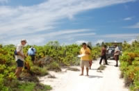
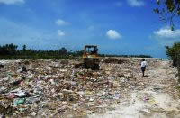
Wildfires plague the forested ("boonie" or "jungle") areas of Guam every dry season despite the island's humid climate. Most fires are man-caused with 80 percent resulting from arson.[20] Poachers often start fires to attract deer to the new growth. Invasive grass species that rely on fire as part of their natural life cycle grow in many regularly burned areas. Grasslands and "barrens" have replaced previously forested areas leading to greater soil erosion. During the rainy season sediment is carried by the heavy rains into the Fena Lake Reservoir and Ugum River leading to water quality problems for southern Guam. Eroded silt also destroys the marine life in reefs around the island. Soil stabilization efforts by volunteers and forestry workers to plant trees have had little success in preserving natural habitats.[21]
Aquatic preserves
As a vacation spot for scuba divers, efforts have been made to protect Guam's coral reef habitats from pollution, eroded silt, and overfishing that have led to decreased fish populations. In recent years the Department of Agriculture, Division of Aquatic and Wildlife Resources has established several new marine preserves where fish populations are monitored by biologists.[22] Prior to adopting U.S. Environmental Protection Agency? standards, portions of Tumon bay were dredged by the hotel chains in order to provide a better experience for hotel guests.[23][24] Tumon Bay has since been made into a preserve. A federal Guam National Wildlife Refuge in northern Guam protects the decimated sea turtle population in addition to a small colony of Mariana fruit bats.[25]
Country Profiles
Country Reports
Technical Reports
Country Websites
Country Profiles
Birdlife [Avifauna] Profiles
see also Species profiles [*For the Globally Threatened Birds (those evaluated as Critically Endangered, Endangered and Vulnerable), each factsheet contains a summary account, range map and an illustration, plus additional data tables. For Extinct, Extinct in the Wild, Near Threatened, Least Concern and Data Deficient species, each contains a concise summary paragraph and some additional data tables.] [Birdlife International]
Guam
see also Endemic Bird Areas [EBAs] of the Pacific [incl. Aitutaki (secondary area) ; East Caroline Islands ; Fiji ; Gilbert Islands (secondary area) ; Henderson Island ; Mariana Islands ; Marquesas Islands ; Marshall Islands (secondary area) ; Nauru (secondary area) ; Niuafo'ou (secondary area) ; Niue (secondary area) ; Northern Line Islands (secondary area) ; Palau ; Pitcairn (secondary area) ; Rapa (secondary area) ; Rimatara ; Rotuma (secondary area) ; Samoan Islands ; Society Islands ; Southern Cook Islands ; Tonga (secondary area) ; Tuamotu archipelago ; Wake Island (secondary area) ; Wallis and Futuna (secondary area) ; Yap Islands ] [Birdlife International]
see alsoImportant bird areas of the Pacific [IBAs] (2010) [Birdlife Pacific]
IBA Profiles:
IBA Reports:
* order the complete CD-ROM 'Important bird areas in the Pacific: a compendium' from the SPREP IRC
see also Pacific regional overview [Birdlife International]
see also State of the World's birds website and report [Birdlife International] - including Pacific country case studies
Earthtrends Thematic Country Profiles [WRI]
Agriculture and food, Biodiversity and protected areas, Climate and atmosphere, Coastal and marine ecosystems, Economics, business and the environment, Energy and resources, Environmental governance and institutions, Forests, grasslands and drylands, Population, health and human well-being, Water resources and freshwater ecosystems.
Ecoregion Profiles [World Wildlife Fund]
Tropical & Subtropical Dry Broadleaf Forests
Marianas [Northern Mariana Islands, Guam]
Environment Statistics - Country Snapshots [UN; 2009]
Forestry Country Profiles
Mongabay Rainforest profiles:
Invasive Species : Country Profiles [ISSG]
see NBII Invasive Species information Node profiles
Laws and legislation
SPREP National Laws and Legislation clearinghouse
Mangrove and Wetlands Profiles
see : Wetlands of the Pacific Island Region (2008; 882kb)
see also: IWMI Global Wetlands - Interactive Web Map Server - includes countries of Oceania
see also: Wetlands in Oceania - country profiles and wetlands information [UNEP-WCMC] - Guam
Marine Resource Profiles
State of Coral Reef Systems
Guam (2005; 1.52mb) , Guam (2008; 2.74mb)
see also:
see also:
State of the marine environment in the South Pacific Region (1990; 3.48mb)
see also:
see also GIS data for corals in the Pacific from Reefbase - browse by country and reef profile
see also GIS data for marine protected areas in the Pacific from Reefbase - browse by country and ecosystem
see also:
NOAA's Coral Reef Information System - Pacific profiles
see also:
Marine Resources Assessment for the Marianas Operating Area (2005; 15.28mb)
Pacific Regional information System - PRISM [SPC]
Environmental and Climate Statistics
Political Reviews [Contemporary Pacific]
Guam
Protected Areas
Protected Planet - Search the World Database on Protected Areas
Protected area profiles in Guam
Reefbase GIS data for marine protected areas in Guamsee also GIS data for marine protected areas in the Pacific - browse by country and ecosystem
SocMon profiles (Socioeconomic Monitoring Initiative for Coastal Management ) - Pacific
SPREP Country Profiles: Exchange of Information by Members at SPREP Annual Meetings:
- Exchamge of information by Members on National Developments related to Natural Resource Management Priority of the Action Plan [2007]
see Agenda Item 6.1: Country Profiles of the Report and record of the 18th SPREP Meeting of Officials in Apia, Samoa on 11th to 14th September 2007
- Exchange of information by Members on national developments related to Pollution Prevention priority of the SPREP Action Plan [2008]
see Agenda Item 8.6: Country Profiles of the Report and record of the19th SPREP Annual Meeting of Officials in Pohnpei, Federated States of Micronesia on 8–12 September 2008
- Exchange of Information by Members on National Developments Related to the Climate Change Focus Area of the SPREP Action Plan [2009]
see Agenda Item 11.2: Country Profiles of the Report and record of the 20th SPREP Annual Meeting of Officials in Apia, Samoa on 17 - 20 November 2009
- Exchange of Information by Members on Year of Biodiversity [2010]
see Agenda Item 11.3: Country Profiles of the Report and record of the 21st SPREP Meeting of Officials in Madang, Papua New Guinea on 6-10 September 2010
see also individual profiles for: Wallis and Futuna
Threatened species: Summary of species on the 2008 IUCN Red List
UNEP Country Profiles [* poorly maintained and little information available]
Guam
Water Data Country Profiles [USGS]
Guam
World Factbook Country Profiles [CIA]
Guam
World Ocean Database 2005 [NOAA]
Geographically sorted data for the Pacific Ocean [datasets]
see also Environmental indicators: South Pacific (UNEP: 2004; 6.23mb)
see also Polynesia / Micronesia Biodiversity Hotspot Ecosystem Profile (2007; 1.16mb)
see also Paciifc Biodiversity Information Forum website and databasesRead more
Country Reports
Guam (2008; 5.67mb)
Fishery ecosystem plan for the Mariana Archipelago [WPRFMC] (2005; 2.31mb)
Mariana Islands Range Complex: Environmental Impact Statement
Volume 1 (37.5mb) ; Volume 2 (9.2mb)
Marine Resources Assessment for the Marianas Operating Area (2005; 15.28mb)
Ships' Waste Management in Pacific Islands Ports: Country reports
State of the Environment Reports
see the archive of SPREP Country Reports between 1980-1983 as follows:
Guam [Fr] (1980; 4.93mb)Read more
Country Websites
Guam Environmental Protection Agency
Guam Meteorological Office
Island Research and Education Initiative
Island Research & Educational Initiative (IREI) is a not-for-profit, non-governmental organization committed to upholding the unique environmental and cultural legacies of islands and island peoples. We initiate and implement our own projects and collaborate with like-minded groups. The scientific and educational work by IREI is carried out in direct response to specific concerns in specific locales.
The Marine Laboratory [Univ. of Guam]
The Marine Laboratory serves the greater Micronesian region, including the Territory of Guam, the Commonwealth of the Northern Mariana Islands, the Federated States of Micronesia (Yap, Chuuk, Kosrae and Pohnpei), the Republic of Palau and the Republic of the Marshall Islands. The lab's mission is to perform basic and applied research on the biology of tropical marine organisms, emphasising conservation and management of coastal marine resources and to provide community service through environmental assessments, technical reports and educational materials. Includes access to many full text publications.
see also:
SPREP Library and IRC collection [SLIC] - includes online full text access to a wide range of Pacific environment materials.
The Pacific Environment Information Network [PEIN] Virtual Library - full text publications from SPREP, SOPAC, SPC and other CROP agencies, Pacific govt. environment depts. , regional institutions, and NGOs active in the area of environment conservation.
Pacific Environment Databases and Recommended Internet Resources
see also:
SPREP's International Instruments' webpage
"International instruments relevant to SPREP's work in the areas of Sustainable Economic Development, Ecosystems Management, Climate Change, and Waste Management."
http://www.sprep.org/att/IRC/eCOPIES/Birdlife-Pacific/2.%20%20CONTENTS.htm
Academic literature and research
via Google Scholar
Read more


