Australian Weather

National Summary
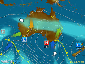
A cold front and trough is bringing powerful winds and showers to VIC, TAS and southeast SA and NSW. Showers are falling as snow over highland areas. A broad high pressure ridge is leading to clear skies elsewhere.
State Weather
Click for state forecasts


National Synoptic
Weather News
Parts of Tasmania turn white as spring cold snap brings snow, freezing conditions
11:29 EST
Tasmanians received a reminder the cold season was not quite over with a cold snap causing snowfalls as low as 100 metres.
Police praise Tasmanian pair rescued after emergency satellite message
16:59 EST
A mother and son stranded by rain and snow near Lake McKenzie in Tasmania's north have been rescued after calling for help by satellite messages.
Climate change increasing the intensity and impact of extreme weather, BOM tells emergency managers
16:45 EST
Cyclones are expected to be less likely in the future due to climate change, though the intensity and impact of extreme weather will be greater, according to a senior climatologist with the Bureau of Meteorology (BOM).


Extremes and Records
| Current Extremes | Last 3 Days Extremes | Extremes This Month | |||
|---|---|---|---|---|---|
| Sat 02/09 | Sun 03/09 | Mon 04/09 | |||
|
34.5°C Oenpelli Airport, NT |
Hottest |
37.6°C Wyndham Ap, WA |
38.0°C Wyndham Ap, WA |
39.0°C Wyndham Ap, WA |
39.0°C Wyndham Ap, WA |
|
-6.4°C Thredbo Top Station, NSW/ACT |
Coldest |
-3.4°C Glen Innes Ap, NSW/ACT |
-5.0°C Mt Hotham, Vic |
-8.0°C Thredbo Top Station, NSW/ACT |
-9.5°C Perisher Valley, NSW/ACT |
|
NW 83km/h Maatsuyker Is, Tas |
Windiest |
140km/h Thredbo Top Station, NSW/ACT |
146km/h Thredbo Top Station, NSW/ACT |
127km/h Hogan Island, Vic |
- |
|
2.6mm last hr Cocos Island Ap, WA |
Wettest |
354.0mm Glenaladale, Vic |
50.8mm Glenaladale, Vic |
32.0mm Wilsons Promontory, Vic |
32.0mm Wilsons Promontory, Vic |
| Australia's Records for September | |||
|---|---|---|---|
| Max | Min | Rain | |
| Highest 43.1°C at West Roebuck, WA in 2003 Lowest -6.2°C at Mt Buller, Vic in 1995 |
Highest 30.0°C at Warmun, WA in 2016 Lowest -16.7°C at Charlotte Pass, NSW/ACT in 1970 |
Highest 370.3mm at Burdekin, Qld in 1890 |
|
-
Display your Local Weather here
automatically each time you visit us:

Rotates through Temperature,
Wind, Humidity and RainUse the Search Bar above
to find your Local, and go to the Local page
Click "Set My Local"
button next to the location name


