


In 1885, Diana acquired a considerable amount of land at Piambong in the Parish of Wiadere as shown on the map below.
Portions 41 and 38 covered 400 acres of land and were acquired as a Conditional Purchase. A Conditional Purchase was a way of obtaining crown land in 1800s: "Selectors could purchase between 40 and 320 acres, paying one quarter of the price as a deposit, occupying and improving the land for three years, and paying the balance over an extended term. This was known as 'conditional purchase'."( Fallon, 2002, p.69) *
The remaining lots, 115 and 12, covered 879 acres.
All of Diana's land was acquired in her name with George Henry Cox as guarantor. The exact nature of this arrangement remain unclear although there are several possibilities.
Cox Family papers and other documentation certainly indicate that the family treated their servants and tenants with kindness and that some of them were assisted in purchasing land and in their own right. This may well have been the case for Diana.
It is also possible that Diana’s name was used as a �?dummy selector’ as was a common practice of the time. Landowners would purchase land in the names of their wives, children or servants as a security. This land would be spared should they lose the land purchased in their own name.
We may never know the exact nature of Diana’s land ownership, but we do know that portions 38, 41, 115, 121 were kept in her name until 1895 when they passed into the ownership of Reginald Belmore Cox, the third son of George Henry Cox.
*Fallon, Sue, 2002, Family History for beginners and beyond, Canberra, Heraldry & Genealogy Society of Canberra Inc.
Diana's neighbours
Shown on the map are Diana's land holdings and those of George Henry Cox, highlighting the connection between Diana and the Cox family. This may provide some clues to the nature of the relationship between the two families. This map also shows the holdings of Diana's husband, son Shadrack and daughter Jane as well as the joint holdings of Diana's partner Robert Rayner and Edward Cover.
Other Rayner holdings remained in the family for much longer. This can be seen in a range of documents including:
- Yewen’s Directory of landholders in NSW, 1900, showing Shadrack Raynor and other members of the Raynor family.
- New South Wales Census - Mudgee district , showing Shadrack Rayner
- The Australian pastoral directory of stockowners in the states of New South Wales, Queensland, Victoria, South Australia, West Australia, Northern Territory and Tasmania, showing Rayner’s in the Piambong area during the years:
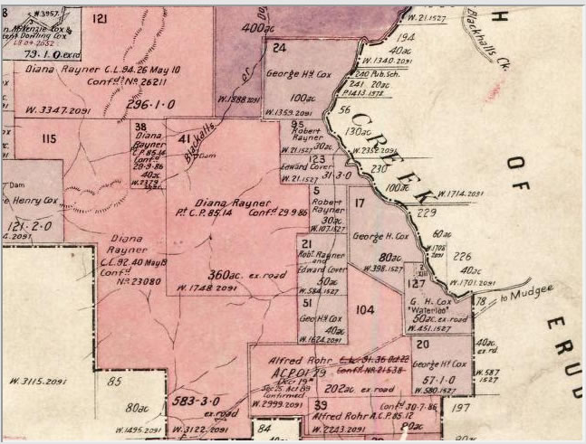
Diana's first parcel of land (lots 115, 41, 121 & 38) totalling1300 acres in the parish of Wadiare, Piambong, NSW.
Source: Cancelled Maps, 1880-1976. SRNSW: CGS 10169 [Map No 1276