
National Synoptic Information
A Synoptic chart is any map or chart that depicts meterological or atmospheric conditions over a larger area at any given time. The charts on this page are drawn from information supplied by Weatherzone.
A Synoptic chart is any map or chart that depicts meterological or atmospheric conditions over a larger area at any given time. The charts on this page are drawn from information supplied by Weatherzone.

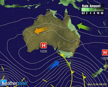
A small low pressure system is driving powerful winds and heavy rain into the Illawarra and South Coast, with light rain drifting into the Riverina and eastern VIC. A pair of troughs are producing showers and storms over QLD and central Australia.

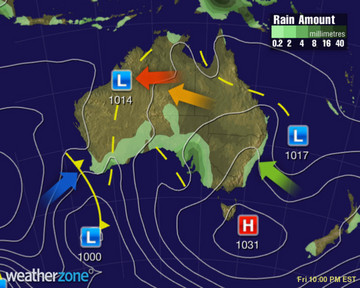
A series of troughs will filter unseasonably warm conditions across QLD and the NT while causing showers and thunderstorms. A low and trough will cause showers and rain across southeast SA, southern NSW and VIC. A ridge of high pressure will bring mostly sunny weather in the west

A low may move over the Tasman Sea and deepen, causing showers and gusty winds across southeast NSW, VIC and eastern TAS. A pair of troughs will cause showers and a few thunderstorms across northern NSW, QLD and the NT. A trough will cause cloud to increase over southwest WA.

A pair of troughs will generate warm conditions and thundery showers across the interior and QLD. A front should produce a few showers in TAS, VIC and southeastern NSW. A trough will cause thundery showers over southwest WA.

A trough over eastern QLD will deepen, generating showers and thunderstorms. A low will move further over the Tasman Sea, easing showers in TAS, eastern VIC and southern NSW. A trough and front over WA will generate showers and thunderstorms.
A trough over QLD will move offshore, causing showers and storms to clear. A low will move further away over the Tasman Sea, allowing showers to mostly clear. A trough and front will generate thundery showers over SA and southwest WA.
A deep trough should cross into SA, producing rain and drawing warm air ahead of it. A front following it will trigger showers in southern WA, whilst bringing cooler air. Ridges of high pressure should keep elsewhere mostly dry, whilst directing a few showers onto NSW north coast


