Australian Weather
National Summary
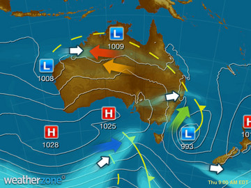
The two main low pressure troughs are triggering the odd shower and storm over central WA and tropical QLD. The weak pressure pattern is keeping heat over central and western parts of Australia as seabreezes and onshore winds keep coastal areas mild.
Weather News
Queensland farmer weathers the storm, literally and financially, during bad weather
09:54 EDT
A Queensland lettuce farmer says having two properties to grow his lettuce on helps to offset the risks of the summer storm season.
Summer opening with a heatwave
17:12 EDT
Summer will turn up right on time for parts of Australia's eastern inland, with a heatwave forecast for some areas in southern Queensland and northern New South Wales.
Eastern storms continue
12:21 EDT
Severe thunderstorms will continue to affect parts of Queensland and New South Wales at the beginning of this week.
Extremes and Records
| Current Extremes | Last 3 Days Extremes | Extremes This Month | |||
|---|---|---|---|---|---|
| Sat 26/11 | Sun 27/11 | Mon 28/11 | |||
|
35.7°C Lajamanu, NT |
Hottest |
42.6°C Marble Bar, WA |
42.8°C Marble Bar, WA |
44.0°C Marble Bar, WA |
46.0°C West Roebuck, WA |
|
4.0°C Mt Wellington, Tas |
Coldest |
-0.6°C Perisher Valley, NSW/ACT |
1.0°C Mortlake, Vic |
0.0°C Perisher Valley, NSW/ACT |
-5.5°C Mt Hotham, Vic |
|
S 38km/h North Island, WA |
Windiest |
96km/h Hogan Island, Vic |
105km/h Dalby Ap, Qld |
81km/h Leinster Ap, WA |
- |
|
0.2mm last hr Cocos Island Ap, WA |
Wettest |
189.4mm Christmas Island Ap, WA |
71.0mm Bell Store, Qld |
26.0mm Inverell, NSW/ACT |
41.2mm Oakey Ap, Qld |
| Australia's Records for November | |||
|---|---|---|---|
| Max | Min | Rain | |
| Highest 48.7°C at Birdsville Police Station, Qld in 1990 Lowest -3.1°C at Thredbo Top Station, NSW/ACT in 1967 |
Highest 35.0°C at Cunnamulla, Qld in 1965 Lowest -20.6°C at Mt Hotham, Vic in 1990 |
Highest 398.8mm at Moreton, Qld in 1909 |
|


