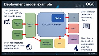
The OGC API family of standards are being developed to make it easy for anyone to provide geospatial data to the web. These standards build upon the legacy of the OGC Web Service standards (WMS, WFS, WCS, WPS, etc.), but define resource-centric APIs that take advantage of modern web development practices. This web page provides information on these standards in a consolidated location.

These standards are being constructed as "building blocks" that can be used to assemble novel APIs for web access to geospatial content. The building blocks are defined not only by the requirements of the specific standards, but also through interoperability prototyping and testing in OGC's Innovation Program.
To learn more about using the OGC APIs please view our guidelines here.

The OGC API Roadmap highlights the current and planned standards efforts as well as related extensions to those standards and Innovation Program and other projects influencing and refining the process of standardization.

For more information on the OGC API standards, please contact us using the form below.

To find out more about the OGC please visit our public site. OGC Logo

What's New

OGC API standards in the news

Card image cap
OGC Member Meeting Developer Track

Developers are invited to the Developer Track of the 119th OGC Member Meeting

The Open Geospatial Consortium (OGC) invites software developers to the Developer Track at the 119th OGC Member Meeting, on Wednesday 16 June 2021 from 10:00 EDT to 18:00 EDT.

Registration at ogcmeet.org.

API Prospectus
OGC APIs prospectus available

Are you interested in supporting OGC APIs, or would like to learn more about them? Be a part of OGC's evolution of standards. Download our prospectus now.

Executable Test Suite Available

The executable test suite for the OGC API - Features - Part 1: Core (OGC 17-069r3) is now available in the OGC Validation beta environment.

If you would like to register your product implementation:
  1. Register your implementation in the OGC database: Register
  2. Then link your implementation to the test results in the beta website.

Your implementation will then appear in the OGC database as an official implementation.


If you have any issues, please report them directly to the GitHub project page: https://github.com/opengeospatial/ets-ogcapi-features10/issues

Thank you and happy testing!

APIs

Features

Approved Standard

OGC API - Features - Part 1: Core and Part 2: Coordinate Reference Systems by Reference are both publicly available.

Common

OGC API - Common provides those elements shared by most or all of the OGC API standards to ensure consistency across the family. The candidate standard will soon be released for public review.

Maps

OGC API - Maps offers a modern approach to the OGC Web Map Service (WMS) standard for provision map and raster content.

Records

OGC API - Records updates OGC’s Catalog Services for the Web by building on the simple access to content in OGC API - Features.

Processes

OGC API - Processes allows for processing tools to be called and combined from many sources and applied to data in other OGC API resources though a simple API.

Coverages

OGC API - Coverages allows discovery, visualization and query of complex raster stacks and data cubes.

Tiles

OGC API - Tiles provides extended functionality to other OGC API standards to deliver tiled data, such as Map Tiles.

Styles

The OGC API - Styles defines a Web API that enables map servers, clients as well as visual style editors, to manage and fetch styles...

EDR

Environmental Data Retrieval (EDR) API provides a family of lightweight interfaces to access Environmental Data resources. Each resource addressed by an EDR API maps to a defined query pattern.

DGGS

Enables applications to organise and access data arranged according to a Discrete Global Grid System (DGGS).

Routes

Enables applications to request routes in a manner independent of the underlying routing data set, routing engine or algorithm.

Sprints

OGC continues to use special events, hackathons, and sprints to validate the OGC API draft candidate standards as those standards evolve. By including the broadest possible selection of stakeholders, OGC can be confident that when the standards are published, those standards have already withstood testing and suitability evaluation.

  • May 2021

    May 2021 OGC API Virtual Code Sprint

    Find out more about this event taking place on May 26-28.
    The code sprint will run from 07:00am EDT until 05:30pm EDT each day.

OGC Web API guidelines

The OGC Architecture Board (OAB) considers architecture consistency and life cycle management of the OGC standards baseline. The OAB has developed OGC Web API Guidelines to be followed when building Web API standards. These guidelines are not mandatory or policy, rather their purpose is to assist standards developers to use common patterns and better align their efforts.

OGC API Videos

Click on a video below to begin viewing it.

video
OGC APIs: The Building Blocks for Location
video
OGC API Overview and Implementation
video
OGC API update - presented to the ESIP - November 2020
OGC’s WaterML 2.0 Quenches New Zealand’s Thirst for Information Integration
Bringing STAC into OGC

Since their beginning, the SpatioTemporal Asset Catalog (STAC) specification and OGC API - Features have been evolving together and continually aligning. This post explains the relationship between STAC, OGC API - Features, and OGC itself.

Read blog
OGC’s WaterML 2.0 Quenches New Zealand’s Thirst for Information Integration
A New Look for the Portrayal of Geospatial Information

Together, the Open Portrayal Framework and the SymCore standard define a modern and modular approach to portrayal based on the intent to have many extensions from a common conceptual model and many encodings of those extensions.

Read blog
OGC’s WaterML 2.0 Quenches New Zealand’s Thirst for Information Integration
Swimming in Data: OGC’s WaterML 2.0 Quenches New Zealand’s Thirst for Information Integration

By exploiting one of their most precious resources — water — OGC standards helped Kiwis conquer one of their most vexing challenges: disparate data sources. Like so many nations, New Zealand is engaged in a contentious game of environmental tug-of-war.

Read blog
OGC API - Maps Virtual Code Sprint
Revolutionizing Location data through accessibility: The OGC APIs Maps Virtual Code Sprint

On July 28 and 29, 2020, OGC hosted a virtual sprint to advance the OGC API - Maps candidate standard, one of many APIs being rolled out by the organization to revolutionize how location information is accessed and shared across the industry.

Read blog
Building an Interoperable Routing Engine (Part 1)
Building an Interoperable Routing Engine (Parts 1 & 2)

The goal of the Open Routing API Pilot was to develop an API that allowed requests for routes from different users in an interoperable and standardized way via Web protocols.

Read blog
OGC API - Tiles and its refinement at the 2020 Sprint

Further testing and refinement to the OGC API - Tiles candidate standard - the spiritual successor to one of OGC’s most popular standards, the Web Map Tile Service (WMTS) - has occurred during another successful OGC Sprint. The candidate standard is just one of several efforts forming OGC’s move towards modular, resource-oriented, OpenAPI-based standards.

Read blog
The OGC Environmental Data Retrieval API: simple access to big data

Another step towards the creation of the OGC Environmental Data Retrieval (EDR) API Standard has been completed: the successful testing of some of the API’s capabilities during the OGC Environmental Data Retrieval API Sprint.

Read blog
OPF Hands
Open Portrayal Framework

Sharing Styles and Updating Tiles for a New Generation of Maps

Read blog
OGC APIs blog
OGC APIs and the evolution of OGC standards
Read blog

Supporting Documents

OGC and other documents supporting OGC API efforts.

The OGC API standards rely heavily upon fundamental concepts expressed in OGC White Papers and research and testing performed in Innovation Program activities and documented in Engineering Reports. OGC members are also specifying best practices for the use of web APIs and often share that guidance. The documents below provide some background to OGC API efforts.

OGC API – Common and OGC API – Features Sprint 2020: Summary Engineering Report OGC API – Maps Sprint 2020: Summary Engineering Report OGC Testbed-16: OpenAPI Engineering Report OGC Testbed-16: Data Centric Security Engineering Report OGC Testbed-16: OpenAPI Engineering Report OGC Testbed-16: DGGS and DGGS API Engineering Report OGC Testbed-16: Data Access and Processing Engineering Report OGC Testbed-16: Data Access and Processing API Engineering Report OGC Testbed-16: Machine Learning Training Data ER OGC Testbed-16: Aviation Engineering Report OGC Testbed-16: Earth Observation Application Packages with Jupyter Notebooks OGC Vector Tiles Pilot 2: Summary Engineering Report OGC Vector Tiles Pilot 2: Tile Set Metadata Engineering Report OGC Vector Tiles Pilot 2: Vector Tiles Filtering Language Engineering Report FGDC OGC Application Programming Interface Interoperability Assessment OGC API Prospectus Testbed-15 Styles API Engineering Report Testbed-15 Maps and Tiles API Engineering Report Testbed-15 Images and Changes Set API Engineering Report OGC Open Geospatial APIs - White Paper Joint OGC-W3C Spatial Data on the Web Best Practices OGC Testbed-14: Next Generation Web APIs - WFS 3.0 Engineering Report OGC Testbed-14 Next Generation APIs: Complex Feature Handling Engineering Report OGC Testbed-14: Application Package Engineering Report OGC Testbed-14: ADES & EMS Results and Best Practices Engineering Report OGC Testbed-14: Swath Coverage Engineering Report OGC Vector Tiles Pilot: WFS 3.0 Vector Tiles Extension Engineering Report Vector Tiles Pilot Extension Engineering Report API strategie voor de Nederlandse overheid (section in English)
Show more +

Innovation Program activities

The OGC Innovation Program provides a world-recognized process for users of geospatial technology to collaborate and share the advancement of technologies for future enterprise architectures.

If you have an idea for an initiative or simply have a question or comment, contact Ingo Simonis, Head of the OGC Innovation Program.


Use of OpenAPI in legacy OGC standards

While the OGC API standards are being developed in concert around common core elements, some older OGC web service standards have been described using OpenAPI. Examples of these legacy enhancements are found below.

Get In Touch