Skip Navigation Linkweather.gov 
NOAA logo-Select to go to the NOAA homepage National Weather Service   NWS logo-Select to go to the NWS homepage
Central Pacific Hurricane Center

Local forecast by
"City, St" or Zip Code
  
   RSS FeedsRSS Feeds
Get Storm Info
   Products
   Satellite
   Radar
   Analyses/Forecasts
   Hydrology
   E-mail Updates
   Help with Advisories
Awareness
   Hurricane Safety
       Info

   Tropical Cyclone
      Names

   Saffir-Simpson
      Scale

   Glossary
   Acronyms
   FAQ
   Breakpoints
Hurricane History
   Annual Summaries
   Product Archive
   Climatology
About the CPHC
   Our Mission
   Our Office
   News Items
   Hawaii RSS FeedsHI RSS Feeds
Contact Us

Pacific Region Links
   Regional HQ
   WFO Honolulu
   WFO Guam
   WSO Pago Pago
   Pacific Tsunami
      Warning Center

   International
      Tsunami
      Information
      Center

   Pacific ENSO
      Application
      Center


USA.gov is the U.S. government's official web portal to all federal, state and local government web resources and services
Follow the National Weather Service on Facebook
NWS on Facebook
Follow the National Weather Service on Twitter
NWS on Twitter
Weath
er-Ready Nation
Weather-Ready Nation

NOAA > NWS > CPHC

This page was last loaded at 7:44 pm HST Sep 4, 2015 (544 GMT Sep 05, 2015)

Central Pacific (140W to 180) xml button

Active Systems
xml button  Post-Tropical Cyclone Ignacio Advisory Number 045
Issued at 500 PM HST FRI SEP 04 2015
SUMMARY OF 500 PM HST...0300 UTC...INFORMATION
----------------------------------------------
Location: 35.5N 164.5W
ABOUT 1060 MI...1705 KM NNW OF HONOLULU HAWAII
ABOUT 810 MI...1300 KM N OF FRENCH FRIGATE SHOALS
Maximum sustained winds: 65 MPH...100 KM/H
Present movement: N or 355 degrees AT 16 MPH...26 KM/H
Minimum central pressure: 985 MB...29.09 INCHES


xml button  Hurricane Jimena Advisory Number 038
Issued at 500 PM HST FRI SEP 04 2015
SUMMARY OF 500 PM HST...0300 UTC...INFORMATION
----------------------------------------------
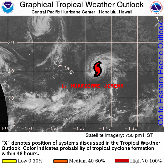
Location: 20.3N 145.6W
ABOUT 620 MI...995 KM E OF HILO HAWAII
ABOUT 795 MI...1280 KM E OF HONOLULU HAWAII
Maximum sustained winds: 75 MPH...120 KM/H
Present movement: NNW or 330 degrees AT 3 MPH...6 KM/H
Minimum central pressure: 981 MB...28.97 INCHES


Tropical Outlook Sea Surface Temperatures CPAC Satellite EPAC Satellite Widgets Satellite Message Forecast Discussion
Tropical Weather Outlook RSS Feed

Issued: Sep 04, 2015 2:00 pm HST

TROPICAL WEATHER OUTLOOK
NWS CENTRAL PACIFIC HURRICANE CENTER HONOLULU HI
200 PM HST FRI SEP 4 2015

For the central north Pacific, between 140°W and 180.

1. The Central Pacific Hurricane Center in Honolulu, Hawaii is issuing advisories on tropical storm Ignacio, located 965 miles north-northwest of Honolulu Hawaii, under AWIPS header TCPCP3 and WMO header WTPA33 PHFO.

2. The Central Pacific Hurricane Center in Honolulu, Hawaii is issuing advisories on hurricane Jimena, located 635 miles east of Hilo, Hawaii, under AWIPS header TCPCP4 and WMO header WTPA34 PHFO.

Elsewhere, no tropical cyclones are expected through Sunday afternoon.


GIBBS


Greyscale Satellite GRB Scale Satellite No Satellite

Comments about this graphic/product? Please send us an email.

Western Pacific (West of 180)

Monitored by the:
Joint Typhoon Warning Center
Japan Meteorological Agency

Eastern Pacific (East of 140W) xml button

Eastern Pacific Graphical Tropical Weather Outlook


TROPICAL WEATHER OUTLOOK
NWS NATIONAL HURRICANE CENTER MIAMI FL
1100 PM PDT FRI SEP 4 2015

For the eastern North Pacific...east of 140 degrees west longitude:

The National Hurricane Center is issuing advisories on Tropical
Storm Kevin, located a few hundred miles west of the southern tip of
the Baja California peninsula.

Showers and thunderstorms have changed little in organization since
earlier today near a low pressure area located about 550 miles
south of Manzanillo, Mexico. However, environmental conditions are
conducive for development, and a tropical depression is likely to
form over the weekend while the low moves northwestward at 5 to 10
mph well offshore of the coast of Mexico.
* Formation chance through 48 hours...high...70 percent
* Formation chance through 5 days...high...90 percent


Eastern Pacific Graphical Tropical Weather Outlook

Monitored by the National Hurricane Center (NHC)

divider

Hurricane Preparedness

State of Hawaii Civil Defense
Oahu Civil Defense
Kauai Civil Defense
Maui Civil Defense
Hawaii (Big Island) Civil Defense

Lat/Lon Distance Calculator
Calculate the distance between lat/lon points
Tropical Cyclones Centers Worldwide
Saffir-Simpson Scale
  • Tropical Storm - winds 39-73 mph (34-63 kt)
  • Category 1 - winds 74-95 mph (64-82 kt)
  • Category 2 - winds 96-110 mph (83-95 kt)
  • Category 3 - winds 111-130 mph (96-113 kt)
  • Category 4 - winds 131-155 mph (114-135 kt)
  • Category 5 - winds 156 mph and up (135+ kt)
Click for AtlanticClick for Central Pacific