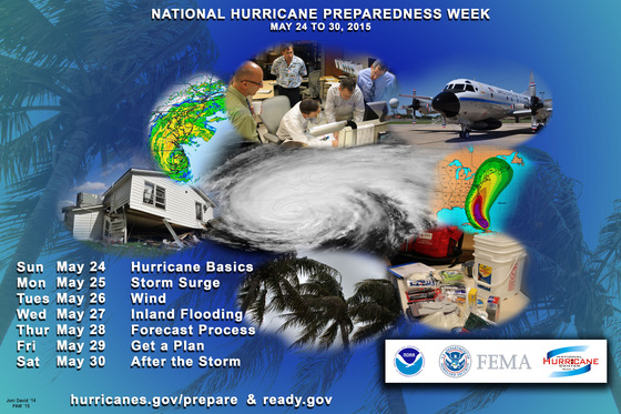
Hurricane Preparedness Week
The National Weather Service and its National Hurricane Center are working to improve
the content available on the NHC website.
Click on this link to see the new Hurricane Preparedness Week Webpage!

Help spread the word! Check out the
Hurricane Preparedness Social Media Plan (PDF)
for more information.
Download the Tropical Cyclone Preparedness Guide (PDF)
or keep reading below for more information. But remember, this is only a guide. The first and most
important thing anyone should do when facing a hurricane threat is to use common sense.
| OVERVIEW |
HURRICANE HAZARDS |
FORECAST |
PREPARE |
ACT |
|
Basics
|
Storm Surge
|
Winds
|
Inland Flooding
|
Forecast Process
|
Get A Plan!
|
Take Action
|
 |
 |
 |
 |
 |
 |
 |
Sunday
24 May '15
YouTube
EN
ES
Audio
EN
ES
|
Monday
25 May '15
YouTube
EN
ES
Audio
EN
ES
|
Tuesday
26 May '15
YouTube
EN
ES
Audio
EN
ES
|
Wednesday
27 May '15
YouTube
EN
ES
Audio
EN
ES
|
Thursday
28 May '15
YouTube
EN
ES
Audio
EN
ES
|
Friday
29 May '15
YouTube
EN
ES
Audio
EN
ES
|
Saturday
30 May '15
YouTube
EN
ES
Audio
EN
ES
|
|
|
It only takes one storm to change your life and community.
Tropical cyclones are among nature's most powerful and destructive phenomena.
If you live in an area prone to tropical cyclones, you need to be prepared.
Even areas well away from the coastline can be threatened by dangerous flooding,
destructive winds and tornadoes from these storms. The National Hurricane Center
issues watches, warnings, forecasts, and analyses of hazardous tropical weather.
The primary hazards from hurricanes are storm surge flooding, inland flooding
from heavy rains, destructive winds, tornadoes, and high surf and rip currents.
While hurricanes pose the greatest threat to life and property, tropical storms
and depressions can also be devastating. Flooding from heavy rains can cause
extensive damage and loss of life. For example, Tropical Storm Allison produced
more than 40 inches of rain in the Houston area in 2001, causing about $5 billion
in damage and taking the lives of 41 people.
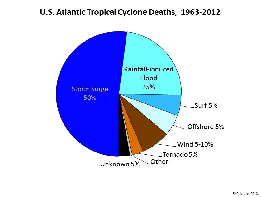
Storm surge has the potential to cause the largest loss of life in hurricanes.
Since 1963, storm surge has caused nearly half of the deaths in the United States in
tropical cyclones. Water, not wind, has accounted for nearly 90 percent of all
tropical cyclone deaths in the U.S. during that time.
Storm surge is dangerous because a mere six inches of fast-moving flood water can
knock over an adult. It takes only two feet of rushing water to carry away most
vehicles–including large pickup trucks and SUVs.
The strong winds of a hurricane can cause widespread destruction. Hurricane Hugo was
a fast-moving, category 4 storm that made landfall near Charleston, South Carolina.
Hugo brought destructive hurricane-force winds hundreds of miles inland, downing numerous
trees and power lines over a swath from the Atlantic coast to the southern Appalachians.
Millions were left without power and the resulting damage totaled in the billions of dollars.
Tornadoes are also common with landfalling tropical systems. In recorded history, almost every
tropical storm and hurricane that has come onshore in the U.S. has produced a tornado. These
tornadoes most often occur in thunderstorms embedded in the storm’s rainbands, well away
from the center of the hurricane.
Strong winds of a tropical cyclone can also cause dangerous waves that pose a significant hazard
to mariners and coastal residents and visitors. When the waves break along the coast, they can
produce deadly rip currents, even at large distances from the storm. In 2008, despite
the fact that Hurricane Bertha was more than a 1,000 miles offshore, the storm resulted in rip
currents that killed three people along the New Jersey coast and required 1,500 lifeguard
rescues in Ocean City, Maryland, over a 1 week period.
The Time to Prepare is NOW!
What should you do to prepare for a hurricane?
Get a plan.
The most important step is to identify your hurricane risk. Do you live in an evacuation zone?
If so, you need to plan on where you and your family would ride out the storm if you are told to
evacuate. Most people only need to evacuate a few miles from the coast to avoid the dangers of storm
surge. Find a friend or relative that lives outside the storm surge evacuation zone and have a plan
to ride out the storm with them. You should also establish a family communications plan in case you
are not together when you need to evacuate.
Once a person understands their risk for hurricane impacts, an appropriate disaster safety plan
should be developed to help ensure an individual’s and a family’s safety. A disaster safety
plan is a comprehensive plan that identifies all of the steps a family needs to take before, during,
and after a disaster to ensure maximum personal safety and property protection. For a step-by-step guide
on creating a family disaster plan please see
Florida’s “Get a Plan” guide.
Citizens should also visit their State Emergency Management Agency websites
for family disaster plan templates that may be more suited to a local area.
Coastal residents should go to their local emergency managers for evacuation zone information. This
information is typically available on-line. A county-by-county list of evacuation zone resources is
available at:
http://flash.org/hurricane-season/evacuation-zones/Evacuation_Zone_Identification_Survey.pdf
Resources
Vital resources to help you prepare include:
What We're Doing
The mission of the National Weather Service (NWS)
is to provide weather, water, and climate data, forecasts and warnings for the protection
of life and property and enhancement of the national economy. Its vision is of a
Weather-Ready Nation, one that is prepared for and responds
to weather-dependent events.
The mission of the National Hurricane Center (NHC)
is to save lives, mitigate property loss, and improve economic efficiency by issuing watches,
warnings, forecasts, and analyses of hazardous tropical weather and by increasing understanding
of these hazards. The NHC vision is to be America's calm, clear, and trusted voice in the eye of the
storm and, with its partners, enable communities to be safe from tropical weather threats.
The NWS and NHC are issuing several new storm surge products that will highlight areas most at
risk from storm surge flooding from a threatening hurricane. The NHC now issues a Potential Storm
Surge Flooding Map, which shows the geographical areas where inundation from storm surge could occur and
how high above ground the water could potentially reach in those areas, based on the latest official
NHC forecast and its likely errors. The NWS will begin issuing a prototype Storm Surge Watch/Warning
Graphic in 2015 to highlight those areas along the Gulf and Atlantic coasts of the United States that
have a significant risk of life-threatening inundation by storm surge from a tropical cyclone. This map
introduces the public to the concept of an NWS storm surge watch and warning, which is expected to become
operational in 2017.
Click to Download Poster
(also available in Spanish)
|


