Using Technology and Innovation to Reengineer Our Surveys and Data

Bookmark and Share

Written by: John H. Thompson

At the U.S. Census Bureau, we’re researching ways to use technology to transform the way we do business. Not only will this transformation keep our censuses and surveys quick, easy, and secure, it will reverse the decades-long trend of increasingly more expensive operations.

Over the past four years, we’ve researched cost-saving innovations. We’ve come up with an exciting blueprint of what is possible in a census when we entirely rethink our operations and leverage technology. The President’s FY 2016 budget, released yesterday, funds the design of these systems and the testing of those together with new operations.

While 2020 might seem like a long way off, it is coming quickly: we must design operations, test systems and bring them together to “lock down” the final plan by 2018 to be ready by 2020. Our proposals for transforming the census through technological innovation include:

• Reengineering address canvassing: Prior to every Census, we compile a list of every housing unit in America. Developing a high-quality address list is crucial to the success of the census. By using address updates from the U.S. Postal Service and local governments – combined with imagery and private sector sources – we can drastically cut the cost of editing this list.

• Maximizing self-response: Our experience with the American Community Survey and the 2012 Economic Census demonstrate the promise of the Internet for maximizing self-responses to surveys. By allowing respondents to easily answer the questionnaire online, we can save millions on the costs of mailing out, getting back, scanning and hand-keying the information from paper forms into our system. At the same time, we need to authenticate online responses to ensure that they are genuine and not duplicative.

• Using administrative records: Another way that we can make our operations more efficient is by using records from other federal agencies to improve our counts of people and places.

• Reengineering field operations: In 2010, much of the on-the-ground work by Census Bureau field representatives was done on paper. By adopting technology to automate work, we can make field operations more efficient and reduce our paperwork burden.

As you can imagine, designing systems of this scale takes time, and we only have one chance to “get it right.” That’s why we began planning for 2020 even before the 2010 Census, and why these next few years of testing, development and implementation are so important. We need to design, develop, and build our data collection and processing systems; test them individually for function; and then test them together to ensure that they function in a real-world setting.

Of course, the Census Bureau’s work includes much more than the decennial census, and our proposals for innovation reflect that. In other areas of our agency, we’re focusing on:

• Census Enterprise Data Collection and Processing: With millions of people responding to our many surveys and censuses each year, the Census Bureau does an enormous amount of data collection and processing. In the past, we created unique data collection and processing systems for every survey. Now, we’ll integrate and standardize those systems across the organization. This will save money and time, and help us to manage our operations in the most efficient way possible.

• Administrative records clearinghouse: Part of the mission of the federal statistical system (which includes the Census Bureau) is to “provide quality, unbiased data to support reasoned, disciplined decisions.” This clearinghouse will include administrative data from federal and federally-sponsored programs, making them easier to use. Researchers, program administrators and policy makers can access and evaluate the program records easily and use them to provide new insights and evidence for sound decision-making.

• Geographic support: The Geographic Support Systems Initiative enable us to make ongoing updates to our address lists and maps, and supports our efforts to reengineer the address canvassing operation for the 2020 Census by continually updating the Census Bureau’s address list throughout the decade. It increases the amount of addresses provided by state and local partners that we can add to our address list, and prepares us to use updates from commercial data and other sources. Crucially, the initiative provides updates for rural addresses, addresses in Puerto Rico, and group quarters.

• American Community Survey: The American Community Survey releases over 11 billion estimates each year, and is used to distribute more than $400 billion of federal dollars each year. We will research how we can reduce respondents’ burden, while keeping data quality high.

• Economic Census and Census of Governments: We need to streamline our processes in order to support 100% electronic responses to these censuses to increase their cost-effectiveness. We will also introduce new data products for maximum data quality and usefulness.

The 2020 Census will be unlike any other in census history. The next few years are critical to this effort. I encourage anyone who is interested in this process to follow along as we research, test and plan. You can watch our meetings online and participate through a civic dialogue. The census – which is an enumeration of the entire nation – will only succeed with the participation of the nation.

For an overview of the Census Bureau’s FY 2016 budget, you can view this infographic.

Posted in About the Agency, Uncategorized | Tagged , , | Leave a comment

Improving Your Access to U.S. Census Bureau Data: Two New Features on Census.gov

Bookmark and Share

Written by: John H. Thompson

Recently, we rolled out two exciting new features on Census.gov — a better search engine and a new version of QuickFacts. Since the launch of Census.gov in 1994, the Internet has changed a lot. In an age of instant communication and 24/7 information sharing, our users want anytime, anywhere access to timely and relevant statistics. The Census Bureau is committed to making the statistics that define our growing, changing nation more accessible than ever before. Through these features, the Census Bureau is increasing the availability and usefulness of the statistics we collect from the American public.

searchOur new “smart search” not only provides the statistics you are looking for directly on the search page, but also shows visualizations of popular search topics and links to related information. You can now get statistics from multiple Census Bureau data sources on popular topics such as income, poverty and population.

For example, if you search for “California population,” the latest state population statistics, tables and visualizations will appear.  You’ll also see other statistics about California that you might be interested in, such as median household income or total housing units. You can filter search results by images and videos as well.

Our search function now also includes NAICS (North American Industry Classification System) codes, making business information easier to access. Business leaders will instantly find information essential to their industries.

Based on customer feedback, we’ve also released a completely reimagined QuickFacts site, available in beta at www.census.gov/quickfacts. Prior to this revamp, the QuickFacts application had been virtually unchanged since its launch in 2000. This new version maintains the original ease of use but also includes many improvements, like fully interactive, customized tables that let you view statistics for up to six locations side by side. Want to view data on a map instead of a table? Now you can.

We’ve also added charting, social media sharing, and type-ahead search. Now you can just enter your desired location and QuickFacts does the rest. And it’s not just functionality that’s new — for the first time, QuickFacts includes profiles for townships, as well as locations in Puerto Rico.

These features are just the latest in the Census Bureau’s digital transformation effort, developing new tools using the latest technologies. We’ve made major upgrades to Census.gov so that our almost 50 million annual visitors can more easily find the information they want. We also created an application programming interface (API), three mobile apps and several interactive data tools.

We hope you’ll try out our new smart search and QuickFacts beta. Tell us what you think online or via email at cnmp.web.comments@census.gov. We think you’ll really like what you see.quickfacts

Posted in About the Agency, Digital Transformation | Tagged , | Leave a comment

Everything You Want to Know About the Census Bureau Is Just a Phone Call Away

Bookmark and Share

Written by: John H. Thompson

As you might have seen on Twitter, on Tuesday I took a tour of the call center at U.S. Census Bureau headquarters — and even answered a few calls myself. The call center — in addition to our facilities in Jeffersonville, Ind.; Tucson, Ariz.; and Hagerstown, Md. — is one of our agency’s major hubs for answering and tracking questions and concerns from the American public. In a world of instant communication, our customers expect an immediate response to their questions. Our call center staff is here to give real-time answers over the phone, online chat and email.

During my “shift,” I took a call from a college freshman, who asked me what students should know about the Census Bureau. I told him that the data we collect are extremely important to our nation and is used for creating legislative districts, congressional apportionments and funding allocations – and also that the Census Bureau is always hiring in lots of disciplines!

During my “shift,” I took a call from a college freshman, who asked me what students should know about the Census Bureau. I told him that the data we collect are extremely important to our nation and is used for creating legislative districts, congressional apportionments and funding allocations – and also that the Census Bureau is always hiring in lots of disciplines!

So, what kind of questions does the call center get? Many questions are about our censuses or surveys — in fact, our centers in Jeffersonville, Tucson and Hagerstown are dedicated to communicating with survey respondents. Often, people have never heard of the census or survey that has just arrived at their home or business. I talked to one respondent to the American Community Survey, who wanted to make sure the survey wasn’t a scam. I was happy to reassure her that it was legitimate and important — her responses will provide data that federal, state and local leaders use to plan for things like roads, schools and hospitals.

The call center here in Suitland, Md., also answers all kinds of data questions. County and local officials call to ask about their municipality’s official population count. Researchers ask for information on a wide range of topics, from income to housing to international trade. During my visit, I saw one call center employee answer a chat question about how to appropriately cite information from Census.gov.

In addition to helping callers, the call center also helps the Census Bureau by reporting on the questions and data requests they receive. By listening to callers’ feedback, we can make improvements to our mailed materials and website to help the public find the information they need quickly and easily.

The Census Bureau spends a lot of time reaching out to the public to encourage them to fill out our censuses and surveys, and to ensure they trust that we will protect the information that they provide. When someone contacts us, a call center employee is often the first and only Census Bureau employee they interact with— and I’m proud of the good impression that our employees make. No matter what your question for the Census Bureau is, our call center staff are standing by and ready to answer it.

———————–

Census Bureau Headquarters in Suitland, Md. 1-800-923-8282 Monday – Friday: 8 a.m. to 5 p.m. ET Email and chat at https://ask.census.gov Monday – Friday: 8:30 a.m. to 5 p.m. ET

If you have been contacted about a survey or census and want to verify that the person who called you is a Census Bureau employee, have a question about a survey form you received, or need to return a call about one of our surveys, please call one of the centers listed below.

Hagerstown, Md. Telephone Center 1-800-392-6975 Monday – Friday: 9 a.m. to 9 p.m. ET Saturday: 9 a.m. to 7 p.m. ET Sunday: 11 a.m. to 9 p.m. ET

Jeffersonville, Ind. Telephone Center 1-800-523-3205 Monday – Saturday: 7 a.m. to 9 p.m. ET Sunday: 11 a.m. to 9 p.m. ET

Tucson, Ariz. Telephone Center 1-800-642-0469 Monday – Friday: 6 a.m. to 10 p.m. MT Saturday: 7 a.m. to 7:30 p.m. MT Sunday: 9 a.m. to 10 p.m. MT

TDD/TTY 1-800-877-8339


Posted in About the Agency | Tagged | 2 Comments

Using Data to Understand and Combat the Spread of HIV/AIDS

Bookmark and Share

Written by: John H. Thompson

Today is World AIDS Day, an annual opportunity for people around the world to unite against HIV/AIDS, to support those who are living with HIV and to commemorate those who have died. The Joint United Nations Programme on HIV/AIDS (UNAIDS) estimates that in 2013, 35 million people worldwide lived with HIV, and there were about 1.5 million AIDS-related deaths.

Map showing Total Population and Population Missing Due to HIV/AIDS Epidemics: 2012 (For Africa)

The HIV/AIDS pandemic has affected the populations of many countries. The 10 countries selected in the above image have suffered the combined loss of more than 14.5 million people.

Tracking and compiling data are important elements in understanding and combatting the spread of HIV and AIDS. The Census Bureau has tracked key data relating to HIV and AIDS for many years. In 1987, we created the HIV/AIDS Surveillance Data Base in collaboration with the U.S. Agency for International Development, and it continues to be supported with funding from the President’s Emergency Plan for AIDS Relief.

Today, the Data Base contains over 164,000 records from more than 14,900 sources, with more added every year. It is a major compilation of HIV prevalence and incidence data. In fact, the Data Base is the most comprehensive resource of its kind in the world, and includes records for all countries and areas with a population of at least 5,000, with the exception of North America (including the United States) and U.S. territories. These records help identify patterns in the spread of infection, which can assist decision-makers, academics and healthcare professionals who conduct research to help end the HIV/AIDS pandemic.

Researchers at the Census Bureau also use data to assess the impact of increased mortality due to HIV. Using pregnant women’s HIV infection rates, they can estimate and project the prevalence of HIV infection and mortality rates at a national level. Census Bureau population estimates and projections that incorporate the effect of HIV/AIDS are now available for more than 50 countries.

Information about the HIV/AIDS epidemic and impacts on population is critical for decision-makers in developing countries, program planners and the international development community. I am proud of the Census Bureau’s history of collecting, analyzing and publishing data that can help in efforts to diminish the spread of this disease.

Posted in Measuring America | Tagged | Leave a comment

Happy 25th Anniversary, TIGER

Bookmark and Share

By John H. Thompson

When you think of the U.S. Census Bureau, you probably think of surveys and statistics. But did you know that geography is also a big part of our work? Geography plays an important role in creating surveys and collecting data, and it provides meaning and context for our statistics. The Census Bureau conducts research on geographic and address topics, makes reference maps to support censuses and surveys, and creates tools to visualize geographic and statistical data.

The Census Bureau’s history of mapping population data dates back to the 1860s. Under the direction of Census Superintendent Francis Amasa Walker and Chief Geographer Henry Gannett, the Bureau produced the Statistical Atlas of the United States, a landmark publication that contained innovative data visualization and mapping techniques.

Blog_IMG1A century later, the Census Bureau was a leader in the early development of computer mapping. In the 1970s, James Corbett of the Statistical Research Division devised a system of map topology that assured correct geographic relationships. His system provided a mathematical base for most future Geographic Information Systems (GIS) work and helped spark the development of computer cartography.

However, at that time, the Census Bureau still relied heavily on paper maps. Census Bureau geographers and cartographers used some computer-scanned mapping files, covering about 280 metropolitan areas, to create paper maps for enumerators to use. For the rest of the nation, paper maps came from a variety of sources, varied in quality and scale, and were quickly outdated.

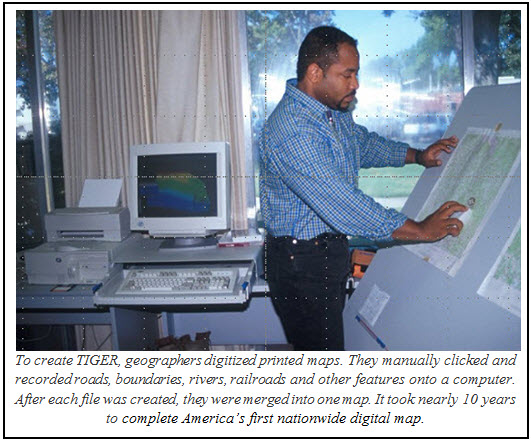
Finally, in preparation for the 1990 Census, the Census Bureau, in collaboration with the U.S. Geological Survey, developed the first nationwide digital map of the U.S., Puerto Rico and other territories called the Topologically Integrated Geographic Encoding and Referencing (TIGER) database. As a national digital map, TIGER contains all of the geographic features — such as roads, railroads, rivers, and legal and statistical geographic boundaries — that are necessary to support the Census Bureau’s data collection and dissemination programs. I was a Census Bureau employee when TIGER debuted, and I still remember the excitement surrounding it. It was hugely innovative and represented an exciting step forward in the way we collect data.Blog_IMG2

Over the past 25 years, TIGER has evolved into a dynamic mapping system that helped catapult the growth of the GIS industry and improve Census Bureau data products. Today, TIGER is updated annually and available for free download. It provides the nation with a valuable set of geographic information that anyone can use — including businesses, government, nongovernmental organizations and the public. Every state and local government has the capability to create its own GIS with our small-area census data.Blog_IMG3

The Census Bureau’s history is one of innovation. From the Hollerith tabulating machine to the use of UNIVAC I and the development of TIGER, we have made significant technological advancements — and we will keep on doing so. As the 2020 Census approaches, we are continuing to improve TIGER each year in order to deliver the most timely and reliable statistics.

Happy anniversary, TIGER!

Posted in About the Agency, Geography, Measuring America | Tagged , , | 3 Comments