Marine planning is a relatively new approach to managing our seas. The aim is to ensure a sustainable future for our coastal and offshore waters through managing and balancing the many activities, resources and assets in our marine environment.
Marine planning will contribute to the effective management of marine activities and more sustainable use of our marine resources. The objective is to make the most of our marine space; maximising the potential of some activities and at the same time safeguarding the future of others.
It follows a similar approach to terrestrial planning setting the direction for decision making at a local level to lead to efficient and sustainable use of marine resources.
Marine planning will:
- guide marine users to the most suitable locations for different activities
- manage the use of marine resources to ensure sustainable levels
- work with all marine users to ensure everyone has an opportunity to contribute to marine plans
- take a holistic approach to decision making and consider all the benefits and impacts of all the current and future activities that occur in our marine environment
Why is marine planning relevant for recreational boating?
Although recreational boating developments are likely to be relatively small scale, all operators and regulators in a marine area will be expected to work to the same plan, providing transparency and consistency in decision-making. It is therefore important that recreational boaters are aware of and understand the implications of new marine plans as they are developed around the UK.
Boaters should engage with the marine planning process in their area to ensure the importance and value of recreational boating is recognised. The RYA is working to ensure that no marine plan policies restrict boating or discourage the development of improved facilities and access.
How will marine planning be done?
The Marine and Coastal Access Act 2009 divides the UK marine areas into marine planning regions with an associated plan authority who prepares a marine plan for the area. In Scotland, Wales and Northern Ireland, the devolved administrations are the planning authorities and in England, the Marine Management Organisation (MMO) are the planning authority.
To find out more about how each country is planning their marine environment and to learn about how the RYA is working to represent the interests of recreational boaters, click on the relevant country tab above.
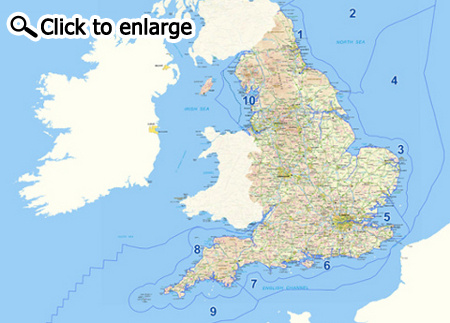
In England, the inshore and offshore waters have been split into 11 marine plan areas illustrated in the map below. (Please note that on the map there are 10 plan areas, with the North West area shown as a single area, divided by a dashed line to reflect the recommendation by stakeholders that the inshore and offshore areas are prepared under a single process and one plan is produced representing both areas.)
The MMO are aiming to work with stakeholders to produce a marine plan for two areas every two years. Unless significantly different, both the inshore and offshore areas in a particular region will be planned for at the same time. The MMO have have produced an explanatory marine planning animation.
The development of each marine plan goes through a number of stages before reaching completion and stakeholder involvement is key. From establishing the baseline to developing the draft planning policies, stakeholder input is essential to ensuring the finished plans are realistic, workable and adoptable.

Where have they got to with marine planning in England?
England's first marine plans - the East marine plans - were published on 02 April 2014 and cover the area Flamborough Head to Felixstowe.
In January 2012 work started on the South Inshore and Offshore Marine Plan Areas with public workshops being held in Exeter, Brighton and Southampton. Following the workshops the MMO published their Statement of Public Participation (SPP) which identifies how and when they plan to engage the public throughout the development of the South Marine Plans. The SPP also contains a draft timeline for the plan making process in the South which suggests completion of the Plans by the end of 2014.
How is marine planning relevant to boaters?
It is vital that boaters engage with the planning process to ensure the importance of recreational boating is recognised by the MMO as they draft marine plans around England. The RYA worked hard through the development of the East Inshore and Offshore Marine Plans together with local boaters to make sure the value of our activity along the east coast was recognised. We also worked to ensure that no policies were included that restricted boating or discouraged development of improved facilities and access.
Stretching between Folkestone in Kent and the River Dart in Devon, the South Marine Plans will cover some of the most important areas for recreational boating in England. As well as the significant economic contribution from recreational boating along the south coast, it forms a key part of the cultural character of the area which is steeped in maritime history. Once again the RYA will be working closely with the MMO to ensure impacts on boating are seriously considered as the draft policies are drawn up.
How can you get involved in marine planning?
Anybody who lives or is in any way involved in a marine plan area can participate in the planning process. Further stakeholder workshops are planned for the South Marine Plans in the autumn of 2013 and the SPP describes how you can be involved in those.
Opportunities for public participation in marine planning elsewhere around England will be publicised as and when plan development starts.
The RYA will continue to engage directly with the MMO on a national as well as a local basis in a coordinated manner to ensure recreational boating remains a key consideration. We will endeavour to keep members informed about how they can get involved making good use of our Regional Committees as well as our e-newsletters.
Further information is available from the MMO's website and you can also sign up to receive regular updates by email.
The Northern Ireland Marine Bill, which was introduced into the Northern Ireland Assembly in February 2012, complements the Marine and Coastal Access Act 2009. When enacted, the NI Marine Bill will establish the Department of the Environment (DOE) as the Marine Plan Authority for Northern Ireland's inshore (0-12 nautical miles) and offshore (beyond 12 nautical miles) regions respectively.
The DOE plan to prepare marine plans for the inshore and offshore regions simultaneously under one plan making process and publish them as one composite document which will be referred to as the Northern Ireland Marine Plan.
In June 2012 the DOE published a Statement of Public Participation (SPP) which identifies how and when they plan to engage the public throughout the development of the Marine Plan. The RYA together with RYA Northern Ireland is engaging closely with the DOE to ensure that recreational boating is given due consideration.
Further information can be found on the DOE Planning Portal where you can sign up for e-mail alerts.
The introduction of the Marine (Scotland) Act 2010 means the Scottish Government now has the authority to introduce statutory marine planning for Scotland's seas. Unlike England, Scotland will have a National Marine Plan which will apply across the country and Regional Marine Plans to deliver local detail.
The Scottish National Marine Plan
The Scottish National Marine Plan will manage increasing demands for the use of the marine environment, encourage economic development of marine industries and incorporate environmental protection into marine decision making. It will also have a role to play in managing adaptation to climate change.
The National Marine Plan - pre-consultation Draft was launched in 2011. The pre-consultation Draft is being revised in response to comments made during the pre-consultation. Consultation on the Draft National Marine Plan and Sustainability Appraisal is anticipated in summer 2013.
Scottish Marine Regions
Where national marine planning sets the wider context for planning within Scotland, regional marine planning will allow more local ownership and decision making about the specific issues within a smaller area. Following consultation a system of 11 regional marine plans for Scottish waters will be drawn up around 11 Scottish Marine Regions (SMRs), the boundaries of which are illustrated in the map below.

How has the RYA been involved in marine planning in Scotland?
Together with RYA Scotland (RYAS), the RYA has been working closely with Marine Scotland to influence to marine planning process in Scotland.
Much of the evidence which has been used to draw up the National Marine Plan is illustrated in Scotland's Marine Atlas which is available to view online. The RYA contributed to the data contained within this Atlas in order to ensure that recreational cruising routes were built into the evidence base.
RYAS were also involved in the consultation process on the boundaries of the SMRs and is continuing to engage on this issue as it progresses.
How can you get involved in marine planning?
The Scottish Government has published a Statement of Public Participation SPP) which identifies how and when they plan to engage the public throughout the development of the National Marine Plan. As well as including a timetable for creating the plan the SPP provides detail on workshops and written consultation exercises in which members of the public can engage.
The RYA together with RYAS will be responding to the draft National Marine Plan when it is published to ensure recreational boating remains a key consideration. We will endeavour to keep members informed about how they can get involved making good use of RYAS Coastwatchers, the RYA and RYAS websites and through our e-newsletters.
The Welsh Government has responsibility for marine planning in the Welsh marine area. Due to resourcing issues, progress on marine planning has been slower than anticipated in Wales. In 2011 the Welsh Government consulted on their proposed approach to marine planning in Wales. This put forward an approach that is similar to Scotland with a National Marine Plan supported by Regional Marine Plans where necessary to deliver local detail.
The RYA together with the Welsh Yachting Association (WYA) has been engaging closely with the Welsh Government on the issue of marine planning to ensure that recreational boating is given due consideration.
Further information can be found on the Welsh Government website (in English and Cymraeg).