River Colne - Up river guide
The RYA guide to the River Colne
The Colne has carried the history of Britain up to the oldest recorded Roman Town of Colchester. The town was the provincial capital of Britain until it was razed to the ground by Boudica in AD61. The town was built again and suffered further battles throughout the ages from Vikings to being bombed by zeppelin airships.
It was an important trade route until the closure of Colchester Port in 2000. Now commercial traffic has all but disappeared leaving a net full of fishing boats and the rest to leisure boats and liveaboards. The river is an East Coast classic and the towns and villages along its course document the Colne’s varied history throughout the ages.
Brightlingsea approach
Brightlingsea Spit South Cardinal marks the branch off the Colne to Brightlingsea Creek. A starboard beacon opposite the cardinal features a tide gauge giving the minimum depth over the bar when following the leading marks into the Creek. The distinctive Bateman’s Tower is a useful reference point on the shore and is surrounded by colourful beach huts. Leave the cardinal to port, head north east towards the green buoy or keep the two white and red leading marks on the shore in transit. A North cardinal marks the start of the moorings.


Brightlingsea
Contact the Brightlingsea Harbourmaster for berthing (VHF Ch 68). There are visitors berths on mid river pontoons or it may be possible to get a berth in the Waterside Marina. Brightlingsea has a public hard, a couple of sailing clubs, shops, pubs and a boatyard offering all the normal facilities.
Fingringhoe and Alresford creek
Back on the Colne and passing Brightlingsea Creek, Pyfleet creek lies to the West and offers a popular anchorage. As you pass the ruined pier at Fingringhoe on the Western bank, the Colne channel bends to the north. Alresford creek branches to the East as you pass starboard (21) buoy. The sand quarry is visible in the distance.


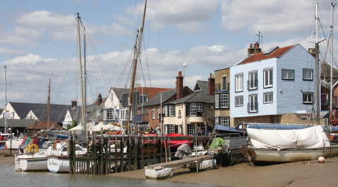
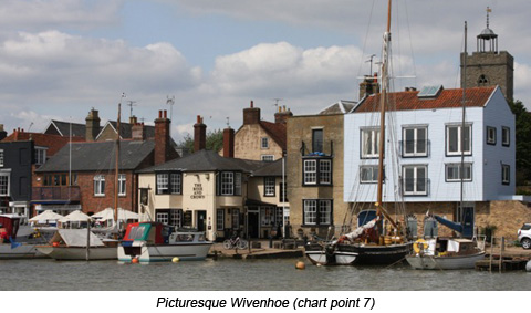
Wivenhoe
Continuing North, follow buoyage until reaching the port hand mark (30) where the river ventures North West once more. The commercial wharf at Ballast Quay signal the approach of the Wivenhow tidal barrier. The tidal barrier is open most of the time, however it shuts on the highest tides to prevent flooding further upstream. On the Northern bank, Wivenhoe Sailing Club offers visitor moorings on the club’s drying pontoon.

The earliest record of boatbuilding at Wivenhoe is 1575 and since then it has seen shipyards building fishing smacks, cargo vessels, minesweepeepers and MTBs. One of the last vessels built was the sail training ship, The Lord Nelson. Wivenhoe is a picture postcard East Coast town with riverside pubs alongside the mud berths and moorings.
Rowhedge
Further upstream and on the western bank Rowhedge, with it’s riverside green and houses set further back, offers plenty of mooring. Rowhedge had it’s own brewery and with its strong maritime connections supplied crew for the gentries racing yachts. The quay wall can be used by visiting boats for a short stay or capable of taking the mud. There are a couple of pubs on the waterfront; The Anchor pub has a ladder on the sea wall allowing access from the river.

Approach to Colchester
Heading North from Rowhedge and passing numerous mud berths, the once bustling river slowly narrows and meanders through the local wildlife site of Hythe Marsh on the western side. This leads upto the aptly named and now disused Haven quay just past the sewage works.

Colchester
 Ships transporting goods to Colchester were a frequent sight until 2000 when the port closed. The lack of dredging and large boats transiting the river has allowed silting, but there is still enough water for the adventourous. In recent years investment in the area has seen improvements to King Edward Quay, now home to many liveaboards and the Sea Cadets, with plans for further redevelopment. The starbard bank hosts a retail park, hotel and student accommodation.
Fact file
VHF
|
| Brightlingsea Harbour |
Ch.68 |
Brightlingsea Water Taxi
|
Ch. 37 or phone 07535 508537 |
Tides
| Walton on the Naze |
Range |
Heights |
| Spring |
3.8m
|
MHWS 4.2
|
MLWS 0.4
|
| Neap |
2.3m
|
MHWN 3.4
|
MLWN 1.1
|
| Brightlingsea |
Range |
Heights |
| Spring |
4.6m
|
MHWS 5.0
|
MLWS 0.4
|
| Neap |
2.6m
|
MHWN 3.8
|
MLWN 1.1
|
| Colchester |
Heights |
| Spring |
MHWS 50
|
MLWS dries
|
| Neap |
MHWN 3.5
|
MLWN dries
|
Public slipway
- Brightlingsea
- Rowhedge (contact the Brightlingsea Harbour Master for details of its use)
Charts
Imray C1
Imray Y17
BA 5607
BA 1183
BA 1975
BA 3741


© Crown Copyright and/or database rights. Reproduced by permission of the Controller of Her Majesty’s Stationery Office and the UK Hydrographic Office (www.ukho.gov.uk).
This material is not for resale, redistribution or copying.
Not to be used for navigation.
Thanks
Chart Y17 is reproduced with the kind permission of Imray. www.imray.com
Chart copyright UKHO. www.ukho.gov.uk
Written by Simon Jinks, RYA Yachtmaster™ Examiner and marine journalist on behalf of the RYA
Contact UsArticle Published: September 14, 2011 13:49
Article Updated: August 19, 2013 16:20