- Home
- Affordability Projects
Affordability Projects
Catastrophes have damaged or destroyed property worth tens of billions of dollars in recent years. These disasters have highlighted the importance of protecting communities that regularly face risks as well as the need to provide access to affordable insurance. They have also demonstrated the need for Australia’s built environment to be less brittle in the face of natural disasters such as storms, cyclones, bushfires and floods.
The Insurance Council of Australia (ICA) is working closely with all levels of government and consumers to help communities understand risks and work towards practical solutions. Close collaboration between industry and government is critical to identifying appropriate disaster solutions, and the community needs clear signposts about steps they can take to manage their own exposure to risk from natural disasters.
The ICA has initiated several programs to tackle the impacts of extreme weather and the availability of hazard data to help understand risk and develop a more sustainable response to managing catastrophes.
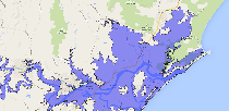
National Flood Information Database (NFID)
ICA Data Globe

JCU Engineering Inspections: North QLD strata-title properties