
Chart plotter - friend or foe?
It was once said that, ‘the art of navigation is knowing where you are not’.
Thanks to GPS we can now be a bit more accurate. But like any aid or technique, GPS cannot do all the work for us especially as its positions can be more accurate than charts themselves.
Chart plotters superbly portray the vessels position for general navigation but when entering harbours they may be giving a false sense of security.
GPS
GPS can be accurate to about 3-15 metres depending on the receiver type and the conditions. Signal and accuracy can be affected by the antennae not seeing enough satellites or not receiving reliable information.
A handheld GPS used inside the cabin may get shielded from many satellites and give a spurious or inaccurate fix. Small patch antennae on deck or on the aft rail, if shielded, will throw the position.
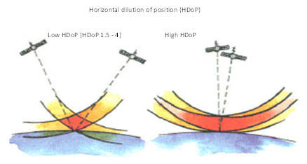
If you need to check GPS accuracy, for example if you are using the unit in pilotage situations, look at the value of Horizontal Dilution of Precision (HDoP) on your GPS/chart plotter. Low values indicate a more accurate fix than high ones. Check your manual as some systems portray signal information differently.
Charts
 Whilst GPS can pinpoint our position to just a few metres, it is doing so on a chart that may have last been surveyed by someone with a lead line in a sailing boat.
Check the ‘source data’ box on the chart and see when it was last surveyed; you may be surprised. Most busy harbours are continually dredged and surveyed using GPS, but smaller harbours, rocky outcrops and coastlines even in the UK may not have been looked at for a very long time.
Up until 1935 surveying was carried out randomly using a lead line and positions referenced to landmarks. Echo sounders were used from 1935 but they were not referenced to electronic fixing until 1950 and only gave the information directly beneath them.
Even for detailed harbour charts the survey was conducted at approximately 62.5m intervals allowing dangers inside the lines. Only in the mid-seventies did side scan sonar come in and give a truer picture of the seabed. This was not referenced to satellite navigation until the mid-eighties.
This means it is possible for a sunken tanker to be hidden in between the survey lines and on occasion, this has been found to be the case. The pinpoint accuracy of GPS has to be measured against the charted inaccuracies on the seabed which the UKHO state could be over 200m in places.
Datums
 Most charts are referenced to a particular horizontal datum to which the chart was constructed. A horizontal datum is a reference system for specifying positions on the Earth’s surface. GPS usually outputs its position in a datum called WGS 84.
If the chart and the GPS datum match, the positions can be plotted straight on the chart with confidence. Many up to date UKHO paper charts now work to a WGS 84 compatible datum so that both chart and GPS positions match.
If they do not match, positional errors occur. In the UK, the previous common datum was OSGB 36 or ED50, and differences between the GPS reading out in WGS 84 gave around 130m positional errors.
There are well over 60 different chart datum around the world and when the Admiralty chart of St Lucia was recently transferred from a local datum to WGS 84, the coast ‘moved’ by 1000m.
 Notes on the chart, (Positions – Satellite Derived Positions) indicates to which datum the chart is constructed and if it is not WGS84 states the positional adjustments in minutes. The datum shift around a country is not constant. (see illustration).
It is possible to set the GPS to output its position in a different datum, but the GPS is usually given an average value to offset by and so still may not give the exact position, more of a ‘best-educated guess’ say to within 20-30m.
Whilst the most accurate way to plot GPS positions on non-WGS84 charts is to calculate the difference manually, often the best a small vessel can achieve is to set the GPS to output in the same datum as the chart.
 Many overseas charts still work to a different datum and some even suggest you should not use GPS to fix your position on those charts, so beware. The largest datum discrepancy presently found is in New Zealand where there is a seven mile error.
Electronic leisure charts
Marine leisure plotters, in the main, use unofficial charts many of which offer useful extra features, such as pictures, but the charts may not tell the whole navigational story.
When a plotter is switched on, it states that; ‘the plotter should not be used as the primary navigational source and should be used in conjunction with official and up to date charts of the country’.
Occasionally, important data is missed or not shown at a particular level of zoom and some shallow patches or charted items are not where you expect them, although they will be on an official paper chart.
This year whilst cruising through a known shortcut, a 0.6 depth was omitted from the chart in an area of 2m depths. As I only had 1m clearance in the 2m depths, it would have been problematic had I not consulted the paper chart and steered around it.
Sometimes when a datum shift is applied to the electronic leisure chart the same shift is applied for the whole sea area whereas, in reality, the shift changes subtly around the coast, once again increasing the total error.
As you zoom into an electronic chart on your chart plotter, the information you see can never be greater than the scale that it was surveyed at many years before which could have been with a lead line in a lumpy sea. As the vessel is portrayed in the centre of the screen, it can lead to a false sense of security.
Conclusion
Give any navigational information a sanity check. When using a plotter, a quick glance out of the window at a passing buoy or mark is often all that is required to double check the plotter knows where you are. A double check with an up to date paper chart confirms that paper and electronic chart match.
Check the datum of the chart so you can assess its accuracy especially if the charts are old or you are overseas .
The plotter is a great bit of kit and tremendously useful. But that exact position to 3m is often a lot more exact than the chart it is displayed on, especially in pilotage situations using electronic charts.
Simon Jinks, RYA Yachtmaster™ Instructor/Examiner.
Contact UsArticle Published: August 01, 2012 11:25