No Fix? Easily fixed
Simon Jinks shows us how radar can be used for pilotage.
While heading towards Plymouth Sound recently the GPS would not pick up a signal and give us a fix. The plotter still displayed Plymouth Sound in all of its glory. The cursor happily displayed its latitude and longitude, but the top corner of the screen stated, ‘NO FIX’.
We guessed it was an electrical fault giving power to the active antennae but we were unable to trace it. However, it certainly wasn’t going to cause us a problem - I was running a RYA Yachtmaster™ Instructor Course and nearly everyone on board had a handheld GPS or smart phone to display position. We also had radar.
Using radar for pilotage
Some of the candidates had a good knowledge of radar. Those that had radar on their boats often used it for collision avoidance, but not so much for pilotage.
The RYA Yachtmaster™ Instructor course has a large emphasis on pilotage as this is where many skippers come unstuck. Radar has a huge advantage over a chartplotter because it gives a true picture of where the land and hard objects actually are, compared to where a software programmer constructing a leisure electronic chart thinks they are. So, we decided to use the radar, combined with other tools, as a pilotage aid.
Night entry into Newton Ferrers
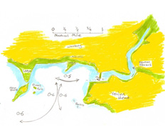
The culmination of the various pilotage exercises undertaken during the course was a night entry into Newton Ferrers, a small West Country harbour just to the East of Plymouth.
The harbour is unlit until you are within the channel, where there is one small lit buoy to greet you.
The entrance has many challenges, such as the unlit Mewstone and its off lying rock patches, Church Ledge which extends 0.4nm out to sea and a narrow entrance into the harbour with a sand bar.
The surrounding land was mostly steep-to so gave a good echo which showed up well on the radar.
To keep the pilotage simple we used one radar technique for the whole entry and that was distance-off the coast.
Safe distances were worked out to clear the obstructions and the radar range rings were switched on and adjusted so that the range rings mostly corresponded to the range that we required to clear the obstructions.
 To clear the Mewstone and its off-lying rocks we gave it a 0.6 mile clearance.
As we started to track north we stayed central between the Mewstone and Yealm Head to safely enter Wembury Bay.
The rambling rocks of Church Ledge were just underwater but we gave them a safe distance by staying half a mile from shore. This half mile point is also where the only lit mark comes into view.
When the light was directly to the East we started to head towards it. The range was reduced on the radar to monitor our progress as we entered the channel and the Yealm River.
Radar, combined with the vigilant use of an echo sounder and a few bearings gave us the tools for a pretty solid plan into the Yealm. The radar gave us confirmation of how far off the land we were at all times and by preplanning what our safe distances were, we kept in safe water.
Inside the Yealm

Words, photos and illustrations by Simon Jinks RYA Yachtmaster™ Instructor and Examiner
©Searegs 2012 www.searegs.co.uk
Contact UsArticle Published: August 01, 2012 11:28