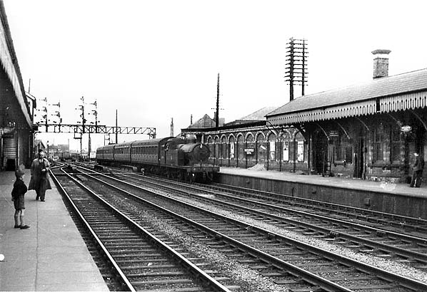
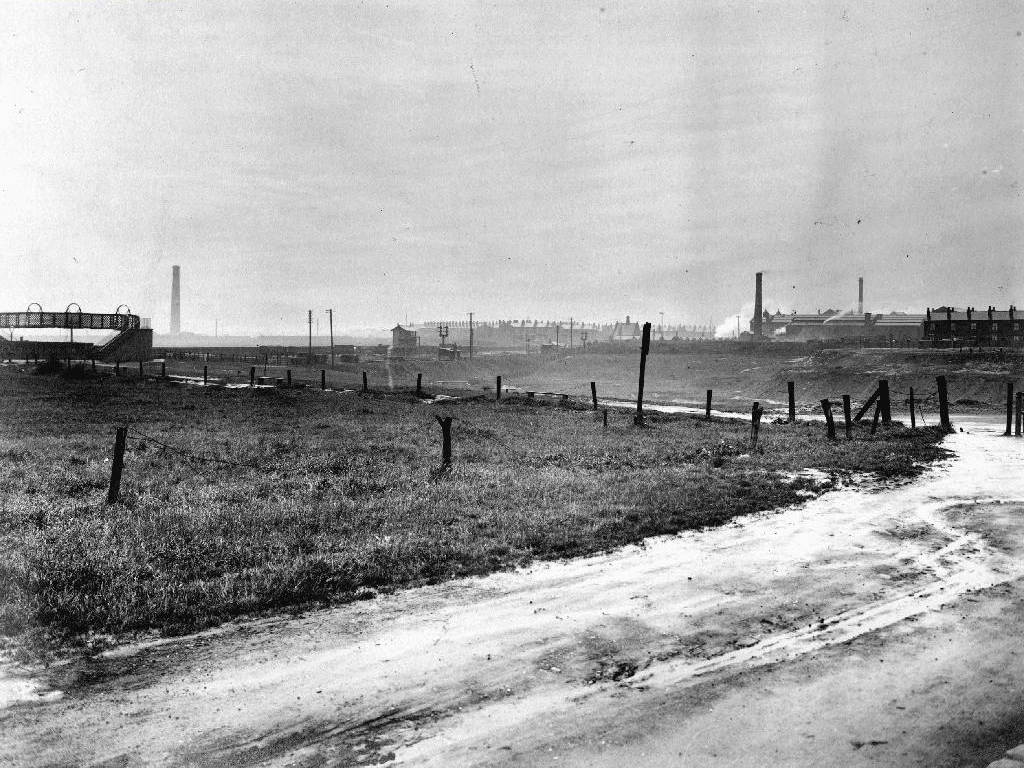
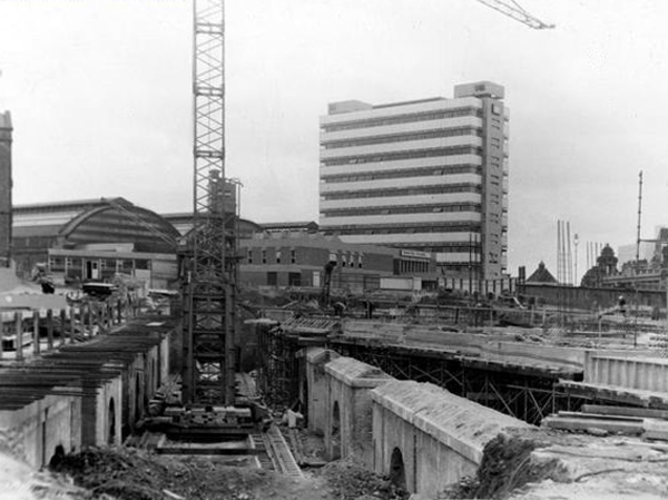
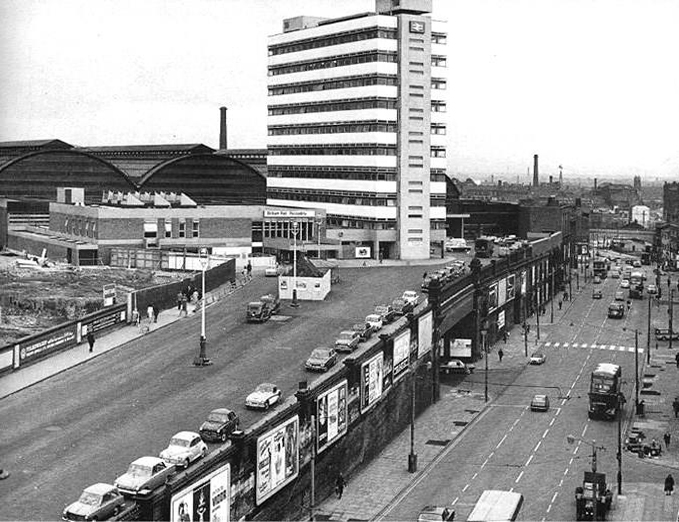
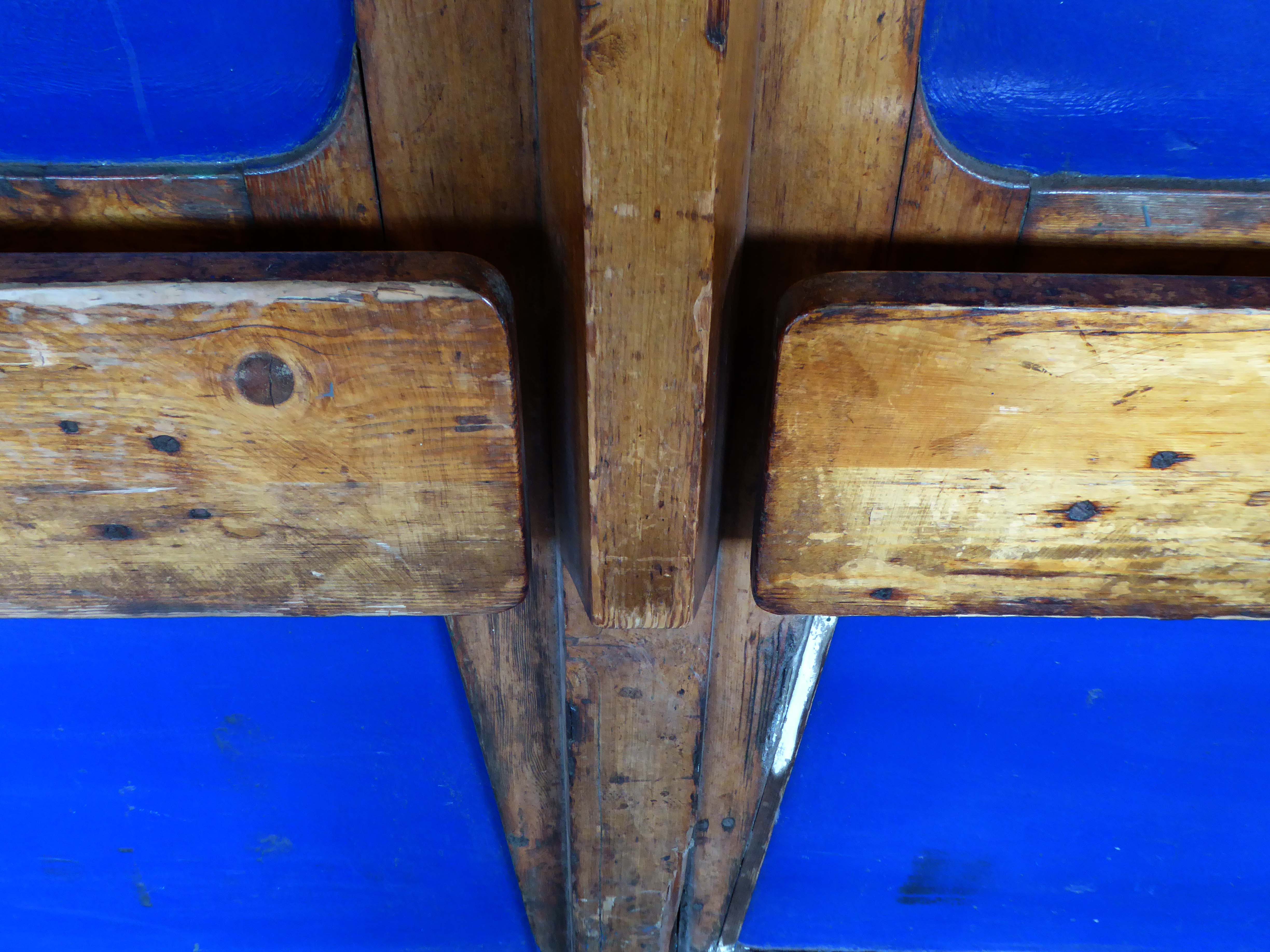
Wolverhampton High Level Station was built in 1852 and lay on what used to be known as the Stour Valley Line. The modern day Wolverhampton Station now occupies the site and there is little left of what my father photographed as the station suffered a major phase of modernisation in the mid 1960’s.
The present Wolverhampton station dates from 1964 to 1967 when the High Level station was completely rebuilt by the architect Ray Moorcroft as part of the modernisation programme which saw the West Coast Main Line electrified.
More recently in 2004, a new through platform – platform 4, was constructed on the site of infrequently-used sidings. This has greatly enhanced the capacity of the station. A new footbridge was also constructed, to allow access to the new platform but also to improve access to the existing ones.
Members of the public are now able to access the second half of the new Wolverhampton railway station, following the completion of main construction on Phase 2 in March 2021.
The new station forms part of a significant local transformation being carried out, as part of the city’s £150m Interchange scheme. Within the city scheme, there are improvements planned for bus, Metro, cycle and train connectivity.
This was my first visit to Wolverhampton, arriving at 8.42 on a crowded Bournemouth bound Cross Country train, which was destined to terminate at Reading.
By wandering aimlessly, all places became equal, and it no longer mattered where he was.
Paul Auster City of Glass.
The station as built in 1961 to a design by the architect William Robert Headle, which included and advertised a significant amount of the local Pilkington Vitrolite Glass. The fully glazed ticket hall was illuminated by a tower with a valley roof on two Y-shaped supports. The platform canopies were free standing folded plate roofs on tubular columns.
The new station building and facilities were assembled just a few yards from the 1960s station building and is the third build on the same site. The project came in at a total estimated cost of £6 million, with the European Union contributing £1.7 million towards the total funding. The new footbridge was lifted into place in the early hours of 22 January 2007.
The striking Pilkington’s glass-fronted building was designed by architect SBS of Manchester. Construction work was completed in the summer, with the new waiting rooms and footbridge opened to passengers on 19 September. The new station building was officially opened on 3 December 2007.
In the early Edwardian era a fine theatre was opened on 1st June 1903. It had been designed by local architect J A Baron and was on the site of an earlier theatre known as the Peoples Palace. It was operated as the New Hippodrome Cinema from 8th August 1938 when it reopened with Anna Neagle in Victoria the Great. On 1st September 1963 it was converted to a Surewin Bingo Club by Hutchinson Cinemas which continued to operate in 2008. By May 2019 it was independently operated as the Hippodrome Bingo Club.
Onwards down Corporation Street to Century House, currently awaiting some care and attention and tenants.
Century House is a prominent landmark in St Helens town centre, being the tallest office building in place. The accommodation ranges over 9 floors, providing offices from a single person, to whole floors. In addition, all tenants benefit from the use of a modern break out space and meeting rooms, in addition to manned reception desk.
The Capitol Cinema opened on 3rd October 1929 by an independent operator. It stood on a prominent corner site at North Road and Duke Street – known as Capitol Corner.
The Capitol Cinema was taken over by Liverpool-based Regent Enterprises Ltd. in 1929, and by the Associated British Cinemas – ABC chain in 1935. It underwent a renovation in the 1960’s, and was closed by ABC on 9th December 1978.
The building was converted into a sports centre, by 2009 it was a Central Fitness gymnasium.
Along the way to St Mary Lowe House RC – the style is a combination of Gothic and Byzantine elements. One of the most unusual fittings is the carillon, one of the largest in the British Isles with 47 bells, which was installed in 1930 and is still played regularly.
The main approach is identified by a beak-like porch which projects from the main cladding. In this space hangs a recast eighteenth century bell, from the original chapel.
Let’s take it to the Midland, Nat West and Barclays Banks.
With an intermediate former Gas Showroom.
Next to the Church of St Helen.
Architect: WD Caroe 1920-26 Grade II Listed
A chapel has been on the site since at least the 16th century. The chapel was doubled in size in 1816, but burnt down in 1916. It is the parish church of the town, and stands in a prominent position.
St Mary’s Car Park a multi-storey masterpiece straight outa Dessau.
Next crossing a complex web of inner ring roads designed with the beleaguered pedestrian at the forefront of the planners’ minds.
To the inter-war Pilkington’s Offices – Reflection Court
Architects: Herbert J Rowse and Kenneth Cheeseman 1937-41 Grade II Listed.
Since 1867 Reynolds has grown from a small shop to the largest furniture store in Sussex, with over 30,000 sq ft on four floors.
The Funeral Service now has three offices in Bognor Regis, Chichester and Littlehampton and the purpose built storage facility in Canada Grove continues to thrive.
We soon found ourselves in Felpham, amongst yet more interesting housing.
We traversed the River Arun at Littlehampton.
Then meshed with the milieu on the prom.
The day grew much hotter and we grew ever so slightly loster.
Finding our way back to the coast through the Kingston Gorse Estate – where almost everything is comprehensively prohibited.
Kingston Gorse is a beautiful seaside location close to Goring-by-Sea in West Sussex. In Kingston Gorse, there is a gorgeous housing development with a number of three, four and five bedroom homes.
In 1918 JA Candy, who owned East Kingston Farm, sold the land on which Kingston Gorse now stands to the local builder G Pesket.
In the 1920s he constructed the infrastructure and developed approx. 30 plots including Imray, which he occupied.
East Didsbury Station was opened in 1909 by the London and North Western Railway and, until 6 May 1974, was called East Didsbury and Parrs Wood.
From 1923, the line was operated by the London Midland and Scottish Railway. Following the formation in 1948 of British Rail, rail services were operated by the London Midland Region of British Railways, then North-Western Regional Railways.
I often walk around here, the space enclosed by the River Tame and the M60, it was a maze of busy streets, home to peoples’ homes, industry, pubs, clubs and railways.
Much of that is now gone, either left to its own devices, untended rough empty ground, or overwritten by the newly built Tesco Extra and Porsche dealership.
Water Street, Portwood looking north, taken from Avenue Street. Looking underneath the railway bridge, on the left hand side, the first building used to be a public house called ‘The Beehive’, further along was Kent & Swarbrick’s Tripeworks, now a precision engineers, then North West Concrete Works – Easymix. On the right is Coxson’s Brushworks, then the Portwood Mill, Kershaw’s Tannery and the Meadow Mill at the bottom of the street.
The area was also home to the Blood Tub boxing ring.
Outside the Blood Tub Back Water Street Portwood.
Centre row left to right Billy PittTaylor Micky PelhamJack HulmeJo Moran owner John MorryBobby RileyLaurie Glen a jockey
2nd row from the back – James Jimmy Rose.
Back row left to right – Charlie Dean An ambulance man Ike Irelands horse dealer – Team from Macclesfield.
Extreme right – Jo Mulrooney.
Front row left to right extreme left – Sidney Smith soft Sidney – a simpleton Jo Hulme.
Copied from a photograph lent by Eddie Pitt
Alligator Rainwear – a British company, whose main factory was based in Beehive Mill. It was best known for its 1960s collaborations with Mary Quant in the design and production of her Wet Look collection of PVC raincoats.
The firm was started after the First World War by Reuben Satinoff, who had previously founded the London Waterproof Company – Silkimac. It was taken over by his sons after the Second World War. For decades, it manufactured traditional weatherproof raincoats in black, brown and beige, but the collaboration with Quant led to new fabrics including PVC and nylon, and a range of bright and vibrant colours.
At its peak in the 1960s and 1970s, Alligator had a turnover of £5 million per year and was exporting its products to Europe and North America. It was later owned by Baker Street Brands who describe it as one of their heritage brands.
Viewed from Tiviot Dale Viaduct
Tiviot Dale station was located on the Cheshire Lines Committee (CLC) operated Stockport, Timperley and Altrincham Junction Railway line from Portwood to Skelton Junction, a section of what became the Woodley to Glazebrook line. It was situated at the bottom of Lancashire Hill, next to the present motorway bridge. It was opened on 1 December 1865 and was originally known as Stockport Teviot Dale. From 1880, Tiviot Dale was also served by long-distance trains running on the Manchester South District Railway to London St Pancras.
Tiviot Dale remained a part of the CLC, which was jointly owned from 1923 by the London and North Eastern Railway and the London Midland and Scottish Railway, until 1948 when it became part of the British Railways London Midland Region.
The lines through the station remained in heavy use by coal trains heading for Fiddlers Ferry power station near Warrington from the Woodhead Line. These, however, ceased in 1980 when damage was caused to the nearby Tiviot Dale tunnel during construction work on the M63 motorway – now M60 motorway and the line temporarily closed for safety reasons. The closure was made permanent west of Bredbury’s stone terminal in 1982, following the demise of the Woodhead route; the track was subsequently lifted in 1986 and the tunnel partially filled in. The area surrounding the station was further altered at the beginning of the 21st century to allow the construction of a supermarket and office buildings, which now block the old trackbed.
Portwood Railway Station was on the Stockport and Woodley Junction Railway – later becoming part of Cheshire Lines Committee – Glazebrook to Woodley line. According to Bolger it opened to passengers on 12 January 1863, along with the rest of the Stockport and Woodley Junction Railway, although Butt suggests it opened on 1 December 1865 when the Stockport, Timperley and Altrincham Junction Railway opened.
The station opened for goods traffic in 1865, closing to passengers on 1 September 1875, when it became a goods station. It remained in use until 25 April 1966 when it closed except for coal traffic which continued until 27 March 1972 when it closed entirely except for a private siding.
Today no trace of the station remains, the site being buried under a slip road of the M60 motorway.
Monica Clarke on her tricycle in Marsland Street, behind her across the cobbled street is the Sheba Works – 1951.
Marsland Street east, showing the Haymarket Chambers – 1967
The front of Haymarket Chambers Marsland Street.
Boarded up dwellings on Compstall Court, off Marsland Street.
Portwood Cut 1968
James Harrison bought the manor of Brinnington in the early 1780’s – by 1790 Harrison had three factories in Portwood and others were to follow. In 1796, to provide sufficient water-power to this industrial zone he constructed a substancial millrace. Known as the Portwood Cut, it carried water across the Tame, between his Reddish and Brinnington estates. Harrison also planned the construction of factories at Wood Hall but that particular scheme was abandoned after his death in 1806.
Harrison’s Weir still survives on the river. To the south sections of the Portwood Cut also survive within Reddish Vale Country Park, both as a shallow depression and as water-filled, if somewhat silted and overgrown channel.
Kershaws is one of the only original businesses which still trades in the area.
Established back in 1855 by Joshua Kershaw, the company has gone from strength to strength.
Way back then, it was just a tannery. Today, seven generations on, Edward Kershaw heads a company that is known and respected for it’s quality leather in Europe, America and the Far East.
Kershaws also provide white leather for masonics and bagpipes.
Brewery Street – a view of the steps leading to the railway footpath to Tame Street – 1967.
The mill in the foreground is the Portwood Spinning Mill now called Portwood Mill – on the front of the mill it states Sir Richard Arkwright Portwood Mill.
Employees – Portwood Spinning Company
Coal drops and yard at the rear of the Beehive Spinning Mill
Tame Street gave motorized access to the Cut and here the caravans of travelling folk were parked several times a year, usually until the police ‘moved them on’. The men collected and sold scrap metal, the women sold clothes pegs and told fortunes from door to door. Many of the local people treated them with suspicion and some local pubs would not admit them.
Building work on Lancashire Hill can be seen in the background – 1968
Abbey Stadium Goredale Avenue Gorton Manchester M18 7HD.
Abbey Hey FC was formed in 1902 in the Abbey Hey district of Gorton, some three miles away from the centre of Manchester. During their formative years and through the two World Wars, the club was disbanded and reformed on a number of occasions. Starting in the Church Sunday Leagues, they progressed through the Manchester Amateur Leagues during the intervening years but the club really came into it’s own in the 1960s after it took in the players of the Admiralty Gunning Engineering Department following it’s closure.
In 1978 with the club decided to apply for a position in the Manchester League, this meant that the club had to find an enclosed ground suitable for playing their home games. The nearest ground available at the time was in Chorlton at Werburghs Road.
In 1984 the club at last had their own home,improvements to the ground could only have been achieved by the hard work and dedication of the committee, who not only raised the money to carry out the improvements but also carried out 90% of the work themselves.
Promotion to the 1st Division meant that the club had to install floodlights. True to form, they designed, ordered, erected and wired them within a couple of months. The biggest job during the ground improvements was the building of the new clubhouse and dressing rooms. Planning permission was given with the majority of work once again being carried out by the club’s own members.
This is a story of persistence and commitment from members, managers and players – keeping a viable non-league football team alive at the centre of a Community.
I have cycled by here for years, along the Fallowfield Loop – and worked down here in the Seventies when the rail link was still extant.
Photo – Neil Ferguson-Lee via Robert Todd and Levy Boy.
So today seeing the gates open, I decided to take a look around the ground – many thanks to groundsman Simon for taking the time to stop and chat.
Everything is spick and span, the playing surface in excellent nick, and all the stands seat and fences standing smartly to attention, having had a fresh coat of paint.
So let’s take a look around:
I’ll be back to watch a match, just as soon as the rules and regulations allow!
Tuesday 28th July 2015 waking up early on the outskirts of Okehampton – I went next door to explore – the Wash and Go.
I went back to Okehampton.
Headed out of town along the old railway line to Plymouth – where rests the solemn remains of previous railway activity and Meldon Quarry.
It’s believed that the first quarrying began around the late 1700s when the local limestone was extracted. Over the years this gradually gave over to aggregate quarrying and apelite quarrying until it final closure. The original owners of the quarry were the London and South Western Railway and then came Britsh Rail and finally EEC Aggregates.
Crossing Meldon Viaduct.
Meldon Viaduct carried the London and South Western Railway across the West Okement River at Meldon on Dartmoor. The truss bridge, which was constructed from wrought iron and cast iron not stone or brick arches, was built under the direction of the LSWR’s chief engineer, WR Galbraith. After taking three years to build, the dual-tracked bridge opened to rail traffic in 1874. Usage was limited to certain classes of locomotive because the viaduct had an axle load limit. Although regular services were withdrawn in 1968, the bridge was used for shunting by a local quarry. In the 1990s the remaining single line was removed after the viaduct was deemed to be too weak to carry rail traffic.
The crossing is now used by The Granite Way, a long-distance cycle track across Dartmoor. The viaduct, which is a Scheduled Monument, is now one of only two such surviving railway bridges in the United Kingdom that uses wrought iron lattice piers to support the cast iron trusses – the other is Bennerley Viaduct between Nottinghamshire and Derbyshire.
On an old railway line with prefabricated concrete railway huts.
And a bus stop at Mary Tavy a village with a population of around 600, located four miles north of Tavistock.
And a population of one delightful litter bin.
And CJ Down Coach Hire – the pride of Dartmoor.
Don’t the road look rough and rocky, will the sea look wide and deep?
Time for a timely tea and flapjack stop.
So far so good the nicest weather of the tour, shortest yet most amenable distance through moorland, upland and downland – with a final traffic free descent into Plymouth.
Back in the land of the tower block.
Chichester House Citadel Road The Hoe Plymouth PL1 3BA
Architects– Percy Bartlett and William Henry Watkins
Built on the site of the Andrews New Picture Palace, which had opened in 1910, and was demolished in 1930. The Gaumont Palace was opened on 16th November 1931 with Jack Hulbert in “The Ghost Train” and Sydney Howard in “Almost a Divorce”.
The imposing brick building has a white stone tower feature in the central section above the entrance. Seating inside the auditorium was provided for 1,462 in the stalls and 790 in the circle.
It was re-named Gaumont in 1937 currently closed and at risk.
The post war redevelopment of Plymouth produced this sizable Portland Stone Shopping Centre.
‘A Plan for Plymouth’ was a report prepared for the City Council by James Paton Watson, City Engineer and Surveyor, and Patrick Abercrombie, Consultant Architect, published in 1943.
Planning is not merely the plotting of the streets of a town; its fundamental essence is the conscious co-relation of the various uses of the land to the best advantage of all inhabitants. Good planning therefore, presupposes a knowledge and understanding of the people, their relationship to their work, their play, and to each other, so that in the shaping of the urban pattern, the uses to which the land is put are so arranged as to secure an efficient, well- balanced and harmonious whole.
The magnificent dalle de verre fascia of the Crown and County Courts.
having had a good old look around I sought shelter for the night, with some difficulty I found a profoundly plain room. The town seemingly full of itinerant contractors, filling the vast majority of available space.
Not to worry let’s have a look at the seafront.
Tinside Lido by J Wibberley Borough Engineer, with Edmund Nuttall and Sons and John Mowlem and Company, builders, with entrance building of 1933 by the same engineer.
Set in a beautiful location overlooking the sea at the tip of Plymouth Hoe and voted one of the top 10 best outdoor pools in Europe, Tinside Lidois an attraction not to be missed.
Built in 1935, Tinside is a slice of the quintessential British seaside from a bygone era. The Lido is a wonderful example of art-deco style and is Grade II listed.
Time for a timely 99 tub – what ho!
Followed by several pints of Dartmoor Jail in the delightful Dolphin Hotel.
The Dolphin Hotel is a pub on the Barbican , the building, which is known as either the Dolphin Inn or Dolphin Hotel, is a Grade II listed building. It notable as the setting of several of the artist Beryl Cook’s paintings.
The three storey building was constructed in the early 19th century, although it may contain fabric from an earlier structure. It has a slate mansard roof surrounded by a tall parapet with a moulded cornice. The front has white stucco with plaster reliefs of dolphins. The pub is associated with the Tolpuddle Martyrs, some of whom stayed at the hotel on their return from exile in Australia in 1838, when a Mr Morgan was the landlord.
It is a no-frills unmodernised pub famous for its cask ale, draught Bass served straight from the barrel. The sign on the front of the building has always called the pub the ‘Dolphin Hotel’. In 2010 the pub was refurbished, but vandalised in 2014.
This may seem sufficient to satiate the local historian’s voracious appetite for facts and general tittle tattle, but wait.
384 King’s Road was once home to pop sensation Steven Patrick Morrissey – seen here imitating himself in Elisabeth Blanchet’s photograph.
More than once this charming lad would have walked the bridge himself – on the way to goodnesses knows where.
In later life he changed his name to The Smiths and wrote a chart topping tune Still Ill name checking the Iron Bridge.
Under the iron bridge we kissed And although I ended up with sore lips It just wasn’t like the old days anymore No, it wasn’t like those days, am I still ill?
The location is now a place of pilgrimage for Morrissey’s deluded fans, who with depressing regularity, adorn the structure with their misquoted quotes.
Sun drenched faux-Californian Mr Morrissey does seem to be still ill in his own unique and unpleasant manner.
Let’s take a look at what he’s been missing.
What indifference does it make?
Self confessed Smiths sceptic Mr Mark Greer – currently incognito.
The canal received its Act of Parliament in 1792. It was built to supply coal from Oldham and Ashton under Lyne to Manchester. The first section between Ancoats Lane to Ashton-under-Lyne and Hollinwood was completed in 1796.
The Great Central Railway in England came into being when the Manchester, Sheffield and Lincolnshire Railway changed its name in 1897, anticipating the opening in 1899 of its London Extension. On 1 January 1923, the company was grouped into the London and North Eastern Railway.
I had walked beside the elevated path, alongside the canal coming home from school, rode by it whilst working as a Guide Bridge goods guard.
This was busy railway, steel coal, oil and people hurtling back and forth across the Pennines, under the DC wires of the Woodhead Line.
One memorable night the Royal Train stayed overnight, in what are now the SB Rail OTM sidings.
Toffs in dinner jackets were leaning from the windows, as we gazed in awe from the platform.
Swietelsky is one of Austria’s leading construction companies with international contracts encompassing highways, tunnelling, residential and commercial developments, alpine construction and railways.
The journey ends by the seriously depleted station buildings, the buffet bar, depot and engine shed long gone.
Thomas Chadwick later joined Bradbury & Co. William Jones opened a factory in Guide Bridge, Manchester in 1869. In 1893 a Jones advertising sheet claimed that this factory was the – Largest Factory in England Exclusively Making First Class Sewing Machines. The firm was renamed as the Jones Sewing Machine Co. Ltd and was later acquired by Brother Industries of Japan, in 1968. The Jones name still appeared on the machines till the late 1980s.
The site is now home to new homes and homeowners, as the are seeks to capitalise on the spread of wealth from Central Manchester.
Arnfield Woods is an exclusive development offering two, three and four bedroom homes, located adjacent to the Guide Bridge train station, which provides direct access into Manchester City Centre and direct access into Glossop.
The world turns:
Time changes everything except something within us which is always surprised by change.
Ten Acres Lane 1904 running south from Oldham Road – not quite crossing under the Ashton and Stalybridge Railway.
I was propelled by the vague memory of an Ashton Lads football match way back in the 1970s – my dad Eddie Marland managed the team in the Moston and Rusholme League.
There was land given over to recreation from 1900, the area is famed for its links to the inception of Manchester United and almost but not quite became home to FC United.
Going going gone St Paul’s Church seen here in 1972.
Victorian terraces and inter-war social housing – homes for a large industrial work force.
Many of the sights and sites above are still extant though their appearance and uses have changed along with the times. Manchester inevitably continues to from and reform for good or ill.
Sadly the old Rec the Moston and Rusholme League and my dad are all long gone – though it’s just as well to remember them all fondly, as we travel through our familiar unfamiliar city.
Where the Victorians modelled their stations on cathedrals, temples and palaces.
Modern Man models his on shopping centre and office blocks.
Richards and MacKenzie – The Railway Station
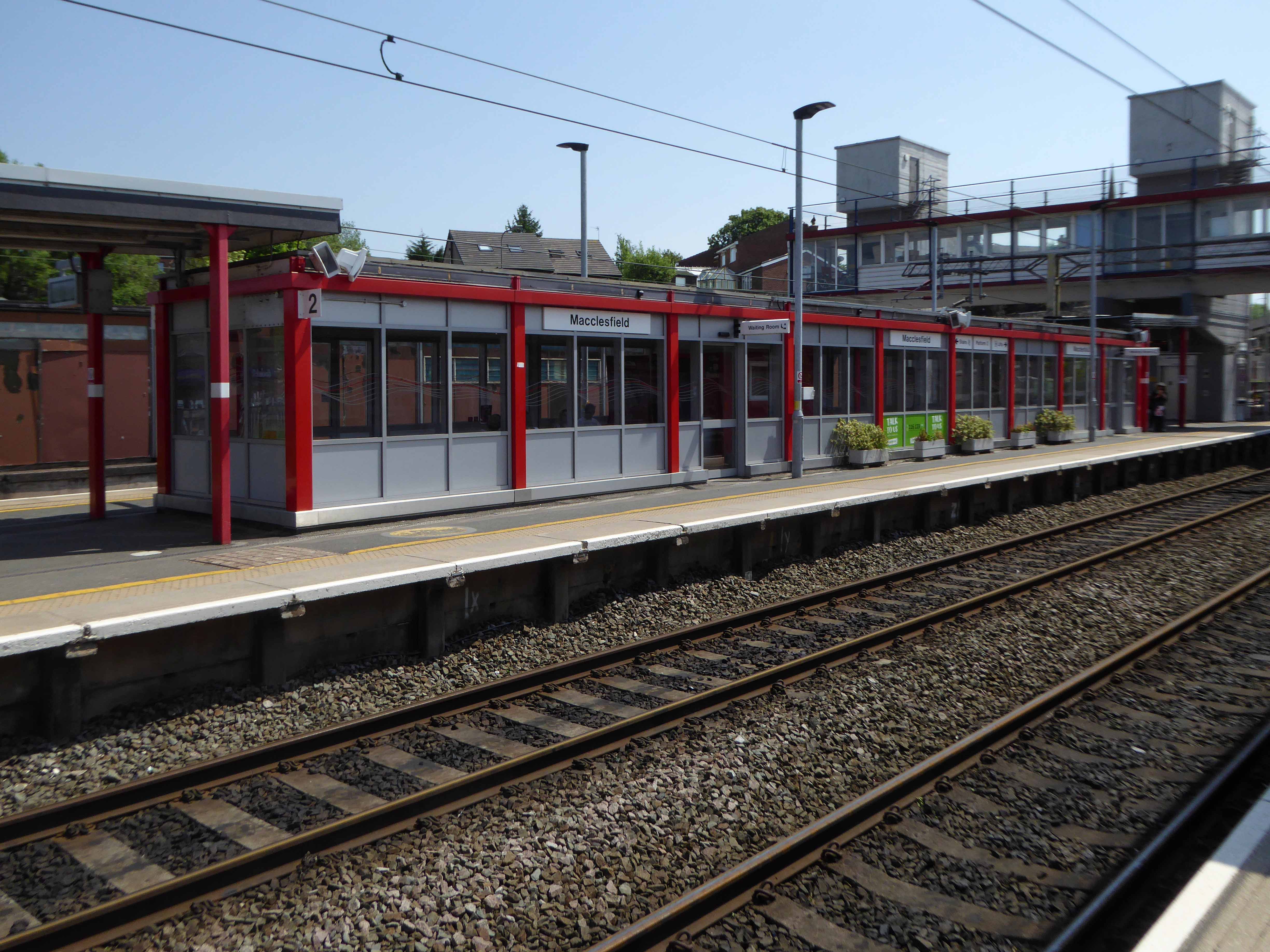
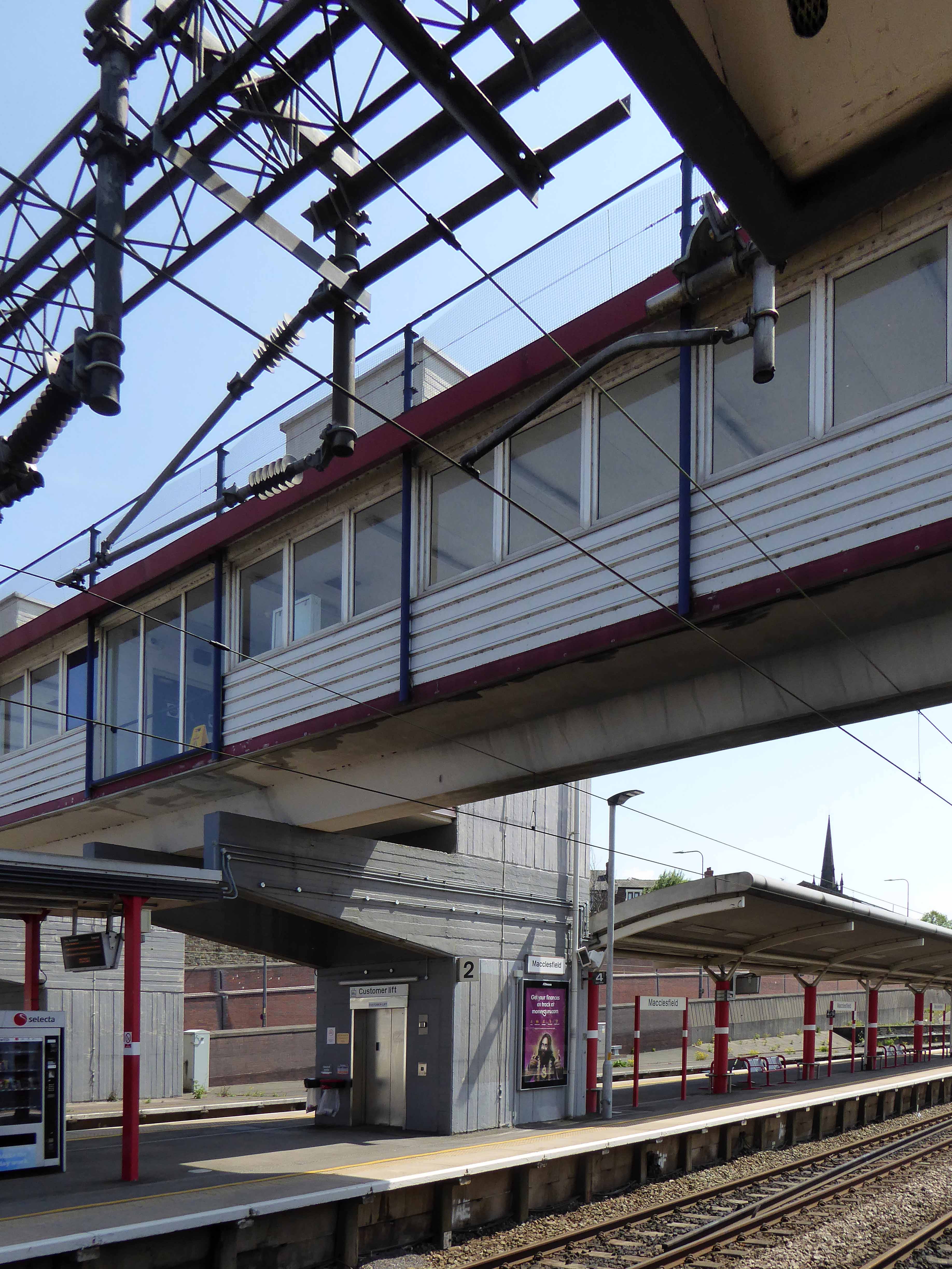
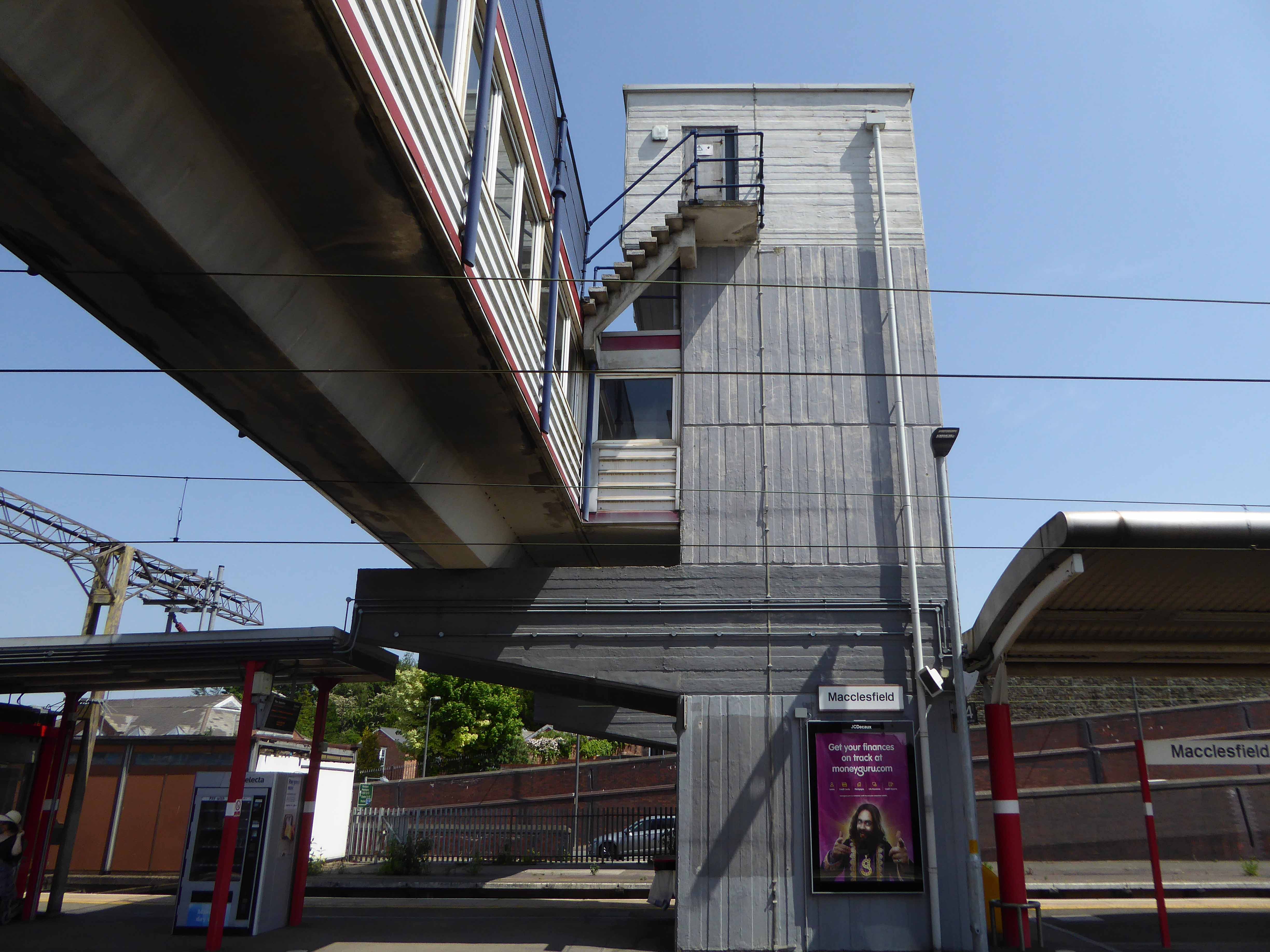
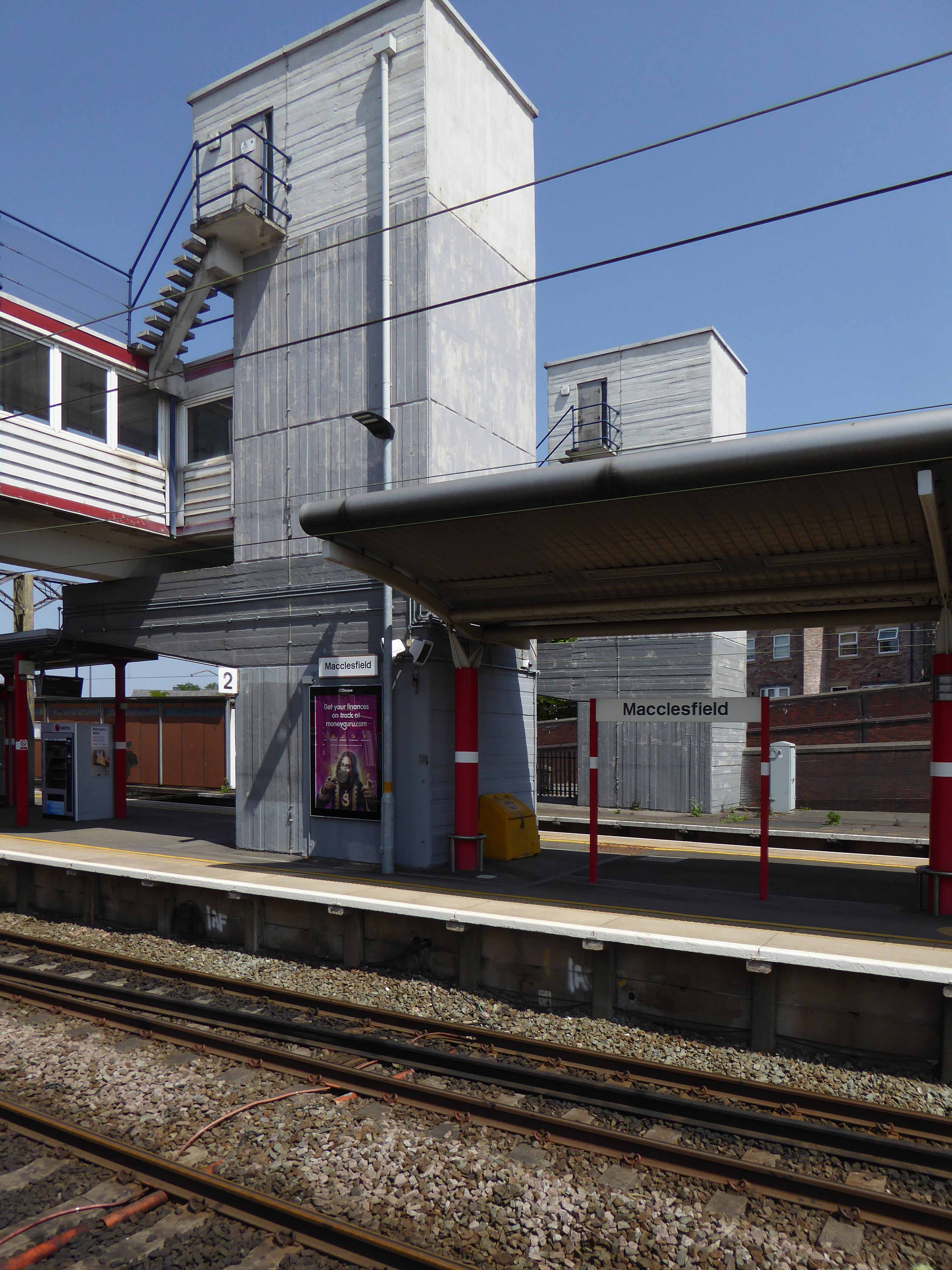
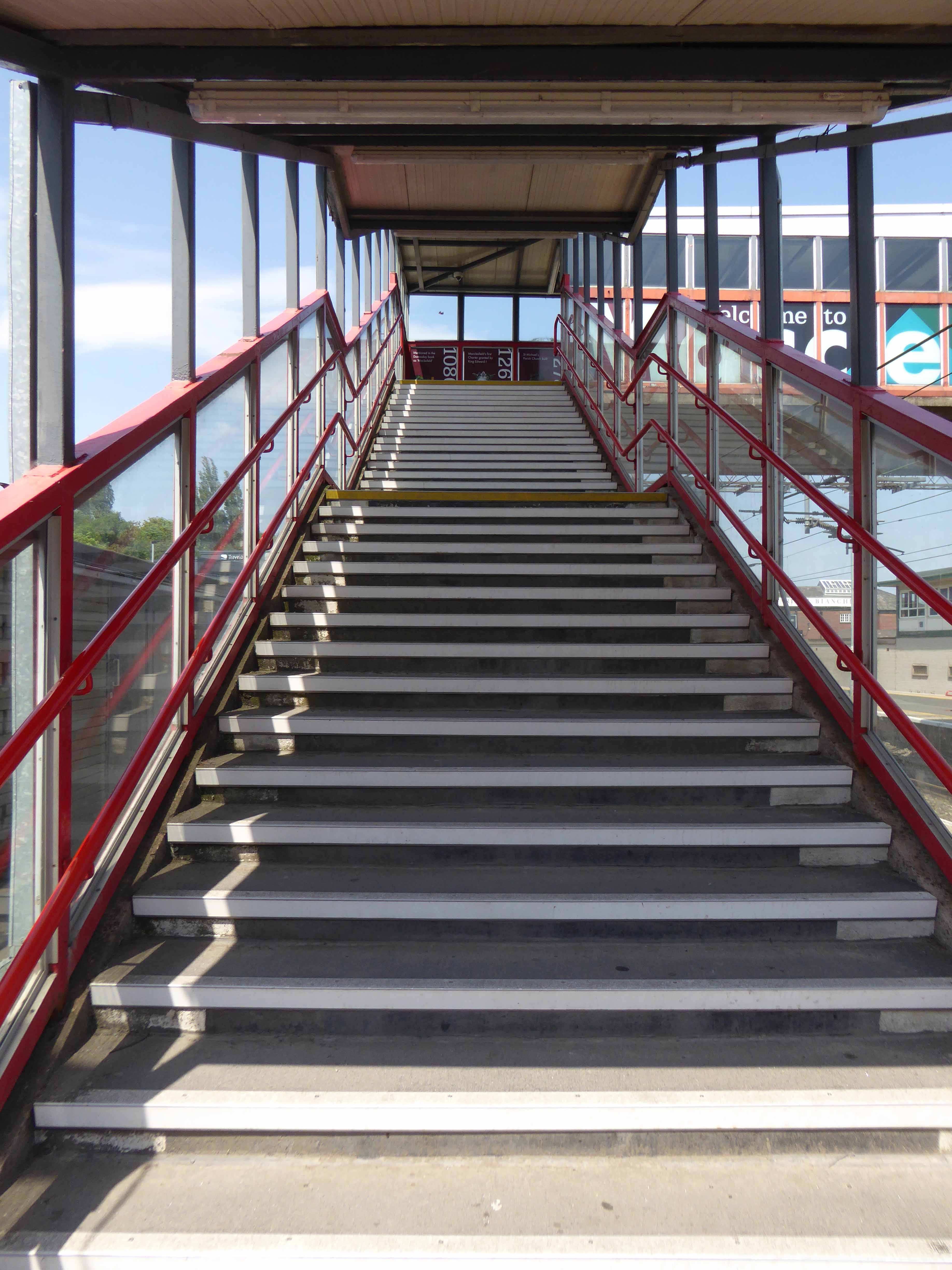
Though it seems to me that Macclesfield Station, in its earlier and current states, refuses to dovetail neatly into either of these sloppy binary paradigms.
The former – single storey buildings, fitting unostentatiously into the topographic and practical constraints of the site. A neat, tightly packed rhythm of brick arches with a compact and bijou porch welcoming the expectant traveller.
The latter a functionalist block, fully utilitarian crossings with lift access columns, embodying a particularly industrial demeanour.
From the golden age of steam to the moribund years of diesel, Macclesfield sits comfortably somewhere, betwixt and between ugly duckling and fully fledged swan.
Nestled in the lea of the East Cheshire Highlands, offering practical everyday transport solutions to the beleaguered commuter.
No frills, no thrills.
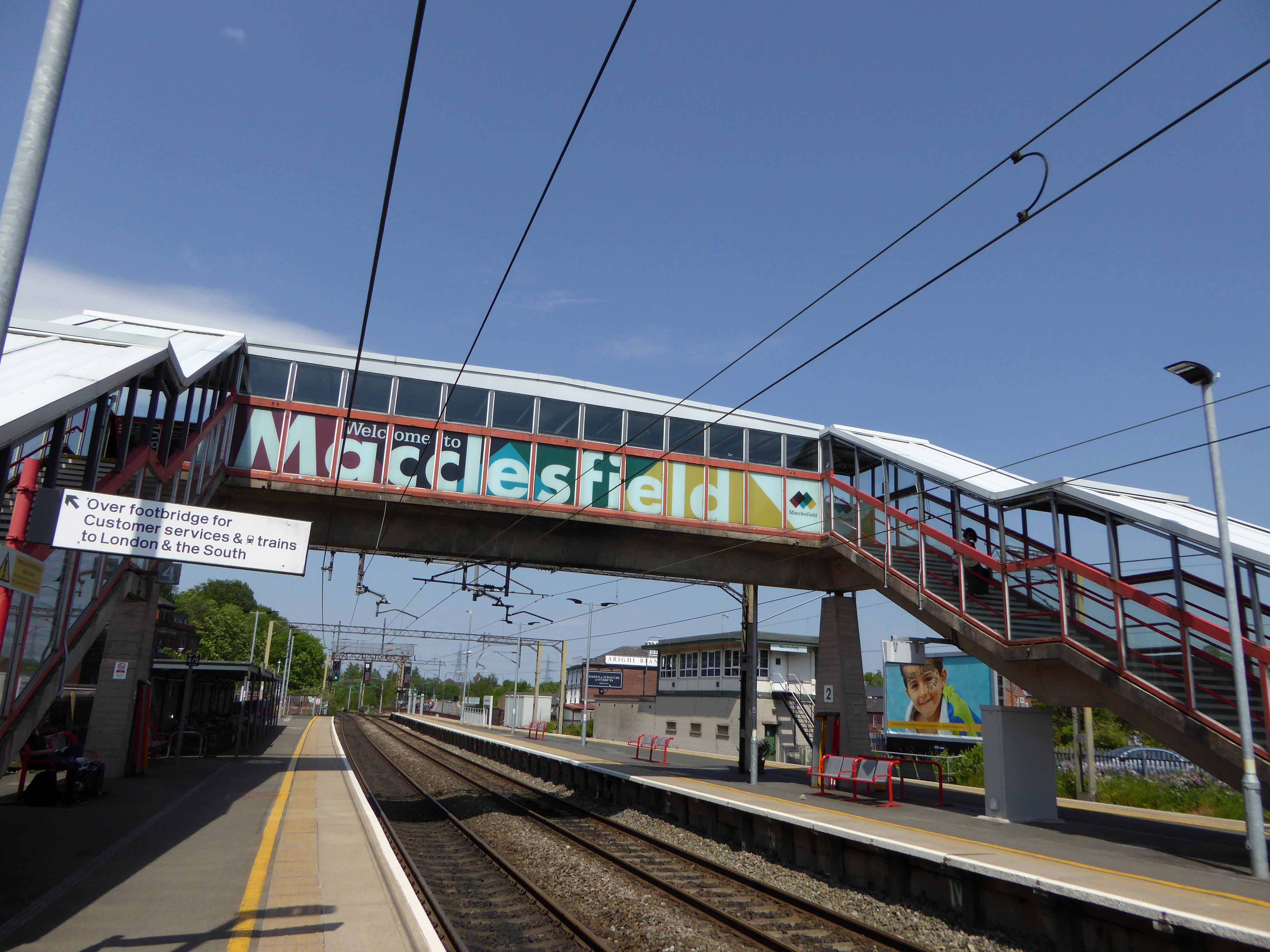
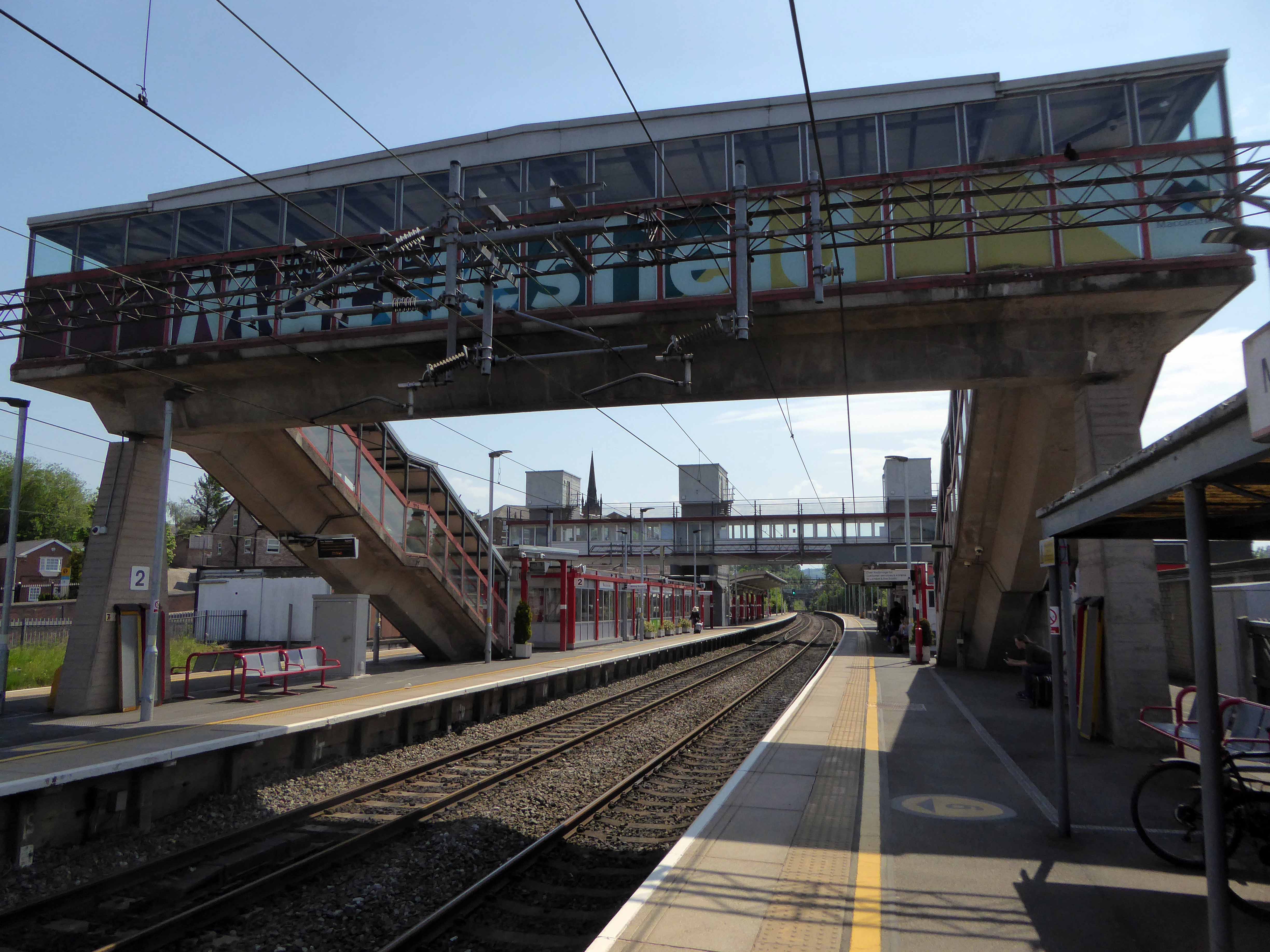
The London and North Western Railway opened the line between Manchester and Macclesfield on 19 June 1849 – Macclesfield Central was born. Later it would become a key station on the Stafford branch of the West Coast Main Line, remodelled in 1960 and rebranded as the much snappier Macclesfield Station.
Which it proudly announces topically and typographically to the world.
Welcome to Macclesfield a town that is clearly going places, and so are you.
The station won the Best Kept Station in Cheshire Award for 2007, but was reported in summer 2011 to be distinctly shabby, with peeling paintwork.
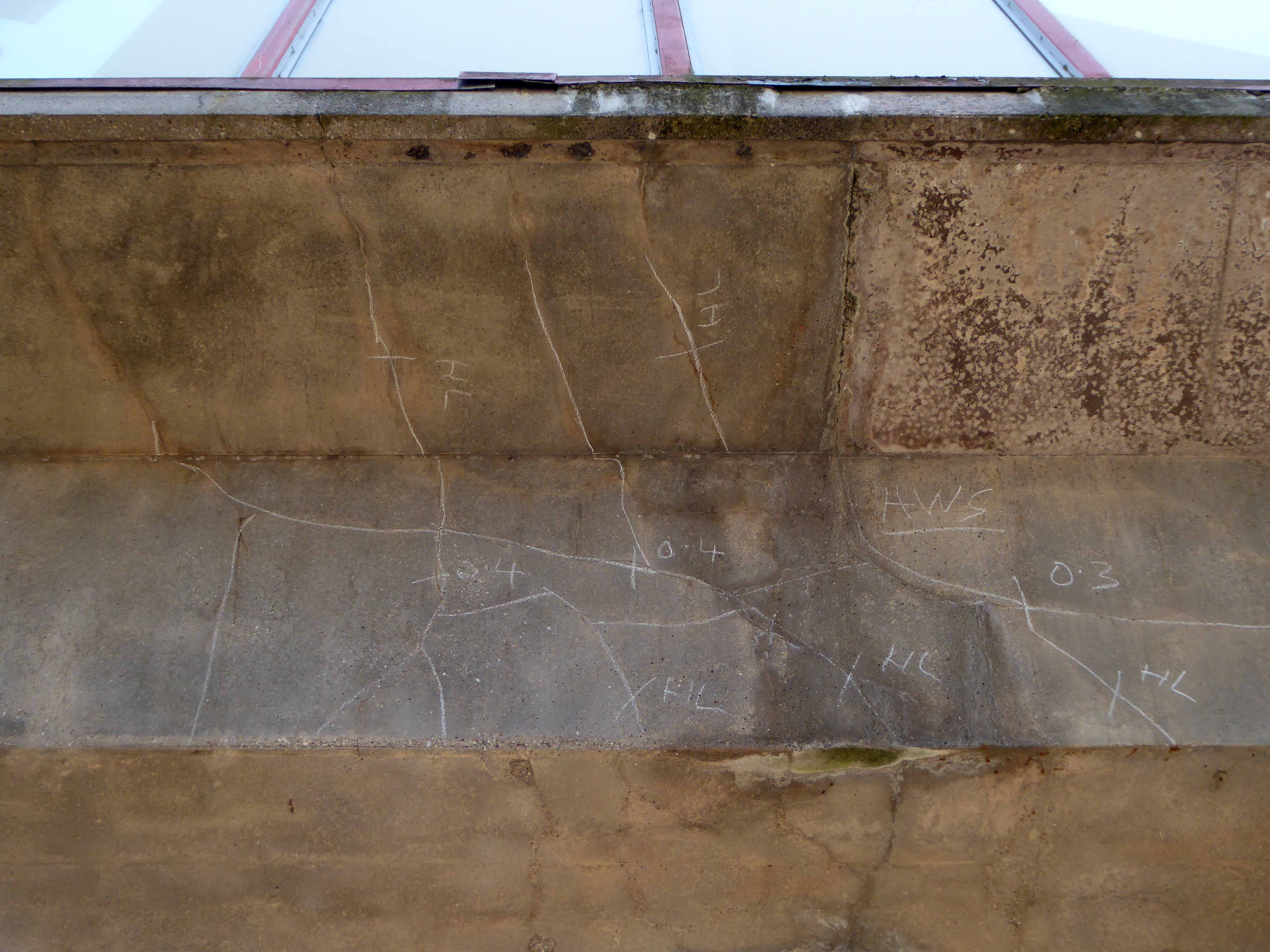
And yet there is something in the constituent Platonic steel, glass and concrete forms that never ceases to amuse and amaze me, this is Brutalism on a human and provincial scale.
The raw concrete softened with three or four shades of grey, as a concession to the delicate suburban sensibilities of this once silk-fuelled town.
Take a trip with me – join the Cheshire train set.
That which we call a brick, by any other name would smell as sweet.
Chancing across a written reference to the Marland Brick in the bookThe Trains Now Departed, I was slightly taken aback – from wither and whence it came and went.
I was aware of the my patronymic local connection:
This most interesting surname is of Anglo-Saxon origin, and is a locational name from Marland, a minor place in the parish of Rochdale, in Lancashire. The placename itself is composed of the Olde English elements “mere”, a lake, pool, and “land”, land.
However:
There are also places called Peters Marland in Devon, recorded as “Merland” in the Domesday Book of 1086 (the site of a church dedicated to St. Peter), and Marlands in Somerset.
So our southern cousins were clay-mongers, manufacturers of fine bricks to boot.
Marland Cream brickwork is a feature of North Devon. The hard cream bricks were made at Marland Moor by a succession of companies using stoneware ball clays dug from the Petrockstowe Basin.
Between Great Torrington and Hatherleigh, in north Devon, lie alluvial deposits of ball clay, a particularly useful clay which first found use for pottery and clay pipes in the seventeenth century. However the remoteness of the location prevented the growth of the industry and by the nineteenth century it only met local needs for pottery and bricks.
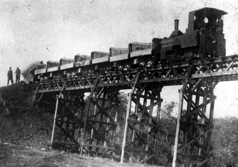
The impetus for the industry came, perhaps, with the opening of the London & South Western Railway to Torrington in 1872 for a few years later the owner of Clay Moor, William A. B. Wren, started to exploit his land. By 1877 he had sunk several pits and erected at the Marland Brick & Clay Works kilns, cottages and stables. Clay was being taken to Torrington station behind a traction engine but over six or so miles of poor quality roads this was not very efficient.
With the coming of the railway to Torrington, in 1881 a private mineral line was built to connect to the Marland area. This led to a great increase in production and was a factor in the opening in 1925 of the North Devon & Cornwall Junction Light railway, between Torrington and Halwill Junction, which superceded the mineral line. Closing to passengers in 1965, the section between Meeth and Barnstable remained open for freight, but by the 1980’s was moribund.
There are still remnants of the Marland Works Branch visible to this day.
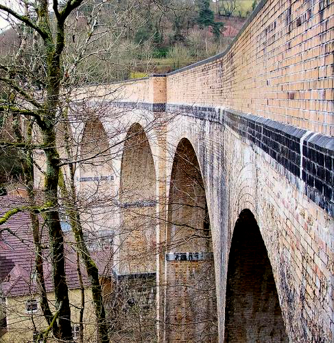
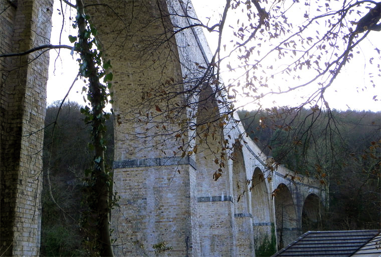
One of our famed family brick built achievements is the Chelfham Viaduct:
A railway viaduct built in 1896-97 to carry the Lynton and Barnstaple Railway across the Stoke Rivers valley. Designed by L&B engineer, FW Chanter, and containing over a quarter of a million Marland bricks, its eight arches – each 42 feet wide and 70 feet high – meaning that the 132-yard long viaduct is the largest narrow gauge railway structure in England.
The L&BR’s peak period came between 1902 and1913 when it carried almost 97,000 passengers a year. Yet the considerable endeavour invested in the railway was not enough to save it; as traffic dwindled, the line succumbed to closure by Southern Railways on 29th September 1935. Most of the trackbed and buildings were sold at auction in 1938. Although Chelfham Viaduct was retained, its parapets were taken down to about one foot above ballast level. In 1943, it featured in a film, The Flemish Farm, representing the Franco-Belgian border.
The structure was granted a Grade II listing on 25th February 1965. In 2000, in partnership with the Railway Heritage Trust and the Lynton & Barnstaple Railway Trust, British Railways Board completed a programme of remedial works.
Then later today, casting my mind back to my 2105 cycle tour from Weston Super Mare via Ilfracombe and Plymouth and onward to Hastings, I remembered a former chance encounter.
I had been here before, blissfully unaware of the local family connections along the Tarka Trail – thick as a Devon cream-tea coloured brick.
So when I eventually return to the area to fully explore our family heritage, I shall be sure to doff my cycling cap and smile whilst passing the warm cream expanses of Marland Brick.
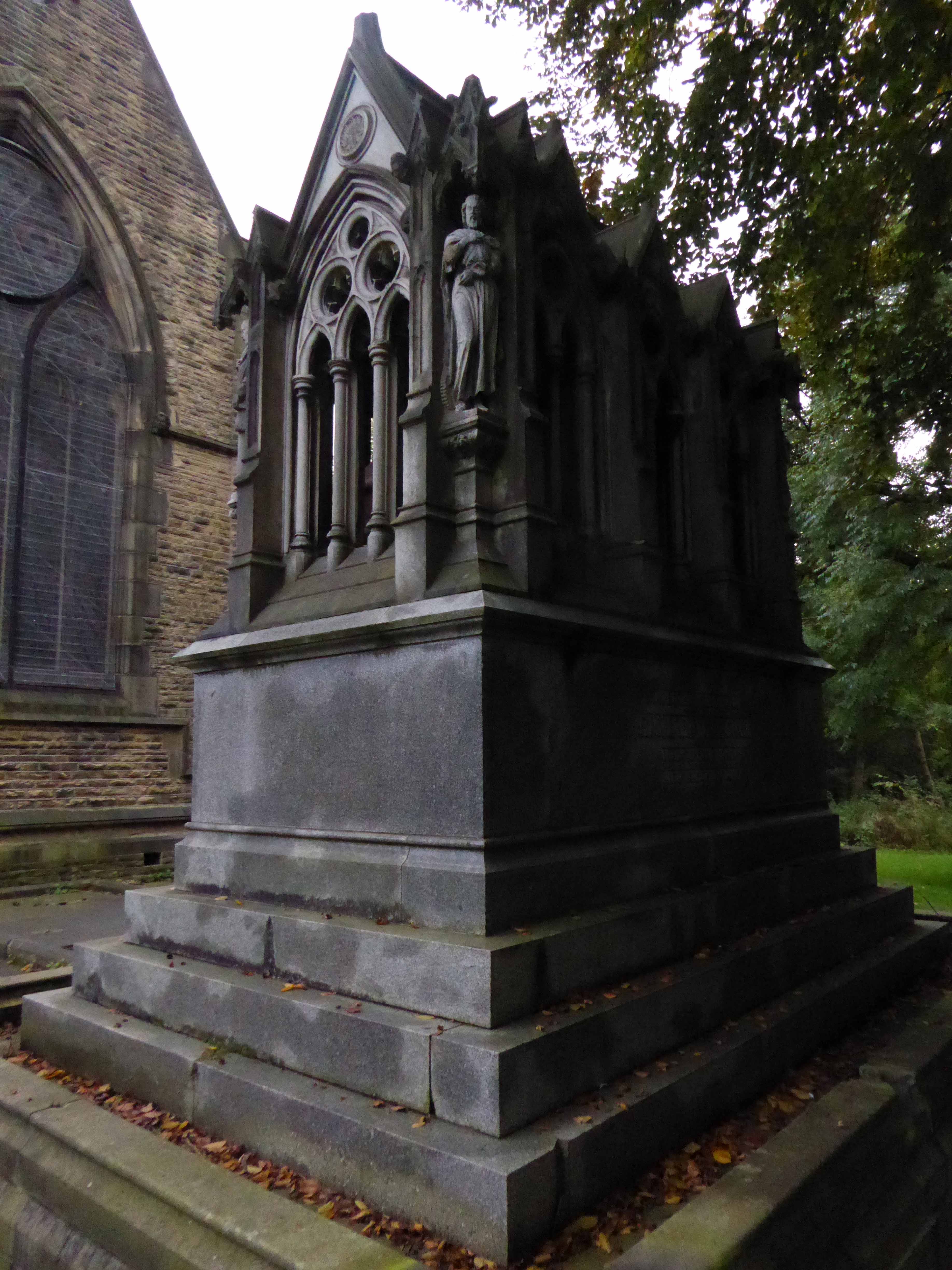
My journey begins here, at the Brookfield Unitarian Church, Hyde Road, Gorton, in search of the mausoleum of a man, who helped to shape the history of engineering, locomotion and Manchester.
Richard Peacock 9 April 1820 – 3 March 1889 was an English engineer, one of the founders of locomotive manufacturerBeyer-Peacock. Born in Swaledale, Richard Peacock was educated at Leeds Grammar School, but at 14 left to be apprenticed at Fenton, Murray and Jackson in Leeds.
At 18 Peacock was a precocious locomotive superintendent on the Leeds and Selby Railway. When the line was acquired by the York and North Midland Railway in 1840 he worked under Daniel Gooch at Swindon, but reputedly fled to escape Gooch’s wrath. In 1841, he became the Locomotive Superintendent of the Sheffield, Ashton-under-Lyne and Manchester Railway, subsequently the Manchester, Sheffield and Lincolnshire Railway from 1847. In this role he was responsible for founding the Gorton locomotive works for this railway, although he had left the firm shortly before they were completed in 1848.
In 1847 Peacock was present with Charles Beyer at a meeting at Lickey Incline which it is generally acknowledged gave birth to the Institution of Mechanical Engineers. George Stephenson was elected as first president and Charles Beyer as a vice president. Peacock became a member of the Institution of Civil Engineers in 1849.
In 1853, he joined Charles Beyer to found the celebrated locomotive company Beyer-Peacock. Peacock had originally met Beyer through the acquisition of locomotives from Sharp Brothers, and as mentioned earlier through both being among the founders of the Institution of Mechanical Engineers in 1847.
The locomotives designed and built in Gorton in their thousands were exported to the four corners of the globe, Manchester a confluence of capital and ingenuity, harnessing a workforce of millions, to produce a treasure trove of things and stuff
Shipping to Buenos Aires 1929
2 10 0 Locomotives bound for Turkey 1949
Last Diesels in the Paint Shop
By 1966 it was all over, the politically motivated, managed decline of manufacturing industry, a failure to adapt and compete, the loss of Empire, an increase in competition from other nations, all contributing to the almost inevitable, closing of the door.
The clang, hiss and controlled chaos of the boiler shop, just a faint, empty echo – listen.
There remains a legacy, the memories of all those men and women who laboured under those aching skylit eaves, millions of weary travellers world wide.
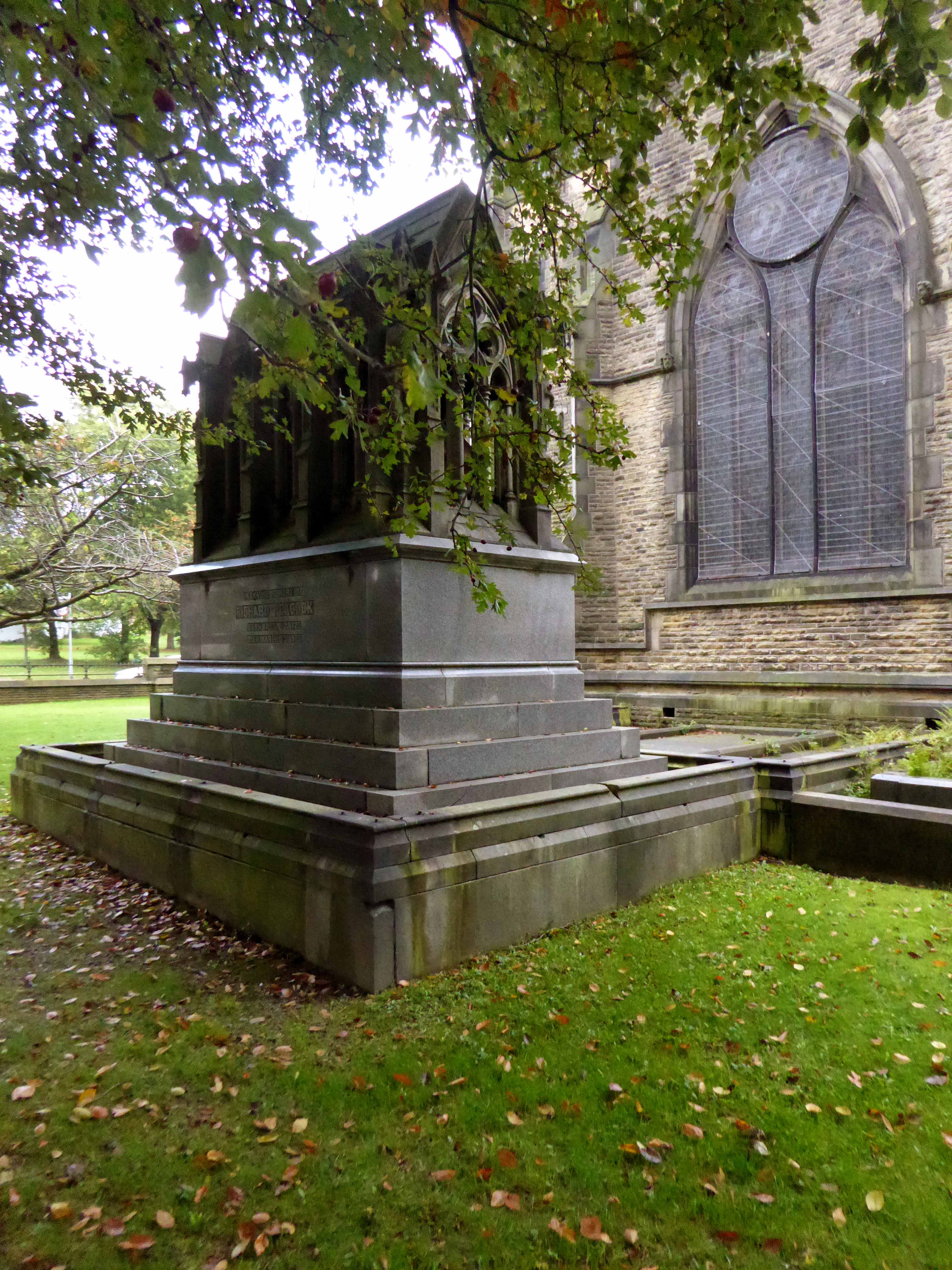
Not forgetting the church that Richard Peacock benevolently built, the mix of non-conformist worship, Liberal politics and philanthropy that informed Victorian Manchester, which still stands extant in stone, around our city.
Designed by Thomas Worthington in 1869-71, it has a six bay nave with north and south aisles. Arcade columns are of polished granite and wall faces are plaster lined with a large painting over the chancel arch. The roofs have been repaired but the interior has suffered from consequential water damage to the plasterwork which, at the time of visiting, was drying out. The church has been a victim of heritage crime.
Listed and left to the pressures of time tide, wind, rain and unwanted ingress.
Inset into the north wall of the church, facing onto Hyde Road – sculptor John Cassidy.
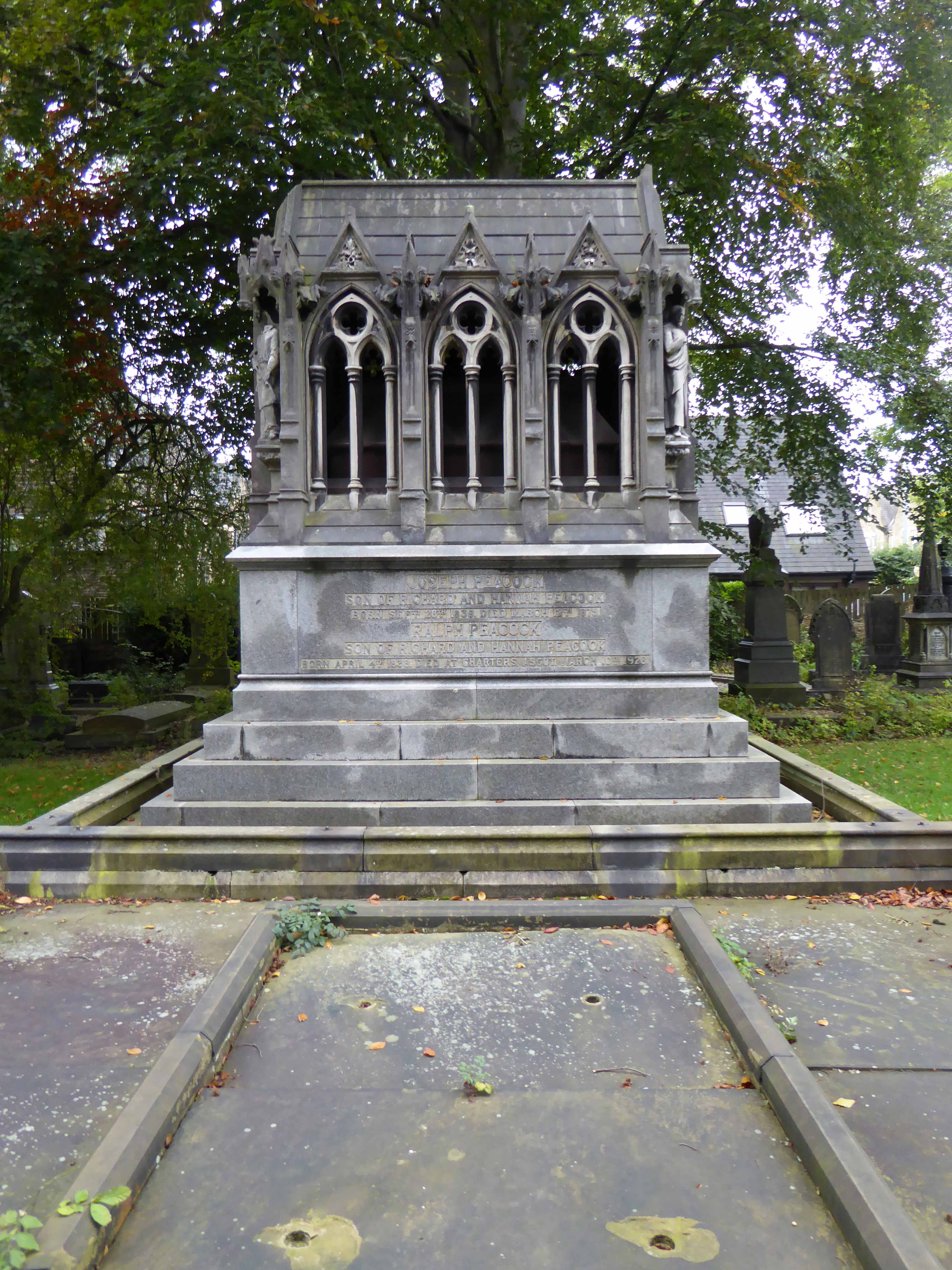
The Peacock Mausoleum is also the work of the church’s architect Thomas Worthington.
This sumptuous mausoleum takes the form of a Gothic shrine with a steeply pitched roof and arched openings filled with tracery and surmounted by gablets. The statues standing on slender pedestals at the four corners of the monument represent a Blacksmith, a Draughtsman, an Engineer and the architect himself. Further carved embellishments include head-stops, bats and twining ivy.
Condition – still sound, though the bronze angels that used to stand on the gables at either end were stolen some years ago in 1997.
So we arrive at the end of another journey through time and space and Gorton, the lives of so many long lone souls, bundled up in the graveyard of a now closed church, the fortunes won and lost eroded by the vagaries of the climate – economic and meteorological.
To begin at the beginning, well actually to begin in the middle and walk to the current beginning. The Gore Brook flows from the Lower Gorton Reservoir and from there onwards to meet the Chorlton Brook in the west, though I should imagine that prior to the construction of the waterworks, it was fed by more distant moorland waters.
Manchester being on the eastern edge of the Lancashire Plain and the western edge of the Pennines is riddled with rivers, rivers which now wriggle in an under and overground web, across heavily developed urban areas. Following the Industrial Revolution former meadow, common and farmland was overwritten by factories, housing and roads, the rural character of the rivers and brooks soon becoming darkened and polluted by the surrounding industries.
The Red Path is a pedestrian link between Pink Bank Lane and the Gorton boundary at Buckley Road. It roughly follows the course of Gore Brook. The original footpath, running from Buckley Road to the bank of the brook, was made using black cinders. It was probably made in the 1940s to provide access to the allotments located on either side. In the early 1950s , a concrete bridge was laid across Gore Brook and the footpath extended to Pink Bank Lane. This section used red bricks in it’s construction, probably supplied by Jacksons brickworks . Crushed bricks were then used as a topping to make the path smoother and fill in any cracks. The thoroughfare soon became known as the Red Path.
So wide eyed and mapless I bowled up at Brook Terrace, just off Stockport Road Longsight, in search of The Gore and its source.
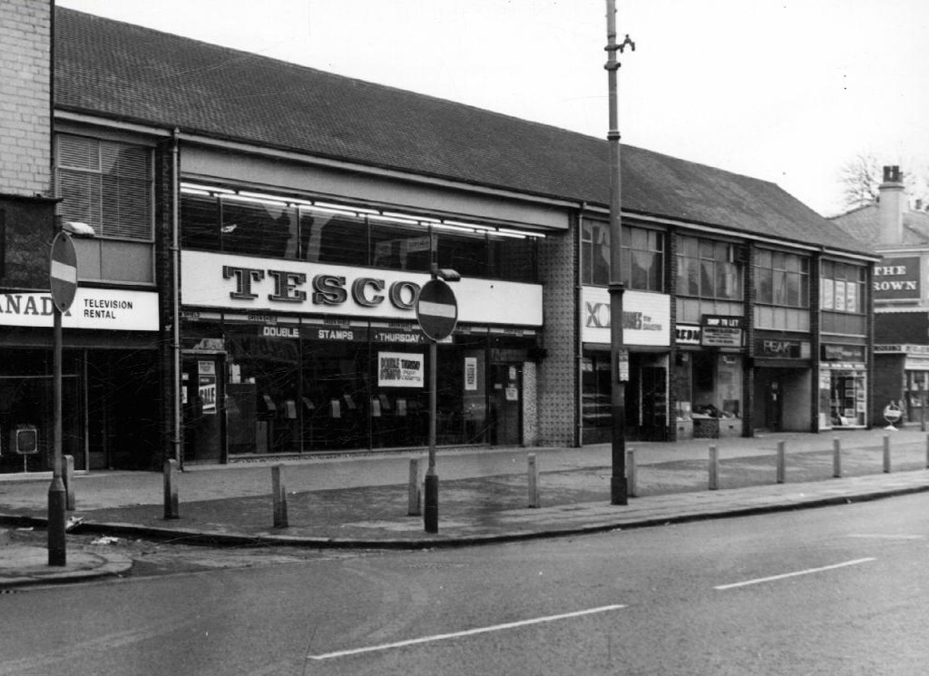
In the early 1900’s the river was still open and bridged, here at Stockport Road, later culverted and covered – anticipating the arrival of Tesco’s and Granada TV Rentals.
From there we pass under the railway along Brook Terrace and into Parry Road.
The underpass is still there and very much in use, as is Stanley Grove School – the Manchester Central Schools’ Kitchens are long gone, along with the food filled, insulated aluminium cases, that fed the hungry mouths of many, with semolina, pink custard, meat pies and lumpy mash.
Onwards to Elgar Street and still no sign of the river, hidden beneath our feet, the corner of Northmoor Road, can be seen on the corner, no longer distributing dividends, but now providing social housing.
We arrive at Pink Bank Lane, a rich mix of terraced homes, flats and factories – and the long lost Garratt, and the long lost Gore.
Though the lazy, lazy river has been confined in a brick lined wind, to meet the ever pressing needs of the Gorton Sewage Works.
The river then hugs the edge of Annie Lea Playing fields on Buckley Road, until it disappears again as it meets Mount Road, the playing fields are still open ground – the Manchester Cleansing Department, seen on the left – is no more.
Here on Knutsford Road we see the construction of the tunnels and culverts, the footbridge to the left spanning the railway, is still there.
1907
1911
1914
Finally we see The Gore reemerging clear, clean, wide, proud and resplendent in Sunny Brow Park, where it is still maintained as a decorative, duck-filled lake.
1907
1910
1964
Briefly underground again and into the back of Far Lane, skirting the Brookfield Church graveyard.
1920
1937
1964
Then tunnelling under Hyde Road at the back of the church lodge, appearing once again alongside Tan Yard Brow.
1904
1922
1964
The manmade waterfall continues to cascade, the Fairfield to Old Trafford railway is now the Fallowfield Loop, Manchester Cycleway, young lads no longer mess about in wellies and torn Tek Sac jeans on the bank, the Tannery no longer tans.
Then we end our journey by the broad expanse of the Lower Gorton Reservoir, implausibly dotted with jolly yachts, and home to a now absent stepped outflow stream. Look up to the east, and there you’ll see the moors, you could go further.
The station was originally built as Store Street Station by the Manchester and Birmingham Railway in 1842, before being renamed London Road Station in 1847. It was shared by the Sheffield, Ashton-under-Lyne & Manchester Railway and it has been rebuilt and added to a number of times, with two news spans added to the train shed roof in 1881 and island platforms added linking to Manchester Oxford Road in 1882 (replacing two old Manchester, South Junction and Altrincham Railway platforms which were built next to the station).
An imposing classical façade with a substantial cast iron and glass train shed, the approach sloping up to the frontage, as of necessity the line entered the city on a raised trackbed.
Initially the approach was lined with railway warehousing, subsequently demolished to make way for the redevelopments of the 1960s.
Detailed plans are made to reshape the station concourse and entrance.
Dreams are turned into reality, as near as makes no difference.
The newly electrified lines opening up the city to a world of high speed intercity travel.
The Krays it seems were deemed to be unwelcome visitors, everyone else came and went, met with equanimity and a bright new modernist vista.
The brand new shiny buffet replaces the archaic dining rooms, as Brylcreemed, bow tied and moustachioed waiters are consigned to the scrapheap of history.
Likewise the gloomy destination boards – out with the old!
And in with the new.
We have a fully integrated modern interior to deal with the modern passengers’ every need – including crystal clear signage, seating and bins.
Stars of screen and stage are guided through with consummate ease, Margot Fonteyn and Rudolf Nureyev in his brand new baby seal skin coat arrive in 1968 to dance Swan Lake at the Palace.
Esteemed footballer Eusebio on his travels during the 1966 World Cup.
In 1969 Gateway House arrives, Richard Sieffert & Partners wavy hello and goodbye to Manchester’s premier railway station.
Piccadilly has now seen several revamps, the concourse an exercise in contemporary cluttered retail/airport chic, a 125mph Pendolino journey away from the carefully considered internal order of yesteryear.
Who knows what the future holds?
HS2 to name but one – sit back let the train take the strain.
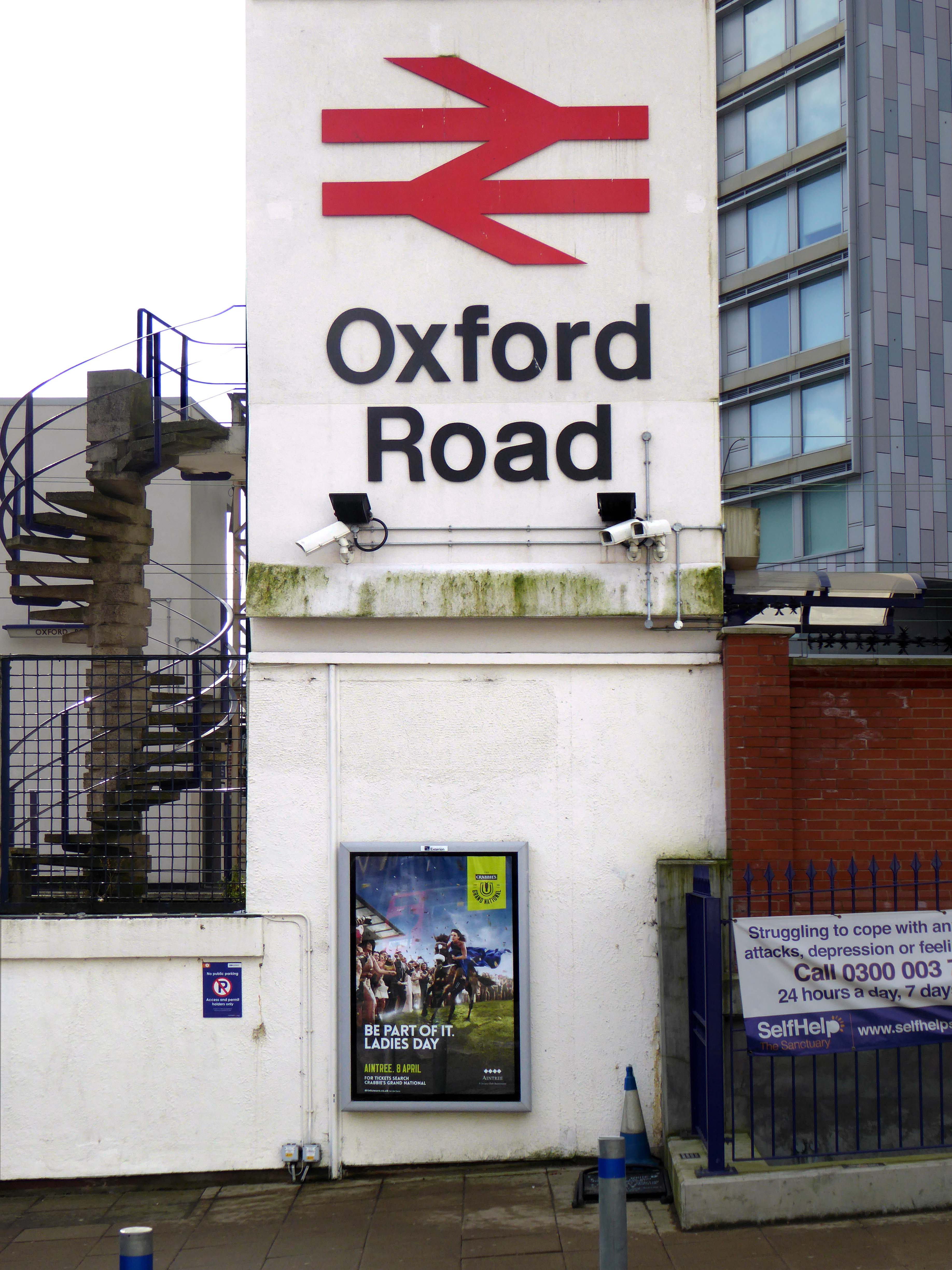
Possibly on the way to somewhere else, stranded at Oxford Road Station.
Tucked in behind Shaw’s Furniture and The Tatler Cinema.
I love every curvy corner, timber frame and canopy, concrete spiral, empty kiosk and precipitous steps – I’m happy to be stranded.
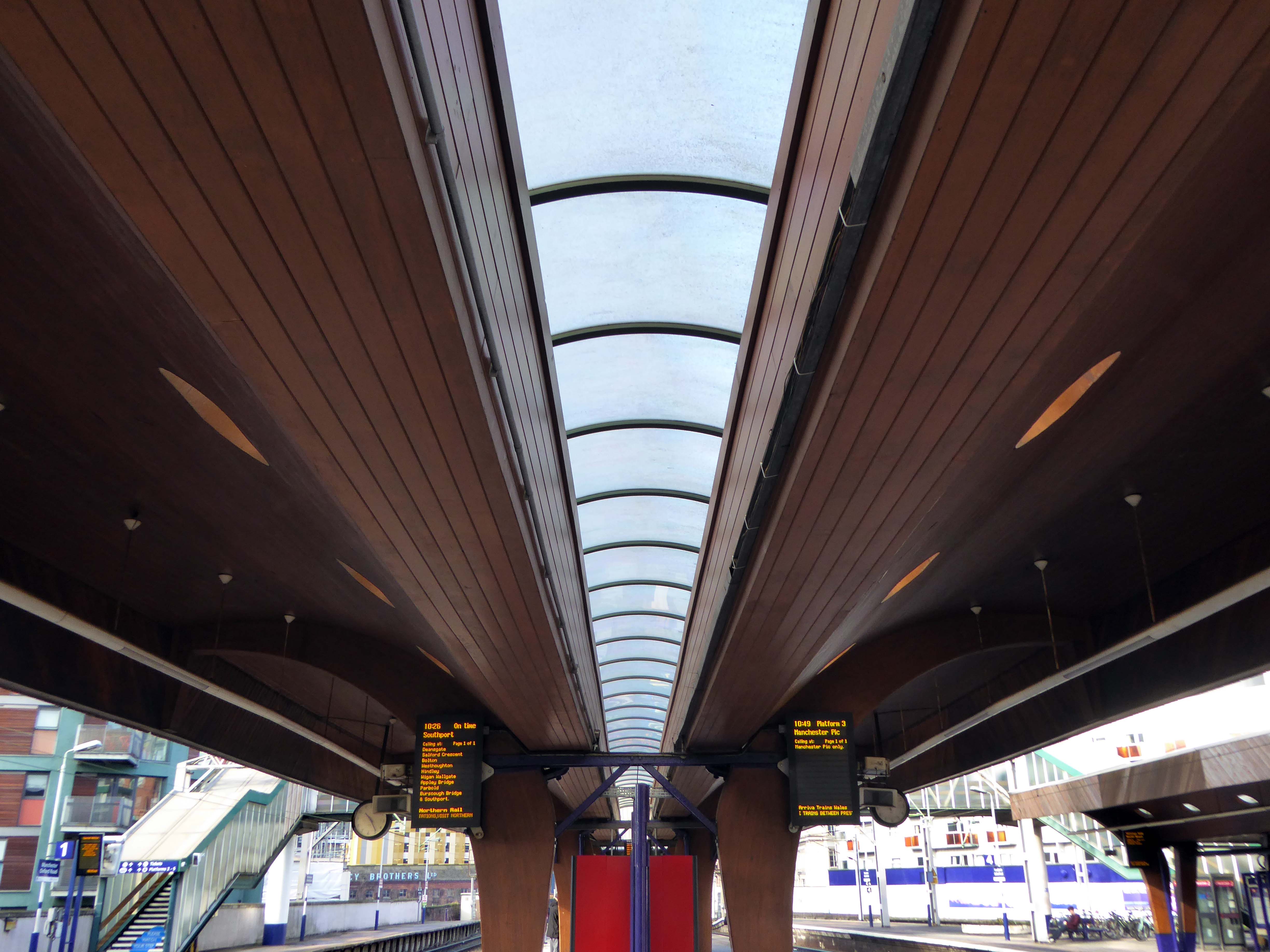
It opened in 1849 and was rebuilt in 1960.
The station was opened as Oxford Road on 20 July 1849 by the Manchester, South Junction and Altrincham Railway . The station was the headquarters of the MSJAR from its opening until 1904. It had two platforms and two sidings, with temporary wooden buildings. To allow for extra trains in connection with the Manchester Art Treasures Exhibition in 1857, extra platforms and sidings were built. In 1874 the station was completely rebuilt providing two bay platforms and three through platforms. Further reconstruction took place during 1903-04. From 1931 it was served by the MSJAR’s 1500V DC electric trains between Altrincham and Manchester Piccadilly.
The station had become dilapidated by the 1950s, and in connection with the electrification and modernisation programme of the Manchester to London line in 1960, the old buildings were replaced by the current structure by architects W.R. Headley and Max Glendinning and structural engineer Hugh Tottenham. It was designed in a distinctive style in concrete and wood with curves bringing to mind the Sydney Opera House.
Use of the station increased from May 1988 when the Windsor Link was inaugurated between Deansgate and Salford Crescent, connecting lines to the north and south of Manchester.
The station is a grade II listed building.
One of the most interesting and innovative buildings of the period, the most ambitious example in this country of timber conoid shell roofing.