Heat lingers in the Northwest U.S. as widespread excessive heat warnings and heat advisories continue. Organized areas of monsoonal showers and thunderstorms may result in flooding across the Southwest and Four Corners. Flooding from heavy rain and thunderstorms is also possible from the Mid South to the Mid-Atlantic along a stalled front. Fire weather conditions across Hawaii and the Western U.S.
Read More >
Deletion of Valdez-Cordova Census Area and Federal Information Processing Standards (FIPS) Code and
Addition of Chugach Census Area and Copper River Census Area with New FIPS Codes,
This change has taken place for NWS Products, Services, and Systems.
See PNS22-15
NOAA WEATHER RADIO ALL HAZARDS
NOAA Weather Radio All Hazards (NWR) is a nationwide network of radio stations broadcasting continuous weather information directly from the nearest National Weather Service office. NWR broadcasts official Weather Service warnings, watches, forecasts and other hazard information 24 hours a day, 7 days a week.
Working with the Federal Communication Commission's (FCC) Emergency Alert System , NWR is an "All Hazards" radio network, making it your single source for comprehensive weather and emergency information. In conjunction with Federal, State, and Local Emergency Managers and other public officials, NWR also broadcasts warning and post-event information for all types of hazards – including natural (such as earthquakes or avalanches), environmental (such as chemical releases or oil spills), and public safety (such as AMBER alerts or 911 Telephone outages).
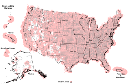
Known as the "Voice of NOAA's National Weather Service," NWR is provided as a public service by the National Oceanic and Atmospheric Administration (NOAA), part of the Department of Commerce. NWR includes more than 1000 transmitters, covering all 50 states, adjacent coastal waters, Puerto Rico, the U.S. Virgin Islands, and the U.S. Pacific Territories. NWR requires a special radio receiver or scanner capable of picking up the signal. Broadcasts are found in the VHF public service band at these seven frequencies (MHz):
162.400
162.425
162.450
162.475
162.500
162.525
162.550
Special Notices
Click on [+] to see more [-] to see less
[+] "Beeping" on certain Midland receivers and the weekly test
NOTE: If your Midland receiver is beeping, the following explanation is the most common, but it is not the ONLY explanation for a beeping receiver.
The Midland WR-120 desktop NOAA weather radio knows it is supposed to receive a weekly test from the National Weather Service every seven days. If the radio goes for ten days without receiving a test, it gives out one beep every ten minutes.
The radio will re-set itself at the next weekly test, or the next watch/warning issuance.
If you do not want to wait, you can cancel the beeping by unplugging the radio from the wall, turning the radio over, and removing one battery. Wait approximately 10-15 seconds, then replace the battery and plug the radio back in. The settings on the radio will NOT be affected by this, as the SAME county code, and all other information is stored on a flash memory chip.
But you WILL need to re-set the clock. To do so:
1) Push MENU. "SET TIME" appears.
2) Push SELECT
3) Use the up/down arrows to adjust the hour up or down. To get from AM to PM, just continue past the hour 12.
4) Use the right button to move to the minutes setting
5) Use the up/down arrows to adjust the minutes up or down. Right arrow to access both of the minute digits.
6) When you have set the clock to the proper time, hit MENU twice. The radio will display "SAVING". You are done setting the clock.
We apologize for the inconvenience. The ten-day missed test alarm is a way to assure viewers that their weather radio is performing properly.
NOTE: The previous version of this radio, the Midland WR-100 does not make an audible beep. However, it will display the words "CHECK RECEPTION" until it is re-set using the same steps as outlined above. Like the WR-120, the radio will automatically re-set itself at the next weekly test, or the next watch/warning issuance.
[+] WXM26 Pierre, SD is out of service (7/29/2022)
(7/29/2022) WXM26 Pierre, SD on the frequency 162.400 is out of service due to the tower being replaced. We do not have an estimated time for a return to normal service.
Listeners are advised to check the NOAA Weather Radio County Coverage Listings for alternate transmitters serving their county. We apologize for the inconvenience and thank you for your patience.
[+] WXN29 Call Hill, NY is out of service (6/28/2022)
(6/28/2022) WXN29 Call Hill, NY on the frequency 162.425 is out of service due to antenna damage. We do not have an estimated time for a return to normal service.
Listeners are advised to check the NOAA Weather Radio County Coverage Listings for alternate transmitters serving their county. We apologize for the inconvenience and thank you for your patience.
(3/24/2022) WWG76 Kulani Cone, HI transmitter on frequency 162.550 MHz is degraded due to limited coverage caused by antenna damage. We do not have an estimated time for a return to normal service.
Listeners are advised to check the NOAA Weather Radio County Coverage Listings for alternate transmitters serving their county. We apologize for the inconvenience and thank you for your patience.
[+] WZ2540 North Kohala, HI is degraded (3/24/2022)
(3/24/2022) WZ2540 North Kohala, HI transmitter on frequency 162.500 MHz is degraded due to limited coverage caused by antenna damage. We do not have an estimated time for a return to normal service.
Listeners are advised to check the NOAA Weather Radio County Coverage Listings for alternate transmitters serving their county. We apologize for the inconvenience and thank you for your patience.
(3/24/2022) WWF39 Hawaii Kai, HI transmitter on frequency 162.425 MHz is degraded due to limited coverage caused by antenna damage. We do not have an estimated time for a return to normal service.
Listeners are advised to check the NOAA Weather Radio County Coverage Listings for alternate transmitters serving their county. We apologize for the inconvenience and thank you for your patience.
[+] WWF37 Carlsbad, NM transmitter is out of service (2/11/22)
(2/11/2022) WWF37 Carlsbad, NM on the frequency 162.475 is out of service due to an inoperable transmitter. We do not have an estimated time for a return to normal service.
Listeners are advised to check the NOAA Weather Radio County Coverage Listings for alternate transmitters serving their county. We apologize for the inconvenience and thank you for your patience.
[+] WXN24 Artesia, NM transmitter is Out of Service (1/19/22)
(1/19/2022) WXN24 Artesia, NM on the frequency 162.425 is out of service due to a transmitter power issue. We do not have an estimated time for a return to normal service.
Listeners are advised to check the NOAA Weather Radio County Coverage Listings for alternate transmitters serving their county. We apologize for the inconvenience and thank you for your patience.
[+] Multiple Alaska transmitters are Out of Service (7/6/22)
(7/6/2022) WNG529 Cape Gull, AK on the frequency 162.500 is out of service.
We do not have an estimated time for a return to normal service.
Listeners are advised to check the NOAA Weather Radio County Coverage Listings for alternate transmitters. We apologize for the inconvenience and thank you for your patience.
((01/24/2022) KZZ88 Cape Fanshaw, AK transmitter on frequency 162.425 MHz is out of service. We do not have an estimated time for a return to service.
Listeners are advised to check the https://www.weather.gov/NWR/outages page for updates. We apologize for the inconvenience and thank you for your patience.
(01/12/2022) WNG718 Sitkinak Dome, AK transmitter on frequency 162.450 MHz is out of service. We do not have an estimated time for a return to service.
Listeners are advised to check the https://www.weather.gov/NWR/outages page for updates. We apologize for the inconvenience and thank you for your patience.
[+] WNG728 Bellflower, MO transmitter is Out of Service (07/16/21)
(7/16/2021) WNG728 Bellflower, MO on frequency 162.425 is currently in the process of being moved to another tower. We do not have an estimated date for a return to service.
Listeners are advised to check the NOAA Weather Radio County Coverage Listings for alternate transmitters serving their county. We apologize for the inconvenience and thank you for your patience.
NWR Stations that have either degraded
performance or are currently offline.
This information was current on:
Legend
DEGRADED - Indicates that a transmitter is operational but experiencing a temporary reduction in the quality of service such as coverage area, audio quality, etc.
OUT OF SERVICE - Indicates transmitter is temporarily non operational due to problems such as a power outage, antenna damage, etc.

 NOAA Weather Radio All Hazards (NWR) is a nationwide network of radio stations broadcasting continuous weather information directly from the nearest National Weather Service office. NWR broadcasts official Weather Service warnings, watches, forecasts and other hazard information 24 hours a day, 7 days a week.