

Understand the difference between a Watch and a Warning. If a Flood or Flash Flood WARNING is issued, move to higher ground, and never drive through a flooded road! #COwx

Follow
National Weather Service
@NWS
National Weather Service’s Tweets


Sioux Falls needed and wished for some rain this summer.
We received the most rain in one day ever this morning!
5.41 inches is now the big number to beat for a single day rainfall on August 7th, the month of August, or on any date.

17
43


[7-day Temperature Forecast 🌡️] An upper-level high will progress thru the Central Rockies into the Northern/Central Plains this week, leading to hot temps (10-15F above average) over these regions, while an incoming cold front may bring slightly below normal highs further east.

GIF
2
18
47

What are the biggest weather hazards this season? Visit our Summer Safety website to get prepared and become Weather-Ready: weather.gov/wrn/summer-saf

1
6
20

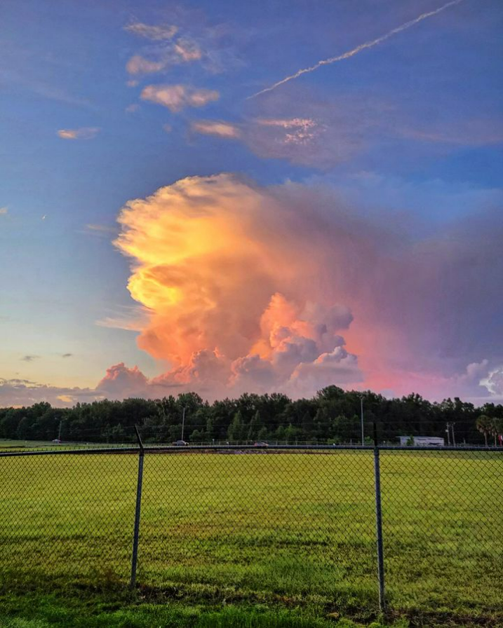
⛈ View of the storms sliding across Mobile Bay and the Mississippi Sound around sunrise this morning from our office in west Mobile. #mobwx
read image description
ALT
1
28
153
Topics to follow
Sign up to get Tweets about the Topics you follow in your Home timeline.
Carousel
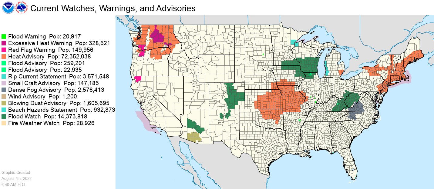
Nearly 73 million people are under heat related products today, from the central Plains to the Great Lakes and Northeast and in the Northwest. Meanwhile, just over 14 million are under flood watches with the most susceptible area for flooding being the Upper Mississippi Valley.
5
30
50
Heavy rain is likely to produce areas of flash flooding across portions of the Midwest today, with impacts already ongoing early this morning. Additional rounds of thunderstorms are possible through tonight. #TurnAroundDontDrown

read image description
ALT

read image description
ALT
2
38
66
A MODERATE risk is in effect in our Day 1 Excessive Rainfall Outlook. More details: go.usa.gov/cu3Dw

21
71


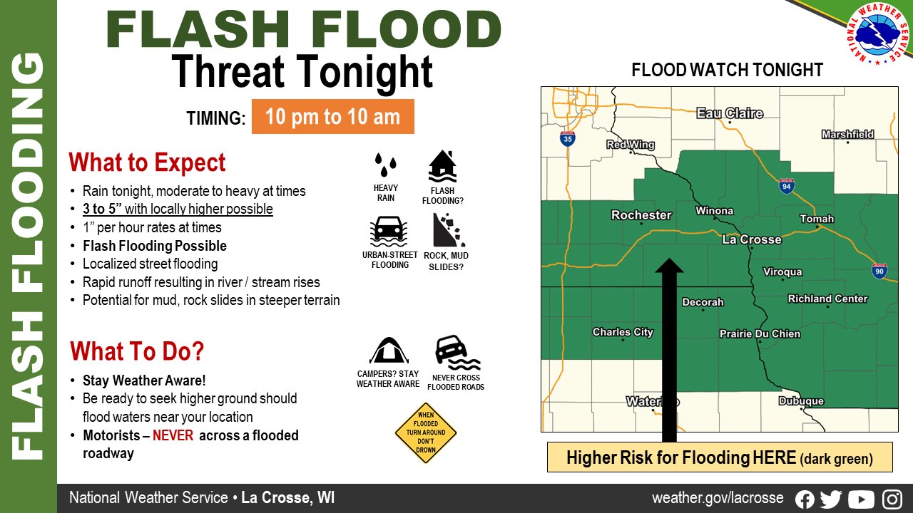
#HeavyRain tonight will lead to urban-street flooding, and if it repeats in areas, potentially flash #flooding. 3-5" expected for some, could be more. Outdoor plans and/or camping tonight? Be ready to seek higher ground if flooding is realized in your location. #mnwx #iawx #wiwx
12
27
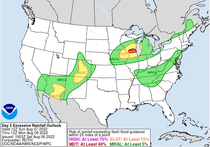
A MODERATE risk is in effect in our Day 2 Excessive Rainfall Outlook. More details: go.usa.gov/cu3Dw
34
80


2 pm EDT Aug 6: A tropical wave is forecast to move off the west coast of Africa tonight or early Sunday. Gradual development of the wave is possible while it moves westward across the eastern and central tropical Atlantic through the middle of next week.
nhc.noaa.gov/gtwo.php?basin


33
300
571
Slow moving showers and thunderstorms will continue to
develop across the Appalachians this afternoon and evening. These
storms will be slow moving and contain rain rates of 1-2"/hr.
Flash flooding is possible.
Quote Tweet
#WPC_MD 0692 affecting Southern and Central Appalachians, #mdwx #wvwx #vawx #pawx #ncwx #tnwx #scwx #gawx, go.usa.gov/xS7CX

3
14
29

8/6/22 - Isolated heavy rainfall and flash flooding may occur today across parts of New Mexico and southeast Texas. The heavy rainfall threat will continue across New Mexico on Sunday and persist into the upcoming week.

1
6
18
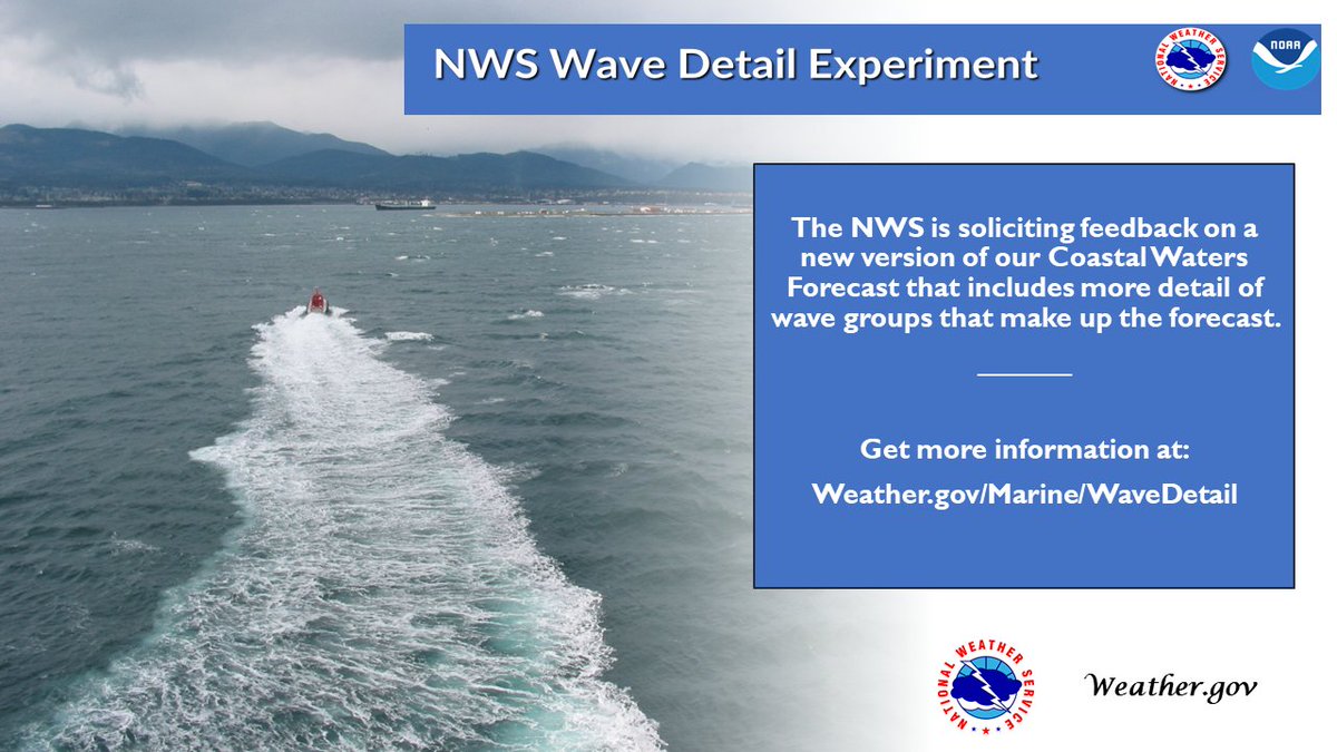
Checking the forecast before you leave shore is the first step to preparing for a day on the water. The new Wave Detail Experiment from the NWS offers mariners more insight into current and forecasted sea state conditions. Check it out now at weather.gov/marine/wavedet

read image description
ALT
2
13
35
Showers and thunderstorms will continue to train from west to east across the Ohio Valley through the afternoon with rainfall rates of 1-2"/hr. This could produce an additional 2-3" of rainfall with locally higher amounts. Flash flooding is likely.
Quote Tweet
#WPC_MD 0691 affecting Ohio Valley, #pawx #wvwx #ohwx #vawx #kywx #tnwx #inwx, go.usa.gov/xSGhe

1
8
28
Intensifying thunderstorms will
move towards the Minneapolis metro area this morning. Rainfall
rates in excess of 2"/hr are likely, which through training could
produce 2-3" of rain with locally higher amounts. Isolated flash
flooding is possible.
Quote Tweet
#WPC_MD 0690 affecting Portions of the Upper Midwest, #wiwx #mnwx #iawx #sdwx, go.usa.gov/xSGuy

4
9
35
Dangerous summer heat is expected in portions of the Plains to the Great Lakes, the Northeast, and the Northwest. Thunderstorms and heavy rains may produce flash flooding in the Southwest and Southern Rockies, the Central Plains to Upper Midwest, and the Southern Appalachians.

read image description
ALT
4
29
84
8 am EDT Aug 6: A tropical wave is forecast to move off the west coast of Africa this weekend. Some gradual development is possible while the system moves westward across the eastern and central tropical Atlantic through the middle part of next week.
nhc.noaa.gov/gtwo.php?basin

54
428
942
Here's the high temperature forecast and the departure from normal on Saturday. A cold front will cut through the Upper Midwest and out ahead of it will be hot conditions from the south-central Plains to the Great Lakes and Northeast, while behind the front it will feel like Fall

3
27
69

A severe thunderstorm watch has been issued for parts of Minnesota, North Dakota and South Dakota until 12 AM CDT

read image description
ALT
1
14
40


After dangerously hot temperatures today, the northern plains will see relief this weekend behind a cold front. For example, Cheyenne, WY's Warren AFB is forecast to tie the daily high record temp of 94°F today - and drop to a high of only 74°F by Sunday! weather.gov

GIF
7
24
78

What do we do when we want to "see" the wind from space? Review the Derived Motion Wind (DMW) vectors of course!
This #FullDiskFriday imagery from #GOESEast has DMW overlays, which provide information about wind speed and direction at different levels in the atmosphere.

GIF
read image description
ALT
4
31
106
Show this thread

Heavy rains can cause highly destructive and sudden debris flows. The combination of force and mud, fallen branches, or rocks can be life-threatening, and destroy homes and roadways.
Prepare & protect your family and property: ready.gov/landslides-deb

read image description
ALT
2
16
20

#FireTipFriday – What is an Incident Meteorologists, or IMETs? They are highly trained meteorologists that specialize in microscale weather. IMETs are often dispatched to wildfires to produce on-site forecasts where knowledge of small-scale weather is of importance.#FireYear2022

1
12
29

California waters, while beautiful, contain powerful surf and crushing shore breaks. Watch today's video to learn how to stay safe in the water:
oceantoday.noaa.gov/fullmoon-calif

4:48
6.9K views
13
34
Heading out on the water? Did you know that the NWS is adding wave detail to our Coastal Waters Forecast? Find out what new information is offered by this new experiment at weather.gov/Marine/Wavedet

read image description
ALT
2
22
53
Slight Risks for Excessive Rainfall are in effect today for portions of the Southwest US due to continual monsoonal moisture, as well as Louisiana into the Mississippi & Ohio Valleys where convective rainfall is expected ⛈️, increasing the risk for flash flooding.


1
27
66
Can you imagine getting a wind speed forecast, but no wind direction? A new version of the NWS Coastal Waters Forecast seeks to give mariners more information regarding wave height, period, & direction. Learn why this is so important at Weather.gov/Marine/WaveDet #KnowBeforeYouGo
read image description
ALT
21
59

11 am PDT: A broad area of low pressure south of Mexico is likely to become a tropical depression during the next couple of days but then move west-northwestward and remain well offshore the coasts of southern and southwestern Mexico.
nhc.noaa.gov/gtwo.php?basin


1
26
44
The peak months of hurricane season — August through October — are historically when about 90% of all Atlantic tropical cyclone activity occurs.
Preparing now is key. Don't wait until there's a storm heading your way. Check out noaa.gov/hurricane-prep for preparedness tips.


2
40
72
Isolated damaging winds are possible this afternoon from the Ohio Valley into parts of the Northeast, Oklahoma into the Texas Panhandle, central Montana, and western Nebraska.
Visit weather.gov for details.
Quote Tweet

7:38am CDT #SPC Day1 Outlook Marginal Risk: this afternoon from the OH Valley into parts of the Northeast, southern OK to the TX Panhandle, central MT, and in western NE go.usa.gov/YWq5

1
11
45


In partnership with , Saildrone Inc. is deploying 7 #saildrones to collect #data from hurricanes during the 2022 #HurricaneSeason.
The goal? To improve hurricane #forecasts.
Learn more about the #technology being used this #hurricane season at bit.ly/SailD22.

read image description
ALT
3
28
101
Show this thread
Showers and thunderstorms will increase in coverage this
evening and begin to train to the E/SE in Missouri and Southern Illinois, which may produce locally in excess of 4 inches of rain. Instances of flash flooding is likely.
Quote Tweet
#WPC_MD 0665 affecting Missouri and Southern Illinois, #ilwx #mowx #kswx, go.usa.gov/xSv7S

3
11
40
Here's an estimate of the number of 90°F (or higher) days this year through July 31 (212 days). Some parts of the Lower 48 haven't seen any while some have seen more than three months' worth! How many have you seen? In the Washington, D.C. area, we've seen about 20-30 days.

10
34
100