

你屏蔽了 @BOM_WA
确定要查看这些推文吗?查看推文不会取消屏蔽 @BOM_WA
-
A high pressure system will move into the Bight tomorrow resulting in northerly winds over southwestern parts of the State. Friday will be warm for many areas, with some areas set to reach temperatures 8-10°C above average for this time of year. Forecast: http://ow.ly/ymVf50IkmK8 pic.twitter.com/tgY6cje3W8

 谢谢。Twitter 会使用此信息,来优化你的时间线。 撤销撤销
 -
Dangerous fishing conditions from Wednesday: A weak cold front early on Tuesday will bring a long period SW'ly swell to the coast on Wednesday from
#CapeNaturaliste around to#IsraeliteBay. Significant wave heights will increase to 3.5-4m.@recfishwest@SLSWA@LifeSavingWApic.twitter.com/4SIeIulRG9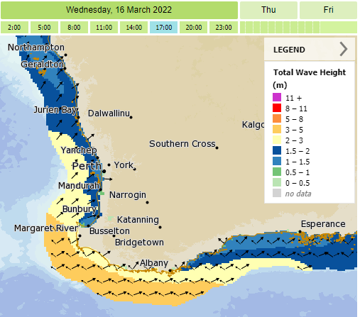 谢谢。Twitter 会使用此信息,来优化你的时间线。 撤销撤销
 -
#DryLightning has started more than 40 fires since Friday over southwest WA. It occurs when thunderstorms are particularly high above the ground and when the surface conditions are quite dry. Most rainfall from the storm evaporates before it reaches the ground.
@Astro_Grahamepic.twitter.com/fD1GAmJEs6 谢谢。Twitter 会使用此信息,来优化你的时间线。 撤销撤销
 -
 Severe
 #Thunderstorm Warning issued for parts of the Pilbara and Gascoyne. Damaging wind gusts possible. Locations which may be affected include Paraburdoo, Tom Price, Gascoyne Junction, Mount Augustus, Pannawonica and Three Rivers. Details at: http://ow.ly/XJLZ50IgKMs pic.twitter.com/Gvke4Ln4t0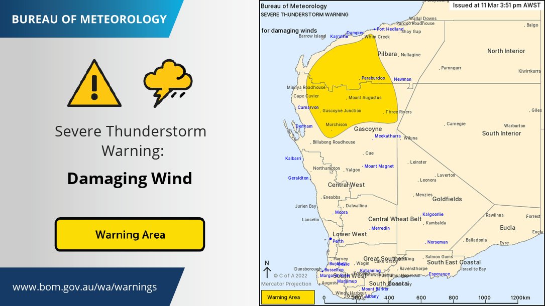 谢谢。Twitter 会使用此信息,来优化你的时间线。 撤销撤销
 -
SW to NW winds 10-15 kt expected for the start of the
#58CapeNaturaliste Race, SW'ly to SE'ly swell of 1-1.5 m, significant wave height (avg of highest 1/3 of waves) 1-1.5m. Winds and seas inshore will be lighter. For more details check#MetEye http://ow.ly/qIcp50IgGEy pic.twitter.com/NxNJkcikw1 谢谢。Twitter 会使用此信息,来优化你的时间线。 撤销撤销
 -
Scattered showers and isolated
#thunderstorms are rolling through the greater#Perth area as a west coast trough deepens. Trough moves inland, followed by a cooler change with daytime temperatures dropping about 10 degrees on Saturday. Radar updates at http://ow.ly/Uojs50IgH8a pic.twitter.com/XmDM222WJJ谢谢。Twitter 会使用此信息,来优化你的时间线。 撤销撤销 -
#Thunderstorms are expected in the#SWLD as a deepening west coast trough moves inland next few days. Risk of dry lightning. Some risk of damaging winds. Cooler change in the wake of the trough. Latest forecasts/warnings http://www.bom.gov.au/wa/ or the#BOMWeather apppic.twitter.com/v6cFUeaQyp谢谢。Twitter 会使用此信息,来优化你的时间线。 撤销撤销 -
Severe Thunderstorm Warning issued for the far northeast Kimberley. Damaging wind gusts are possible within the warning area. Details at: http://ow.ly/oca050Ibv6q pic.twitter.com/L1NTnczFq5
 谢谢。Twitter 会使用此信息,来优化你的时间线。 撤销撤销
 -
Don't miss the chance to join our
#climate experts as they look at the 2021-22 summer and the outlook for autumn 2022. Register now for tomorrow's Autumn 2022 Climate and Water Update#BOMWebinar: http://ow.ly/Qutp50Ibipl#webinar#weather#meteorology#waterpic.twitter.com/yAIh2W1wH0 谢谢。Twitter 会使用此信息,来优化你的时间线。 撤销撤销
 -
Your
#LabourDay public holiday forecast - thunderstorms in parts of the far north, cloudy in the south, sunny everywhere else! Check the forecast for where you are: http://ow.ly/NAIU50IbhWk pic.twitter.com/PCr1ZHiIal 谢谢。Twitter 会使用此信息,来优化你的时间线。 撤销撤销
 -
Severe
#thunderstorm warning issued for the eastern Kimberley for damaging winds. Locations which may be affected include Kununurra, Wyndham, Lake Argyle and Warmun. Warning updates at http://ow.ly/PsuF50I9RbK@dfes_wapic.twitter.com/TrOgHLlXZW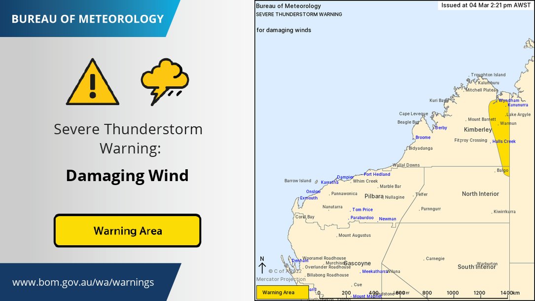 谢谢。Twitter 会使用此信息,来优化你的时间线。 撤销撤销
 -
@CycloneAnika crossed the coast near
#Nyangumarda country last night bringing rain and damaging winds to#Telfer and north#Nyamal. The system visits#Mardu country tonight before making its way into Central Desert land bringing 50-100mm. For the latest http://ow.ly/pfix50I8Nwh pic.twitter.com/RlyZ9QV6jW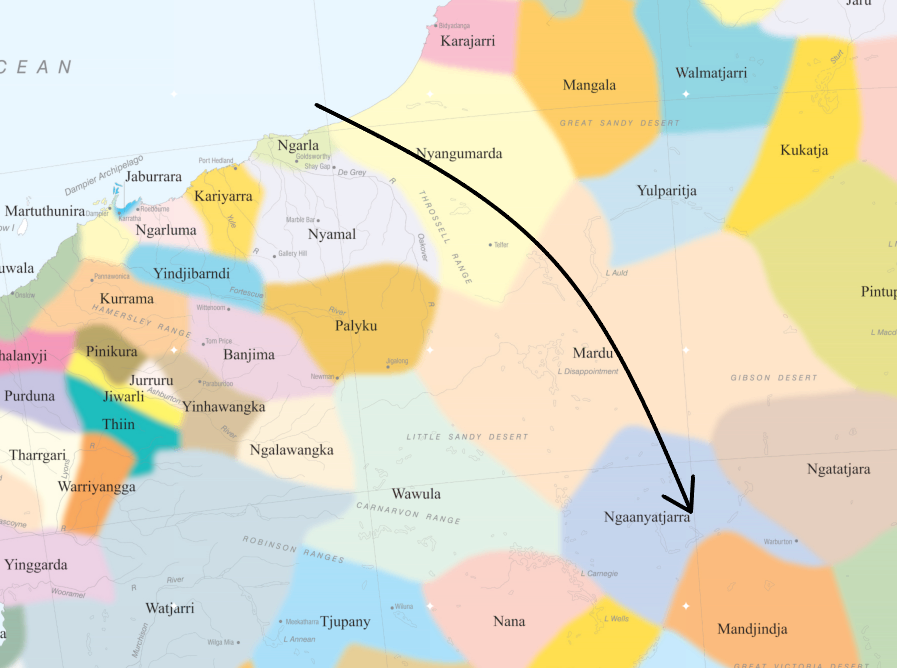 谢谢。Twitter 会使用此信息,来优化你的时间线。 撤销撤销
 -
#Perth has had its hottest summer on record &#WA saw its 7th warmest summer overall since records began in 1910. Read more on summer in#WA: http://www.bom.gov.au/climate/current/statement_archives.shtml?region=wa&period=season …pic.twitter.com/ht3l8Jws3w谢谢。Twitter 会使用此信息,来优化你的时间线。 撤销撤销 -
Tropical
#CycloneAnika crossed the WA coast at 80 Mile Beach near Wallal Downs at 8pm WST Wednesday night as a category 1 cyclone. Still impressive on satellite moving to southeast over the#Pilbara causing very heavy rain and damaging wind gusts. Warnings http://ow.ly/Rfjz50I8Fee pic.twitter.com/9BGhRLtq3E谢谢。Twitter 会使用此信息,来优化你的时间线。 撤销撤销 -
Brr!! If you thought it was chilly this morning, you were right -
#Perth dropped to 10.4°C at 6:30am Around the metro area,
 #SwanValley reached to 9.2°C while#PerthAirport dropped to 8.7°C. Down in the south west,#Narrogin shivered through their 3.7°C start this morning! pic.twitter.com/UVAxqldiEL
 谢谢。Twitter 会使用此信息,来优化你的时间线。 撤销撤销
 -
Tropical Cyclone Anika has re-developed as a category 1 tropical cyclone 3 days after weakening in the Kimberley. Expected to cross the coast in the vicinity of Wallal this evening.
#CycloneAnika http://www.bom.gov.au/cyclone pic.twitter.com/pP3kRwPxZw 谢谢。Twitter 会使用此信息,来优化你的时间线。 撤销撤销
 -
While
#CycloneAnika is only a Category 1 system, rain remains very significant! With 285mm recorded at Kilto, 130mm at Bidgydanga and Madora recording 100mm in four hours this system is very wet. Never drive through floodwaters, the latest visit - http://ow.ly/Z8tT50I7NeJ pic.twitter.com/haPhos98KM 谢谢。Twitter 会使用此信息,来优化你的时间线。 撤销撤销
 -
Ex-Tropical
#CycloneAnika tracked closer to the coast overnight meaning it now has very little chance to reintensify into a tropical cyclone before making landfall this evening. Gales are still possible along the coast, with 100-200mm of rain, and isolated falls up to 300mm.pic.twitter.com/zi4YBdXqCb 谢谢。Twitter 会使用此信息,来优化你的时间线。 撤销撤销
 -
Ex-Tropical Cyclone Anika is expected to redevelop into a tropical cyclone during Wednesday morning as it moves offshore. A coastal crossing on the far east Pilbara or west Kimberley coast is likely early on Thursday.
#CycloneAnika http://www.bom.gov.au/cyclone pic.twitter.com/VGlh8TQQxr 谢谢。Twitter 会使用此信息,来优化你的时间线。 撤销撤销
 -
Ex-Tropical Cyclone Anika is near the west Kimberley coast and is expected to redevelop tonight as it moves further offshore. A coastal crossing on the far east Pilbara or west Kimberley coast is likely early on Thursday.
#CycloneAnika http://www.bom.gov.au/cyclone pic.twitter.com/LeEJkfwa1R 谢谢。Twitter 会使用此信息,来优化你的时间线。 撤销撤销


加载似乎需要一段时间。
Twitter 可能超载或出现了暂时故障。重试或访问 Twitter 状态以了解更多信息。