Posts

Showing posts with the label Haggan

Siñot Dågu

Image
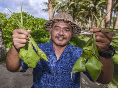
Hagas umatungo' ham yan este na taotao, si Siñot Joe "Dågu" Babauta, un ma'estron Chamorro yan gof maolek na titifok yan danderu. Desde i ma'pos na såkkan hu ayuyuda gui' mama'tinas lepblon e'eyak para i ma'estron Chamorro gi GDOE. Hu kekeayuda gui' på'go mama'nå'gue klas gi UOG para i otro semester (Fañomåkan 2018). Halacha nai hu interview gui' para i website Hongga Mo'na , ya debi di bei edit yan na'funhåyan ayu. Estague un tinige' put guiya yan i bidadå-ña ginen i gasetan PDN. **************************** "Chamorro teacher Joe 'Dågu' Babuata keeps weaving tradition alive" by Chloe Babauta Pacific Daily News August 7, 2017 When Joe “Dågu” Babauta saw “Tan Maria” weaving a hat out of coconut leaves at 12 years old, his lifelong love affair with the art of weaving began. “Being that I was so young, I had to ask older friends who drove to take me down there from Agat, to wh

The Pacific Remote Islands Marine Monument

Image
Mr. Obama’s Pacific Monument By THE EDITORIAL BOARD   OCT. 1, 2014 The New York Times   It’s safe to assume that most presidents have big ambitions and visions of lasting Rooseveltian achievement. Though, in recent history, the millstones of Washington’s pettiness and partisanship usually grind such dreams to dust. There are exceptions, which happen when presidents discover the Antiquities Act. This is the law, used by Theodore Roosevelt and many successors, by which the executive can permanently set aside public lands from exploitation, building an environmental legacy with a simple signature and without Congress’s consent. This is how President Obama last week, in addition to everything else on his plate, created the largest marine preserve in the world. He used his Antiquities Act authority to expand the Pacific Remote Islands Marine National

Looking at the Tip of the Spear

Image
Looking at the ‘tip of the spear’ How U.S. Military policy in Guam, a proposed “mega build-up” and population displacement are destroying the island and its people.  by Craig Santos Perez June 6, 2014 The Hawaii Independent Guåhan (Guam), an unincorporated territory of the United States, is the largest and most populated island in Micronesia. For a local comparison, Guåhan is larger than Lanaʻi yet smaller than Molokaʻi. Similar to Oʻahu, U.S.military bases occupy a third of Guåhan’s landmass. Kanaka Maoli activist and scholar Kaleikoa Kaʻeo once described the U.S. military as a monstrous heʻe (octopus). Imagine Pacific Command headquarters as its head, the mountaintop telescopes as its eyes, and the supercomputers and fiber optic networks as its brain and nerve system. Now imagine one of its weaponized tentacles strangling Guåhan: “The Tip of the Spear.” In 2009, details of a military “ mega-buildup ” on Guåhan were released in a dra

Support Nihi!!

Image
Below is my testimony in support of my cousin Cara's project Nihi. A locally made kids learning show, that I helped to write one of the pilot episodes for. The other day a hearing was held at the Guam Legislature to provide some funding to help get this project off the ground. As someone who helped make it possible, but also somehow who sees the potential for a project like this I was happy to come and show my support. You can read more of my thoughts below. I testified along with my daughter Sumahi, who was on my lap while I was speaking.  ****************************** Tinestigu ginnen Dr. Michael Lujan Bevacqua The Guam Legislature 6/12/13 Este i hagå-hu. I na’ån-ña Si Sumåhi. Desde mafañågu gui’ hu fino’ Chamoruruyi gui’ todu tiempo. Humuyonogña, siña gui’ fumino’ Chaomru. Esta kapas gui’ gi fino’ Chamoru. Kada diha kumuentos ham put mubi siha, cartoons, ga’ga’ gi lepblo yan maseha hafa otro gi lina’la’-mami. Lao achokka’ fifi

Pagat on Tumblr

Image
For the past week I've been pasting pictures of my many hikes to the Pagat area of northern Guam. In a one year period I hiked down there 14 times, and in the process exploring so many different areas there and finding lots of cool things. I don't have thousands of pictures of my trip, since more than once I lost a camera down there. But I do have enough to show different aspects of the Pagat area, most of which people don't really know. Pagat proper is the trail that takes you to the freshwater cave and then through a trail of lusong, past a single latte house, to get to the natural arch and the cliffs. Pagat is so much more than this, and I've been blessed to be able to explore and see so much more. On the Pagat loop trail you can see the limestone wall there which no one seems to be able to explain how it was made (but there are many fun theories). At Pagat point you can see two massive limestone rocks known as Chelef's Hands, named after a 17th century C