


Australian Weather
National Summary
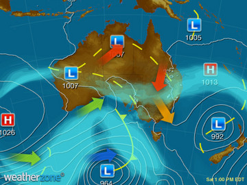
A low pressure trough over northern WA, the NT and western QLD is triggering showers and thunderstorms. A hot airmass is moving into QLD ahead of this system, leading to heatwave conditions. A low in the southeast is generating large surf. A front is crossing the southwest.
State Weather
Click for state forecasts


National Synoptic
Weather News
Enough rain to ruin the Santa Parade
13:32 EDT
After a busy weather week for Australia - with intense heat, storms, dust, snow and howling winds; it is now New Zealand's turn.
Temperatures set to soar for parts of QLD next week
12:58 EDT
Very hot air is making its way over northern and eastern parts of Queensland, with extreme heatwave conditions expected to impact a large area.


Extremes and Records
| Current Extremes | Last 3 Days Extremes | Extremes This Month | |||
|---|---|---|---|---|---|
| Thu 22/11 | Fri 23/11 | Sat 24/11 | |||
|
42.6°C Richmond, Qld |
Hottest |
41.6°C Wyndham Ap, WA |
41.7°C Wyndham Ap, WA |
42.1°C Rabbit Flat, NT |
45.7°C Roebourne Ap, WA |
|
3.0°C Thredbo Top Station, NSW/ACT |
Coldest |
-3.1°C Thredbo Top Station, NSW/ACT |
-2.1°C Oberon, NSW/ACT |
-0.9°C Thredbo Top Station, NSW/ACT |
-5.9°C Thredbo Top Station, NSW/ACT |
|
NNW 53km/h Hamilton Island Ap, Qld |
Windiest |
125km/h Wilsons Promontory, Vic |
107km/h Nowra Ran Air Station, NSW/ACT |
98km/h Halls Creek, WA |
- |
|
2.2mm last hr Rocky Gully, WA |
Wettest |
90.0mm Beamesbrook, Qld |
67.0mm Dum In Mirrie, NT |
67.0mm Piccaninny Plains Station, Qld |
52.2mm Halls Creek Ap, WA |
| Australia's Records for November | |||
|---|---|---|---|
| Max | Min | Rain | |
| Highest 48.7°C at Birdsville Police Station, Qld in 1990 Lowest -3.1°C at Thredbo Top Station, NSW/ACT in 1967 |
Highest 38.0°C at Balgo Hills, WA in 2015 Lowest -8.5°C at Thredbo Top Station, NSW/ACT in 1973 |
Highest 630.0mm at Bellenden Ker Top Stn, Qld in 1989 |
|
-
Display your Local Weather here
automatically each time you visit us:

Rotates through Temperature,
Wind, Humidity and RainUse the Search Bar above
to find your Local, and go to the Local page
Click "Set My Local"
button next to the location name


