

Australian Weather
National Summary
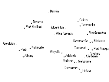
A trough is generating severe storms in the NT, western NSW, VIC, intense rain in TAS and showers and storms in western QLD. Cold fronts are bringing brisk winds and showers to southern WA and SA. High pressure is keeping the east coast mostly clear.
State Weather
Click for state forecasts


National Synoptic

Weather News
How do people living in the tropics stand the hot, humid climate?
16:08 EDT
It's a Saturday morning in mid-November at Darwin's Parap Markets.
How about a day of skiing and big wave surfing a week out from summer?
15:18 EDT
This weekend will offer the rare opportunity to go skiing in Australia's alps and surfing on large, clean waves along the NSW coast, on the same day, just one week out from summer.
Why wind shear matters for supercell thunderstorms
11:27 EDT
Severe thunderstorms are likely to affect a number of states and territories today and supercell thunderstorms are possible in parts of western NSW.


Extremes and Records
| Current Extremes | Last 3 Days Extremes | Extremes This Month | |||
|---|---|---|---|---|---|
| Sat 17/11 | Sun 18/11 | Mon 19/11 | |||
|
41.7°C Marble Bar, WA |
Hottest |
43.4°C Marble Bar, WA |
45.7°C Roebourne Ap, WA |
45.1°C Roebourne Ap, WA |
45.7°C Roebourne Ap, WA |
|
9.0°C Mt Buller, Vic |
Coldest |
-2.3°C Lake St Clair, Tas |
0.6°C Perisher Valley, NSW/ACT |
0.8°C Wandering, WA |
-5.9°C Thredbo Top Station, NSW/ACT |
|
N 53km/h Tasman Island, Tas |
Windiest |
105km/h Fitzroy Crossing Ap, WA |
103km/h Forrest, WA |
114km/h Tarcoola Ap, SA |
- |
|
3.4mm last hr Coldstream Comparison, Vic |
Wettest |
135.0mm Adelaide River, NT |
68.0mm Nardoo, Qld |
64.0mm Adelaide River, NT |
57.0mm Croker Island Ap, NT |
| Australia's Records for November | |||
|---|---|---|---|
| Max | Min | Rain | |
| Highest 48.7°C at Birdsville Police Station, Qld in 1990 Lowest -3.1°C at Thredbo Top Station, NSW/ACT in 1967 |
Highest 38.0°C at Balgo Hills, WA in 2015 Lowest -8.5°C at Thredbo Top Station, NSW/ACT in 1973 |
Highest 630.0mm at Bellenden Ker Top Stn, Qld in 1989 |
|
-
Display your Local Weather here
automatically each time you visit us:

Rotates through Temperature,
Wind, Humidity and RainUse the Search Bar above
to find your Local, and go to the Local page
Click "Set My Local"
button next to the location name


