


Australian Weather
National Summary
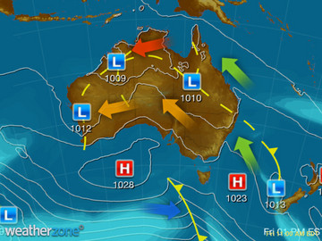
Troughs across the north and east are generating showers and thunderstorms, some intense. A trough over WA is also deepening, allowing heat to sink south. Onshore winds are bringing the odd shower to the QLD coast. A high is keeping the central south mostly clear.
State Weather
Click for state forecasts


National Synoptic
Weather News
BOM forecast wet start to summer for NSW, but not drought-breaking
20:18 EDT
There is some good news for New South Wales farmers struggling with drought — the Bureau of Meteorology (BOM) is predicting a wet start to summer.
Perth's summer set to be a hot one according to the Bureau of Meteorology summer forecast
19:52 EDT
A spring scorcher on Friday of 36 degrees Celsius is shaping up as a taste of things to come, with a hot summer heading our way — in stark contrast to the unusually cool summer of 2017-18.
Australia's summer outlook
15:29 EDT
A dry and hot summer is anticipated for much, but not all of Australia, according to the latest seasonal outlook issued by the Bureau of Meteorology on Thursday.


Extremes and Records
| Current Extremes | Last 3 Days Extremes | Extremes This Month | |||
|---|---|---|---|---|---|
| Mon 12/11 | Tue 13/11 | Wed 14/11 | |||
|
38.2°C Marble Bar, WA |
Hottest |
43.0°C Brunette Downs, NT |
43.4°C Fitzroy Crossing Ap, WA |
45.2°C Fitzroy Crossing Ap, WA |
45.2°C Fitzroy Crossing Ap, WA |
|
-0.5°C Mt Wellington, Tas |
Coldest |
4.7°C Guyra, NSW/ACT |
2.0°C Lake Leake, Tas |
-0.4°C Mt Wellington, Tas |
-5.9°C Thredbo Top Station, NSW/ACT |
|
SSE 46km/h Wattamolla, NSW/ACT |
Windiest |
81km/h Mt Wellington, Tas |
88km/h Maatsuyker Is, Tas |
116km/h Lake Julius, Qld |
- |
|
7.6mm last hr Douglas River, NT |
Wettest |
34.8mm Oenpelli Airport, NT |
553.6mm Longerenong, Vic |
105.0mm Berrimah, NT |
73.2mm Darwin Ap, NT |
| Australia's Records for November | |||
|---|---|---|---|
| Max | Min | Rain | |
| Highest 48.7°C at Birdsville Police Station, Qld in 1990 Lowest -3.1°C at Thredbo Top Station, NSW/ACT in 1967 |
Highest 38.0°C at Balgo Hills, WA in 2015 Lowest -8.5°C at Thredbo Top Station, NSW/ACT in 1973 |
Highest 630.0mm at Bellenden Ker Top Stn, Qld in 1989 |
|
-
Display your Local Weather here
automatically each time you visit us:

Rotates through Temperature,
Wind, Humidity and RainUse the Search Bar above
to find your Local, and go to the Local page
Click "Set My Local"
button next to the location name


