


Australian Weather
National Summary
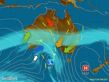
A frontal system is bringing patchy rain, storms and a blustery colder change to TAS, VIC and NSW with showers in northeast NSW and QLD are easing as onshore winds weaken ahead of the system. Warm and gusty northerlies are affecting the eastern interior.
State Weather
Click for state forecasts


National Synoptic
Weather News
A glimmer of spring warmth for Sydney
17:17 EST
After a cool end to August and a not so warm start to September for Sydney, things look to heat up a touch heading into the middle of the month.
Fire chiefs around country warn Australia of bleak bushfire outlook
15:24 EST
As fire chiefs from around the country stood ready to announce the Southern Australian Bushfire Outlook for 2018/2019, there was a grim sense of inevitability.
Why these people are helping drought-affected farmers
15:00 EST
What motivates us to open our hearts and wallets? It's an especially timely question, as the widespread drought in the eastern states worsens with every rainless day, and when the Bureau of Meteorology forecasts relief may be months away.


Extremes and Records
| Current Extremes | Last 3 Days Extremes | Extremes This Month | |||
|---|---|---|---|---|---|
| Mon 03/09 | Tue 04/09 | Wed 05/09 | |||
|
37.2°C Argyle Ap, WA |
Hottest |
39.1°C Bradshaw-Angallari, NT |
40.2°C Fitzroy Crossing Ap, WA |
38.8°C Wyndham Ap, WA |
40.2°C Fitzroy Crossing Ap, WA |
|
1.3°C Mt Hotham, Vic |
Coldest |
-6.6°C Perisher Valley, NSW/ACT |
-5.5°C Thredbo Top Station, NSW/ACT |
-2.2°C Norseman Ap, WA |
-8.8°C Thredbo Top Station, NSW/ACT |
|
N 61km/h Mt Wellington, Tas |
Windiest |
88km/h Cape Moreton, Qld |
100km/h Cape Leeuwin, WA |
111km/h Mt Read, Tas |
- |
|
1.6mm last hr Coldstream Comparison, Vic |
Wettest |
83.0mm Byfield, Qld |
100.0mm Ballina Ap, NSW/ACT |
71.2mm Tindarra, Qld |
32.0mm Ballina Ap, NSW/ACT |
| Australia's Records for September | |||
|---|---|---|---|
| Max | Min | Rain | |
| Highest 43.1°C at West Roebuck, WA in 2003 Lowest -6.2°C at Mt Buller, Vic in 1995 |
Highest 30.0°C at Warmun, WA in 2016 Lowest -16.7°C at Charlotte Pass, NSW/ACT in 1970 |
Highest 370.3mm at Burdekin, Qld in 1890 |
|
-
Display your Local Weather here
automatically each time you visit us:

Rotates through Temperature,
Wind, Humidity and RainUse the Search Bar above
to find your Local, and go to the Local page
Click "Set My Local"
button next to the location name


