

Australian Weather
National Summary
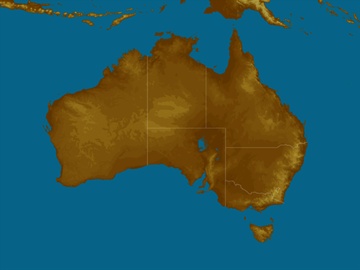
Troughs in the east are generating showers and storms in southern QLD and northern and eastern NSW, heaviest on the coast. A high is clearing VIC, TAS and SA. A front is bringing a few showers to southwest WA. Warm, dry winds in the north.
State Weather
Click for state forecasts


National Synoptic

Weather News
Rainy start to spring in parts of NSW and Qld
15:58 EST
Parts of the coast, ranges and slopes of New South Wales and Queensland have gained some decent rain in the past few days and most places have a chance of more in the next few.
NSW, Qld emerging from lengthy late season chill
14:36 EST
Southeastern Australia is finally warming up and parts of New South Wales and Queensland emerge from their coldest spell this late in the year in decades.
NSW records its driest year since 1965 but the Top End gets 'abnormal' winter rain
10:54 EST
This winter was Australia's fifth-warmest winter on record when looking at daytime temperatures, according to the Bureau of Meteorology's Rainfall was below average, particularly in New South Wales, where it was the eighth-driest winter on record and the driest since 2002.


Extremes and Records
| Current Extremes | Last 3 Days Extremes | Extremes This Month | |||
|---|---|---|---|---|---|
| Sat 01/09 | Sun 02/09 | Mon 03/09 | |||
|
39.3°C Fitzroy Crossing Ap, WA |
Hottest |
37.2°C Wyndham Ap, WA |
39.0°C Bradshaw, NT |
39.1°C Bradshaw-Angallari, NT |
39.6°C Fitzroy Crossing Ap, WA |
|
0.0°C Mt Hotham, Vic |
Coldest |
-8.8°C Thredbo Top Station, NSW/ACT |
-8.6°C Thredbo Top Station, NSW/ACT |
-6.6°C Perisher Valley, NSW/ACT |
-8.8°C Thredbo Top Station, NSW/ACT |
|
WNW 59km/h Cape Leeuwin, WA |
Windiest |
116km/h Wilsons Promontory, Vic |
66km/h Tasman Island, Tas |
88km/h Cape Moreton, Qld |
- |
|
6.0mm last hr Ballina Ap, NSW/ACT |
Wettest |
21.8mm Pt Perpendicular, NSW/ACT |
28.0mm Nashua, NSW/ACT |
83.0mm Byfield, Qld |
79.0mm Ballina Ap, NSW/ACT |
| Australia's Records for September | |||
|---|---|---|---|
| Max | Min | Rain | |
| Highest 43.1°C at West Roebuck, WA in 2003 Lowest -6.2°C at Mt Buller, Vic in 1995 |
Highest 30.0°C at Warmun, WA in 2016 Lowest -16.7°C at Charlotte Pass, NSW/ACT in 1970 |
Highest 370.3mm at Burdekin, Qld in 1890 |
|
-
Display your Local Weather here
automatically each time you visit us:

Rotates through Temperature,
Wind, Humidity and RainUse the Search Bar above
to find your Local, and go to the Local page
Click "Set My Local"
button next to the location name


