
Community Seismic Network
Community Seismic Network facilitates the block-by-block collection of ground motion intensity data before, during, and after earthquakes, using inexpensive accelerometers.
How do the Sensors Work?
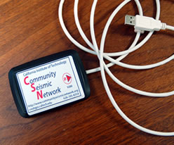 In targeted communities, CSN distributes seismic sensors to volunteers free of charge. Volunteers connect the sensor to their own computer, download an application from the CSN website, and are immediately part of the data collection network.
CSN data is used during an earthquake to provide very high resolution data on actual ground shaking in realtime to first responders. Longer term, it enables scientific construction of 3D geologic models of the ground underneath the sensors, which will influence land use policy and construction codes.
Where is the network?
 Our initial targeted area is the greater Pasadena region of Southern California, which is loosely bounded by highways CA-2 on the west, I-10 on the south, and I-605 on the east, and the San Gabriel mountain range along the north. Within this general area, we will provide volunteers with no-cost seismometers. Volunteer locations include homes, schools, churches, offices, businesses and other settings.


