


Visualising Victoria’s Groundwater
Visualising Victoria’s Groundwater (VVG) provides online access to information about groundwater for the State of Victoria. VVG consolidates data from over 400,000 bores from four authoritative sources, together with Victorian aquifer information, hydrogeological models, historical records and maps. VVG includes 2D and 3D visualisations of Victoria’s aquifers and provides information on relevant geological features, the depth of groundwater resources and groundwater quality. VVG received the 2013 Victorian iAward, Regional category and was a merit recipient at the 2013 National iAwards.
 |
Background
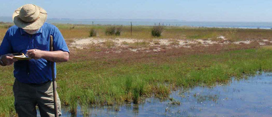
Groundwater is a precious resource that is often misunderstood and has been the subject of myth. Until recently Victorian groundwater data was inaccessible to the community. A CeRDI-led initiative, VVG has enabled online access to comprehensive groundwater data for the first time.
VVG is the first of its kind in Australia to offer real-time visualisation of a resource normally invisible to the public. Previously, information about Victoria’s groundwater data was difficult to locate and was stored in various databases, with only a fraction of the information available online.
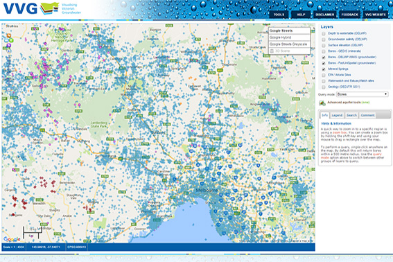 |
VVG provides a central site for accessing Victoria’s ground water information. VVG is spatially enabled and consolidates data from over 400,000 bores from four authoritative sources together with Victorian aquifer information with features that include 2D and 3D visualisations, hydrogeological models and historical records and maps.
VVG has received wide acclaim from the technology and science industries culminating in several awards including recipient 2013 Victorian iAwards (Regional category), merit recipient 2013 National iAwards (Regional category), finalist in the 2013 Asia Pacific ICT Alliance (APICTAs; Sustainability and Environmental Technology category), and finalist in the 2013 Australian and New Zealand Internet Awards (ANZIAs; Innovation category).
Outcomes
This ease of access and exploration of Victoria’s groundwater data means that VVG can now be readily adopted by water users, resource managers, landowners and conservation groups to inform their decisions about managing consumptive water use and environmental water flows.
CeRDI impact research has identified that:
- A strength of VVG is that it is an interoperable resource with a single point of access allowing users to readily explore groundwater issues or the questions over time;
- VVG has led to productivity and efficiency gains through decreased time in data sourcing and processing, and in responding to inquiries;
- Users saw benefits in consolidating, combining and comparing data from multiple sources to identify data duplication, data gaps and/or data inaccuracies and emerging issues;
- The VVG portal had increased user capacity to manage the knowledge themselves; and
- The VVG portal is seen as a de facto information provider:
- Since establishment, the VVG has become a central resource in terms of knowledge management and the provision of trusted advice on groundwater issues;
- Ease of access and an open access policy plays an important role in building end user confidence in seeking information relevant to their needs;
- VVG, through the provision of support, advice, and web services is addressing a service need not currently addressed in more traditional areas of groundwater information provision.
The provision of multiple datasets from disparate sources within a single portal has changed practices in the Victorian groundwater industry.
Innovation
CeRDI was a participant in the interoperability experiment as part of the development of the Groundwater Mark-up Language version 2 (GroundWaterML2) initiated by the Open Geospatial Consortium (OGC). As a testbed for the official OGC interoperability experiment, CeRDI worked closely with other participants to ensure the standard was implementation-ready.
The web-based 3D Visualisation component of the VVG portal was developed in collaboration with the Groundwater Visualisation team at QUT. The system was able to deliver the 3D rendering power of the GVS desktop system via a web browser for the first time. Newly available browser technology (HTML5 web-sockets) was used to allow the user to interact with the remote 3D server which was able to stream the 3D scene in real-time. Read more
 |
Technical Features
Spatial data infrastructure (SDI) has been developed and deployed to federate groundwater data from disparate database sources into a single web portal thereby making data more easily discoverable.
In collaboration with the project partners and stakeholders, the VVG portal was designed to include the following features:
- user requests will be fulfilled via real-time access to remote databases by integrating the interoperable web services they each provide;
- the data resides with the data managers (ensuring currency and validity);
- it has a spatial map function that is intuitive to use (similar to Google Maps);
- all forms of data are included – vector, raster, text and multimedia;
- data downloads are allowed (subject to data custodian's consent);
- spatial data entities link to the original source documents and images;
- it is capable of dynamically synthesising the data;
- interactive 3D visualisations can be created for user-selected scenes;
- users can add, edit or update data (subject to quality assurance and quality control);
- the spatial data and models are credible to the user.
Approach
Initiated by CeRDI, this unique project has drawn significant interest from local, state, national and international organisations with fifteen research institutions, government bodies and businesses collaborating on the project. These partnerships have enabled the project to be supported and to achieve outcomes well beyond the project’s original scope.
Initial funding was obtained from the Victorian Government Broadband Enabled Innovation Program.
Data are maintained across the different databases by various authorities and organisations. CeRDI has employed its expertise in interoperable technologies and high speed broadband to capture, aggregate and spatially depict Victoria's groundwater systems into one comprehensive and publically accessible web portal.
Future Directions
Now that the GroundwaterML 2 standard has been approved by the OGC, the VVG portal will be re-engineered to consume and provide all relevant data using the standard. The mapping interface will be overhauled in 2017 and new features introduced including responsive design to cater for more devices and users. Improved usability, new visualisations and search/filtering options will be a focus of new developments. We will also be looking as ways to improve the quality of the data using automated means. This will underpin a new focus on research discoveries within the data and tools to assist with this.
The Visualising Victoria’s Groundwater (VVG) portal is setting new standards in user access and functionality. Justifiably, it has won numerous industry best practice awards. Its rapidly growing use is a result of its ability to federate a diverse range of data, its ease of accessibility and the quality of the data. The frequency of use and repeat visitation rates testify to its value and it is a tribute to the CeRDI team’s efforts.
MR BRUCE SIMONS, CSIRO.
-

RESEARCH OUTPUT
Dahlhaus, P.G., Murphy, A., MacLeod, A., Thompson, H., McKenna, K., Ollerenshaw, A. Making the invisible visible: the impact of federating groundwater data in Victoria, Australia J. Hydroinformatics (March 2016) 18 (2) 238-255; DOI: 10.2166/hydro.2015.169
-

AWARDS
VVG has received wide acclaim from the technology and science industries culminating in several awards including;
-

PARTNERS
Victorian Government Department of Economic Development, Jobs, Transport and Resources
Contribution of geological bore database and seamless geology, expertise and advice, test site for data transfers.

Australian National University (Integrated Catchment Assessment and Management Centre)
Co-funder, domain expertise and knowledge, development of research tools, end-use testing.
Southern Rural Water
Contribution of 3D models of the groundwater systems of southern Victoria, data provision, governance, service user.
Victorian Department of State Development, Business and Innovation
Co-funder through BEIP investment.
Victorian eResearch Strategic Initiative (VeRSI)
Expertise and knowledge of research hardware and software infrastructure, technical advice, and development or research tools.

CSIRO
National Geoscience Information Infrastructure - Minerals Down Under FlagshipExpertise and knowledge, especially in the Spatial Information Services Stack and OGC standards.

Goulburn Murray Water
Contribution of knowledge of the groundwater systems of northern Victoria, data provision, governance, service user.

Queensland University of Technology
3D groundwater system modelling and visualisation experts, domain and data expertise.

Natural Resources Canada (NRCan)
Geological Survey of CanadaExpert knowledge of existing eResearch tools, OGC standards, and contributor to developments.
Senversa Pty Ltd
Trial consumers of end-use data and models, advisors on potential uses.

Cooperative Research Centre for Spatial Information (CRCSI)
Contribute expertise and knowledge.