.png)


Interoperable Spatial Knowledge Base for Integrated Fire Management Planning*
The Barwon South West Interoperable Spatial Knowledge Base is a web-based portal which supports regional, local and community level planning to manage assets from the risk and consequences of fire and other emergency events. This collaborative project spatially maps existing data plus open source data overlayed on asset landscapes, in order to better understand risk and consequences associated with these events. The Knowledge Base is a tool to assist with prevention, preparedness, response and recovery.
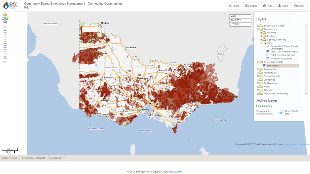 |
| Interoperable Spatial Knowledge Base for Integrated Fire Management Planning map |
Background
Fire and emergency management planning committees, government departments, utility providers, water authorities, businesses and the broader community require timely access to relevant, current spatial information and linked documents for better informed decision making and integrated plan development.
The Barwon South West Interoperable Spatial Knowledge Base is an interoperable spatial information system designed to provide the most current relevant information, including fire risk data, in a manner that supports the community to develop their integrated regional and local fire management plans.
 |
This collaborative and stakeholder-led project commenced in 2012. It utilised existing data plus open data overlayed on asset landscapes, in order to better understand fire risk and consequences across the prevention, preparedness, response and recovery spectrum.
The funding for the development of this Knowledge Base has been provided by the Victorian Government. In addition, significant in-kind contributions have been made from a range of stakeholder and partner organisations.
The main objective is to allow all stakeholders easy access to the most current data to improve fire risk management decision making.
Outcomes
The web-enabled Knowledge Base has improved access to federated (aggregated) information by multiple stakeholders and has resulted in significant productivity improvements, in particular in enabling visualisation and reporting without the need for time consuming manual processes.
Fire incident data may now be readily generated on demand, without the need for the re-generation of grid maps for each different stakeholder request. In addition, the use of dynamic spatial mapping and visualisation tools enhance the ability to obtain insights from the data.
The project has received state-wide interest, which has led to invitations for CeRDI to present at various industry forums including Newtech Colac, 2013, and the Municipal Association of Victoria, Local Government Information and Communications Technology Group, March Forum, 2013.
This project highlights CeRDI’s innovations and capabilities to use ICT and web based systems to improve and enhance traditional knowledge and communications approaches.
Innovation
A range of new Open Source systems was sourced to underpin the required functionality. These were integrated with CeRDI’s existing GIS platform to develop a new product with significantly enhanced functionality and which allowed key project stakeholders to take ownership of the Knowledge Base.
Additionally, several innovative spatial functions were developed during this project. This included the ability for users to visualise fire incident data in new ways without compromising private or confidential location information. Specifically, fire incident data in gridded form; whereby each 1km square is coloured based on the number of incidents occurring within that grid cell. The IFMP team were generating these types of static maps in a desktop GIS environment to meet the specific needs of various local governments and planning committees. Each request to change the timeframe or incident category to be incorporated required a new map to be generated.
CeRDI was able to take this static map generation process and by web-enabling it, authenticated users of the portal are able to customise this information by date and incident category, dynamically regenerating the grid as required. The user is also able to draw a custom area on the map and generate a report of incidents by type and rolling year counts for that area. Again this replaced existing manual processes for generating these reports.
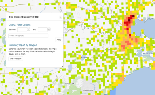 |
| Interoperable Spatial Knowledge Base for Integrated Fire Management Planning map |
Technical Features
The Knowledge Base utilises new technologies and innovative research to explore and expand datasets plus build features such as printable maps, community crowd sourcing capabilities and secure member login. It utilises CeRDI-developed single source publishing technology that provides the capability to develop, implement and continually improve integrated regional and municipal fire and emergency management plans.
The major focus of the Knowledge Base project is interoperability: The use of open standards and interoperable technologies enables the federation of data stored in different database schemas on disparate systems, empowering data managers and the broader community to share their data in the same virtual space whilst maintaining custodianship and ownership of the data.
Our vision was to create a robust and stable open source web platform that is intuitive to use and provides current and timely information via the internet. The Knowledgebase platform provides comprehensive information regarding assets at risk from fire, with the capability to develop, improve and expand to support an ‘all hazards, all agencies approach’ across multiple risk environments in the future
MR STEVE CAMERON, COMMUNITY BASED EMERGENCY MANAGEMENT, EMERGENCY MANAGEMENT VICTORIA
*Integrated Fire Management Planning (IFMP) is now Emergency Management Victoria (EMV)
-

PARTNERS
Emergency Management Victoria
Emergency Management Victoria funded the Project.
Barwon South West Regional Strategic Fire Management Planning Committee
Barwon South West Regional Strategic Fire Management Planning Committee was the Project Sponsor.
Victorian State Fire Management Planning Committee
Victorian State Fire Management Planning Committee provided Project oversight and direction.
Country Fire Authority
Country Fire Authority was a key stakeholder and supplied data.

Department of Environment, Land, Water and Planning
Department of Environment, Land, Water and Planning (DELWP) was a key stakeholder and supplied data.