Mapping and Understanding Bushfire and Natural Hazard Vulnerability
CeRDI, in collaboration with the Victoria Institute of Strategic Economic Studies at Victoria University is building spatial maps of economic, social and environmental values at risk in Victoria from bushfire and natural hazards. This research is being undertaken for the Bushfire and Natural Hazards CRC.
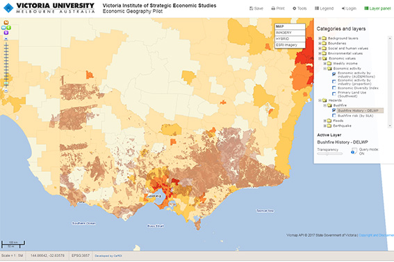 |
| Victoria Institute of Strategic Economic Studies - Economic Geography Pilot |
Background
Currently, Australia has a large imbalance between disaster relief and recovery payments, and investments in resilience and risk mitigation. At the same time, increasing climate-related hazards and exposure to those hazards will result in greater damage and loss. Existing institutional arrangements would see future insured losses increase, along with uncompensated losses and demands on government compensation. Uncompensated losses have a disproportionate effect on small businesses, communities and the natural environment. Many of these, we identify as un-owned risks, and many such risks are systemic, not being well identified at the institutional scale.
Recent events show not only do the immediate and direct economic impacts of bushfires and natural hazards need to be better understood, but also the medium and long-term direct and indirect costs to the economy (tangibles) and associated damages to non-monetary values (intangibles).
Certain climate-related natural hazards (e.g., heat extremes) and their indicators (e.g., fire danger indices) are increasing faster than projected. Even if this rate of increase tapers off, the current risk burden is unsustainable. It is becoming increasingly apparent that new institutional arrangements are needed to fully prepare for and respond to these changing risks. This requires a more complete understanding of which values are at risk, and of current and potential institutional vulnerability and risk ownership. This understanding can be used to allocate risk ownership across multiple institutions through a process-based framework.
The project objective is to develop a framework for understanding the ownership of risks from bushfires and natural hazards at the institutional level in order to improve risk governance through a range of measures, including investment strategies, resilience and risk mitigation.
Outcomes
The Victoria Institute of Strategic Economic Studies (VISES) at Victoria University was and is undertaking research for the Bushfire and Natural Hazards Cooperative Research Centre (CRC). CeRDI partnered in this research to build an economic geography from spatial data linked to a range of economic, social and environmental values and natural hazards data, creating maps of values at risk. The initial focus of the project was bushfire and natural hazard vulnerability in Victoria, but as the project evolves, it is expected that this will be expanded nationally.
The VISES Economic Geography Pilot was progressively developed and now features over 40 spatial data layers from 17 different data sources. Where possible, data layers have been integrated directly from the data custodians using interoperable standards. Data layers can be compared and interrogated using the standard mapping tools. Various methods of displaying demographic and other social data were tested at different geographic scales. The platform was a central tool utilised in workshops run by the VISES team to understand decision-making at the institutional scale.
Innovation
Through the Economic Geography project, CeRDI has become aware of, and been able to access, the wealth of demographic and socio-economic data that is publicly available and able to be represented spatially. While there are many data-explorers and mapping websites available for these datasets, rarely do they allow the user to access ‘other’ data outside the direct responsibility of that agency or custodian.
Clearly understanding the various use-cases was critical to the successful implementation of this demonstrator, particularly the ability to visually represent risk from natural hazards against other environmental and economic factors.
Approach
The key purpose of the partnership was to draw upon the skills and knowledge of CeRDI to develop a tailored solution for the ‘values at risk’ map. This would enable the VISES team to identify where opportunities exist for the application of new technologies in the development of the project. This may be in the form of web based mapping, online portals, knowledge management and Geographical Information Systems (GIS). GIS can inform ‘big picture’ understanding and enhance decision making processes, create greater efficiencies in communication, increase the quality of information and support policy formulation and evaluation
Initially a ‘broad brush-stroke’ Victoria-wide picture of vulnerability and values at risk to bushfire and natural hazards at the institutional scale was developed. A comprehensive selection of social and economic measures was then combined with hazard data to ascertain hot spots of institutional vulnerability where multiple values are at risk. These measures were mapped at the Local Government Area (LGA) scale to communicate current and potential future risks and where key areas of vulnerability lie.
This map formed the basis for developing, in collaboration with key stakeholders, a process-based framework that enabled decision-makers to work through the task of risk allocation in these areas. Following testing with key stakeholders and end users, the draft map of values at risk developed in the first stage was updated to reflect additional values at risk or institutional vulnerabilities that emerged during the workshop process.
The aim was to build a picture of the factors needed to enable institutional resilience to changing bushfires and natural hazards. Resilience was explored through institutional frameworks and processes to manage risks from unique and unpredictable (though not unforeseeable) combinations of natural hazards. Ultimately a proof of concept framework was developed that supported institutional resilience and was suitable for implementation.
-

RESEARCH OUTPUT
Symons, J. Jones, R.N. Milne, R. and MacLeod, A. (2015) Economic Geography of Bushfire and Flood Vulnerability in Victoria at the Statistical Local Area Scale, Climate Change Working Paper No. 26. Victoria Institute of Strategic Economic Studies, Victoria University, Melbourne.