- published: 28 Jan 2012
- views: 2300
-
remove the playlistTropical_cyclone_scales
-
remove the playlistTropical_cyclone
-
remove the playlistLatest Videos
-
remove the playlistLongest Videos
- remove the playlistTropical_cyclone_scales
- remove the playlistTropical_cyclone
- remove the playlistLatest Videos
- remove the playlistLongest Videos
- published: 01 Sep 2016
- views: 126
- published: 25 Feb 2016
- views: 65
- published: 23 Oct 2015
- views: 2085
- published: 04 Feb 2011
- views: 3773
- published: 23 Oct 2015
- views: 15050
- published: 02 Feb 2011
- views: 3316
- published: 02 Feb 2012
- views: 1200
Tropical cyclone scales
Tropical cyclones are officially ranked on one of five tropical cyclone scales, according to their maximum sustained winds and which tropical cyclone basin(s) they are located in. Only a few scales of classifications are used officially by the meteorological agencies monitoring the tropical cyclones, but some alternative scales also exist, such as accumulated cyclone energy, the Power Dissipation Index, the Integrated Kinetic Energy Index, and the Hurricane Severity Index.
Should a tropical cyclone form in the North Atlantic Ocean or the North-eastern Pacific Ocean, it will be classified using one of the categories in the Saffir-Simpson Hurricane Scale. In the Western Pacific, tropical cyclones will be ranked using the Japan Meteorological Agency's scale. The Regional Specialized Meteorological Centre (RSMC) in New Delhi, India also uses a different scale to assess the maximum sustained winds of a tropical cyclone. In the Southern Hemisphere, the Météo-France forecast center on La Reunion uses a scale that covers the whole of the South West Indian Ocean. Both the Australian Bureau of Meteorology and the RSMC in Nadi, Fiji use the Australian tropical cyclone intensity scale.
This article is licensed under the Creative Commons Attribution-ShareAlike 3.0 Unported License, which means that you can copy and modify it as long as the entire work (including additions) remains under this license.

Tropical cyclone
A tropical cyclone is a rapidly rotating storm system characterized by a low-pressure center, strong winds, and a spiral arrangement of thunderstorms that produce heavy rain. Depending on its location and strength, a tropical cyclone is referred to by names such as hurricane (/ˈhʌrᵻkən/ or /ˈhʌrᵻkeɪn/), typhoon /taɪˈfuːn/, tropical storm, cyclonic storm, tropical depression, and simply cyclone.
Tropical cyclones typically form over large bodies of relatively warm water. They derive their energy through the evaporation of water from the ocean surface, which ultimately recondenses into clouds and rain when moist air rises and cools to saturation. This energy source differs from that of mid-latitude cyclonic storms, such as nor'easters and European windstorms, which are fueled primarily by horizontal temperature contrasts. The strong rotating winds of a tropical cyclone are a result of the conservation of angular momentum imparted by the Earth's rotation as air flows inwards toward the axis of rotation. As a result, they rarely form within 5° of the equator. Tropical cyclones are typically between 100 and 2,000 km (62 and 1,243 mi) in diameter.
This article is licensed under the Creative Commons Attribution-ShareAlike 3.0 Unported License, which means that you can copy and modify it as long as the entire work (including additions) remains under this license.
- Loading...

-
 1:32
1:32Tropical Cyclone Funso (2012), Animation
Tropical Cyclone Funso (2012), AnimationTropical Cyclone Funso (2012), Animation
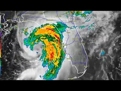
Animation of the intense cyclone that caused widespread flooding in Mozambique in January 2012. This storm was a Category 4 hurricane on the Saffir Simpson Hurricane Scale with estimated wind speeds just shy of 140mph. Damage is believed to be major, with at least 26 deaths as of January 28. -
 0:45
0:45Tropical Storm Hermine to Category 1 Hurricane
Tropical Storm Hermine to Category 1 HurricaneTropical Storm Hermine to Category 1 Hurricane
Tropical Storm Hermine to Category 1 Hurricane. Data from an Air Force Reserve Hurricane Hunter aircraft indicate that maximum sustained winds in Hermine have increased to near 75 mph -
 0:50
0:50Tropical Cyclone Winston Hourly.
Tropical Cyclone Winston Hourly.Tropical Cyclone Winston Hourly.
"Severe Tropical Cyclone Winston was the strongest tropical cyclone to make landfall over Fiji on record. The system was first noted as a tropical disturbance on 7 February 2016, when it was located to the northwest of Port Vila, Vanuatu. Over the next few days, the system gradually developed as it moved southeast, acquiring gale-force winds by 11 February. The following day, it underwent rapid intensification and attained ten-minute maximum sustained winds of 175 km/h (110 mph). Less favourable environmental conditions prompted weakening thereafter. After turning northeast on 14 February, Winston stalled to the north of Tonga on 17 February. Regaining strength and due to a change in higher level steering the storm drifted back to the west, achieving Category 5 status on both the Australian tropical cyclone scale and the Saffir–Simpson hurricane wind scale on 19 February. It reached its peak intensity the next day with ten-minute sustained winds of 230 km/h (145 mph) and a pressure of 915 hPa (mbar; 27.03 inHg), shortly before making landfall on Viti Levu, Fiji." Information Source: https://en.wikipedia.org/wiki/Cyclone_Winston Satellite Images from Himawari 8 IR1 source: http://weather.is.kochi-u.ac.jp/index-e.html Animation was constructed using 430 hourly images from Himawari 8 - From 7th of Feb to 24th of Feb 2016. -
 6:33
6:33Large-Scale Interactions of Tropical Cyclones
Large-Scale Interactions of Tropical CyclonesLarge-Scale Interactions of Tropical Cyclones
-
 0:34
0:34Hurricane Wind Damage: Saffir-Simpson Scale
Hurricane Wind Damage: Saffir-Simpson ScaleHurricane Wind Damage: Saffir-Simpson Scale
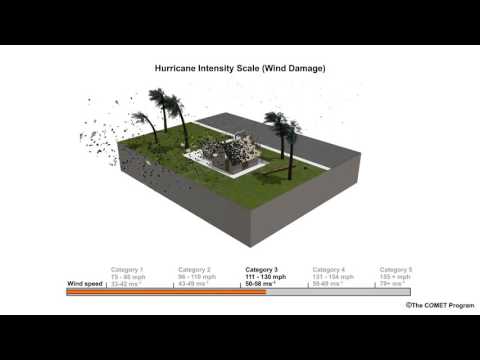
Animation showing an example of hurricane wind damage as measured using the Saffir-Simpson Scale. To learn more about hurricane winds and tropical cyclones, see the MetEd lesson, Introduction to Tropical Meteorology, 2nd Edition Chapter 8: Tropical Cyclones (https://www.meted.ucar.edu/training_module.php?id=868) -
 5:50
5:50GALE FORCE WIND WARNINGS/Tornado Watch
GALE FORCE WIND WARNINGS/Tornado Watch -
 2:34
2:34Tropical Cyclone Yasi (a category 5 cyclone).wmv
Tropical Cyclone Yasi (a category 5 cyclone).wmvTropical Cyclone Yasi (a category 5 cyclone).wmv
The devastation of Yasi. It is a tribute to the people, State Emergency Services, Queensland Disaster Management Services and volunteers that the immediate reported human statistics of this latest disaster were kept to 0 fatalities and 0 serious injuries and just 1 missing person. Damage to property and livelihood, however, remains uncountable. The pain and cost to Queensland and Queenslanders continues. The Premier's Disaster Relief Fund set up after the floods is to be extended to cover damage caused by Tropical Cyclone Yasi. Donate link: http://www.qld.gov.au/floods/donate.html -
 1:11
1:11wow Hurricane Patricia hit (Mexico) Strongest ever recorded category 5 cyclone
wow Hurricane Patricia hit (Mexico) Strongest ever recorded category 5 cyclonewow Hurricane Patricia hit (Mexico) Strongest ever recorded category 5 cyclone
Breaking News video Strongest ever recorded category 5 patricia mexico... -
 3:32
3:32CNN: Category 5 cyclone slams into Australia
CNN: Category 5 cyclone slams into AustraliaCNN: Category 5 cyclone slams into Australia
A devastating category 5 cyclone hits an already flooded Australia forcing thousands of evacuations. -
 1:18
1:18Tropical Cyclone Iggy (2012), Animation
Tropical Cyclone Iggy (2012), AnimationTropical Cyclone Iggy (2012), Animation
Animation of the moderate storm that caused little to no effect to western Australia in late January/early February 2012. This storm reached approximately 72mph wind speed, putting it as a borderline Tropical Storm/Category 1 on the Saffir Simpson Hurricane Scale.
-

Tropical Cyclone Funso (2012), Animation
Animation of the intense cyclone that caused widespread flooding in Mozambique in January 2012. This storm was a Category 4 hurricane on the Saffir Simpson Hurricane Scale with estimated wind speeds just shy of 140mph. Damage is believed to be major, with at least 26 deaths as of January 28.
published: 28 Jan 2012 -

Tropical Storm Hermine to Category 1 Hurricane
Tropical Storm Hermine to Category 1 Hurricane. Data from an Air Force Reserve Hurricane Hunter aircraft indicate that maximum sustained winds in Hermine have increased to near 75 mph
published: 01 Sep 2016 -

Tropical Cyclone Winston Hourly.
"Severe Tropical Cyclone Winston was the strongest tropical cyclone to make landfall over Fiji on record. The system was first noted as a tropical disturbance on 7 February 2016, when it was located to the northwest of Port Vila, Vanuatu. Over the next few days, the system gradually developed as it moved southeast, acquiring gale-force winds by 11 February. The following day, it underwent rapid intensification and attained ten-minute maximum sustained winds of 175 km/h (110 mph). Less favourable environmental conditions prompted weakening thereafter. After turning northeast on 14 February, Winston stalled to the north of Tonga on 17 February. Regaining strength and due to a change in higher level steering the storm drifted back to the west, achieving Category 5 status on both the Australia...
published: 25 Feb 2016 -

Large-Scale Interactions of Tropical Cyclones
published: 27 Jan 2011 -

Hurricane Wind Damage: Saffir-Simpson Scale
Animation showing an example of hurricane wind damage as measured using the Saffir-Simpson Scale. To learn more about hurricane winds and tropical cyclones, see the MetEd lesson, Introduction to Tropical Meteorology, 2nd Edition Chapter 8: Tropical Cyclones (https://www.meted.ucar.edu/training_module.php?id=868)
published: 23 Oct 2015 -

-

Tropical Cyclone Yasi (a category 5 cyclone).wmv
The devastation of Yasi. It is a tribute to the people, State Emergency Services, Queensland Disaster Management Services and volunteers that the immediate reported human statistics of this latest disaster were kept to 0 fatalities and 0 serious injuries and just 1 missing person. Damage to property and livelihood, however, remains uncountable. The pain and cost to Queensland and Queenslanders continues. The Premier's Disaster Relief Fund set up after the floods is to be extended to cover damage caused by Tropical Cyclone Yasi. Donate link: http://www.qld.gov.au/floods/donate.html
published: 04 Feb 2011 -

wow Hurricane Patricia hit (Mexico) Strongest ever recorded category 5 cyclone
Breaking News video Strongest ever recorded category 5 patricia mexico...
published: 23 Oct 2015 -

CNN: Category 5 cyclone slams into Australia
A devastating category 5 cyclone hits an already flooded Australia forcing thousands of evacuations.
published: 02 Feb 2011 -

Tropical Cyclone Iggy (2012), Animation
Animation of the moderate storm that caused little to no effect to western Australia in late January/early February 2012. This storm reached approximately 72mph wind speed, putting it as a borderline Tropical Storm/Category 1 on the Saffir Simpson Hurricane Scale.
published: 02 Feb 2012
Tropical Cyclone Funso (2012), Animation
- Order: Reorder
- Duration: 1:32
- Updated: 28 Jan 2012
- views: 2300
- published: 28 Jan 2012
- views: 2300
Tropical Storm Hermine to Category 1 Hurricane
- Order: Reorder
- Duration: 0:45
- Updated: 01 Sep 2016
- views: 126
- published: 01 Sep 2016
- views: 126
Tropical Cyclone Winston Hourly.
- Order: Reorder
- Duration: 0:50
- Updated: 25 Feb 2016
- views: 65
- published: 25 Feb 2016
- views: 65
Large-Scale Interactions of Tropical Cyclones
- Order: Reorder
- Duration: 6:33
- Updated: 27 Jan 2011
- views: 76
- published: 27 Jan 2011
- views: 76
Hurricane Wind Damage: Saffir-Simpson Scale
- Order: Reorder
- Duration: 0:34
- Updated: 23 Oct 2015
- views: 2085
- published: 23 Oct 2015
- views: 2085
GALE FORCE WIND WARNINGS/Tornado Watch
- Order: Reorder
- Duration: 5:50
- Updated: 13 Sep 2016
- views: 1917
Tropical Cyclone Yasi (a category 5 cyclone).wmv
- Order: Reorder
- Duration: 2:34
- Updated: 04 Feb 2011
- views: 3773
- published: 04 Feb 2011
- views: 3773
wow Hurricane Patricia hit (Mexico) Strongest ever recorded category 5 cyclone
- Order: Reorder
- Duration: 1:11
- Updated: 23 Oct 2015
- views: 15050
- published: 23 Oct 2015
- views: 15050
CNN: Category 5 cyclone slams into Australia
- Order: Reorder
- Duration: 3:32
- Updated: 02 Feb 2011
- views: 3316
- published: 02 Feb 2011
- views: 3316
Tropical Cyclone Iggy (2012), Animation
- Order: Reorder
- Duration: 1:18
- Updated: 02 Feb 2012
- views: 1200
- published: 02 Feb 2012
- views: 1200
-

What are hurricanes, typhoons and tropical cyclones?
What are hurricanes, typhoons and tropical cyclones and how do they form? James Chubb explains how we classify the different storms and how they are formed.
published: 14 Nov 2011 -

-

Center Parcs Elveden Tropical Cyclone 2014
Today I show you a video of the NEW ride at Elveden Center Parcs filmed on a GoPro Hero3 Remember to Subscribe, Like and Comment Gaming Channel - http://www.youtube.com/user/MentalMonkeys1000 Sister -http://www.youtube.com/channel/UCMMbsKIww7MXXpMKcfOx7qA http://www.youtube.com/user/ZoeVlogs111 Twitter - https://twitter.com/MentalMonkeys Facebook - https://www.facebook.com/pages/Mentalmonkeys/118381751695703 Instagram - http://instagram.com/joetography57 Editing Software - http://www.cyberlink.com/products/powerdirector-ultra/features_en_US.html Music - http://www.youtube.com/user/FreeSongsToUse Go Pro - http://gopro.com/cameras/hd-hero3-white-edition
published: 28 Feb 2014 -

Understanding tropical cyclone categories
Improve your understanding of tropical cyclone categories and their impacts. This video explains what the different tropical cyclones categories are, the hazards involved and the potential damage a tropical cyclone can cause. See http://www.bom.gov.au/cyclone for all current tropical cyclone warnings for the Australian region.
published: 19 Nov 2015 -

Severe Tropical Cyclone Marcia Chase Yeppoon
Oz Cyclone chasers are on the ground to get footage and data from Category 5 Severe Tropical Cyclone Marcia WARNING COARSE LANGUAGE This action was streamed live to our subscribers so to become one please head to www.ozcyclonechasers.com.au/subscribe
published: 23 Feb 2015 -

Tropical Cyclone at Center Parcs Elveden Forest
The world-first Tropical Cyclone sees two award-winning water rides joined together for the very first time. Guests staying at Elveden Forest can experience a series of exciting twists, turns and drops in a four-person clover-shaped raft reaching speeds of up to 30mph. To book a break at Center Parcs Elveden Forest visit http://bit.ly/1piDJJ2
published: 19 Jun 2014 -

Hermine becomes post-tropical cyclone, moves into Atlantic
WAVY-TV 10 Team Coverage of Hermine.
published: 03 Sep 2016 -

Tropical Cyclone POV Center Parcs HD
[ENGLISH] CHANGE THE VIDEO QUALITY by clicking on the gear icon (if you are having problems with buffering, lower it). [ESPAÑOL] PUEDE CAMBIAR LA CALIDAD DEL VÍDEO. Si tiene problemas al reproducir un vídeo, haga clic en el icono de rueda dentada que aparece en la parte derecha del reproductor de vídeo y seleccione la calidad que prefiera. [FRANÇAIS] ON PEUT MODIFIER LA QUALITÉ DE CETTE VIDÉO. Si vous rencontrez un problème lors de la lecture d'une vidéo, cliquez sur l'icône représentant une roue dentée sous le côté droit du lecteur vidéo, puis sélectionnez la qualité qui vous convient.
published: 25 Jan 2013 -

How cyclones form
published: 07 Apr 2013 -

What are hurricanes, typhoons and tropical cyclones?
- Order: Reorder
- Duration: 6:27
- Updated: 14 Nov 2011
- views: 283287
- published: 14 Nov 2011
- views: 283287
CNN Explains: Tropical cyclones
- Order: Reorder
- Duration: 2:28
- Updated: 26 May 2012
- views: 198777
Center Parcs Elveden Tropical Cyclone 2014
- Order: Reorder
- Duration: 2:26
- Updated: 28 Feb 2014
- views: 239842
- published: 28 Feb 2014
- views: 239842
Understanding tropical cyclone categories
- Order: Reorder
- Duration: 3:07
- Updated: 19 Nov 2015
- views: 9192
- published: 19 Nov 2015
- views: 9192
Severe Tropical Cyclone Marcia Chase Yeppoon
- Order: Reorder
- Duration: 7:41
- Updated: 23 Feb 2015
- views: 37479
- published: 23 Feb 2015
- views: 37479
Tropical Cyclone at Center Parcs Elveden Forest
- Order: Reorder
- Duration: 1:29
- Updated: 19 Jun 2014
- views: 139027
- published: 19 Jun 2014
- views: 139027
Hermine becomes post-tropical cyclone, moves into Atlantic
- Order: Reorder
- Duration: 11:42
- Updated: 03 Sep 2016
- views: 1396
Tropical Cyclone POV Center Parcs HD
- Order: Reorder
- Duration: 1:44
- Updated: 25 Jan 2013
- views: 157160
- published: 25 Jan 2013
- views: 157160
How cyclones form
- Order: Reorder
- Duration: 1:23
- Updated: 07 Apr 2013
- views: 111218
- published: 07 Apr 2013
- views: 111218
Tropical Cyclogenesis- Tropical Cyclone Formation
- Order: Reorder
- Duration: 3:00
- Updated: 03 Jul 2010
- views: 71157
-

-

-

Severe Tropical Storm Conson / 08W (2016)
Severe Tropical Storm Conson, 08W, of the 2016 West Pacific Typhoon Season. http://www.ssd.noaa.gov/
published: 05 Sep 2016 -

-

-

Tropical Storm Fiona, Two Tropical Waves & Sunday Severe Weather
Download my app http://www.meteorologistjoecioffi.com/index.php/app/ Tropical Storm Fiona continues to hang on while 2 other tropical waves are showing signs they could develop. Weather model analysis regarding any threat to the US plus a look at Sunday's severe weather threat.
published: 21 Aug 2016 -

Severe Tropical Storm Chanthu Slams Japan
published: 17 Aug 2016 -

Tropical Depression May Form In The Atlantic Severe Weather Threat
Download my weather app http://www.meteorologistjoecioffi.com/index.php/app/ Tropical Depression could form in the Eastern Atlantic. Severe weather threat this afternoon & evening in the northern Mid Atlantic Northeast.
published: 16 Aug 2016 -

Tropical Weather Severe Weather Threat Heat & Humidity
Download weather app http://www.meteorologistjoecioffi.com/index.php/app/ The latest GFS model on the tropics over the next 2 weeks. Severe weather possible today Southeast New England. Hot and very humid weather continues in the New York New Jersey Connecticut area with the risk for thunderstorms.
published: 12 Aug 2016 -

Severe Tropical Storm Omais / 07W (2016)
Severe Tropical Storm Omais, 07W, of the 2016 West Pacific Typhoon Season. http://www.ssd.noaa.gov/
published: 11 Aug 2016
Severe Tropical Storm Conson (JMA: 1606, JTWC: 08W)
- Order: Reorder
- Duration: 0:38
- Updated: 05 Sep 2016
- views: 8
Severe Tropical Storm Omais (JMA: 1605, JTWC: 07W)
- Order: Reorder
- Duration: 0:40
- Updated: 05 Sep 2016
- views: 11
Severe Tropical Storm Conson / 08W (2016)
- Order: Reorder
- Duration: 1:32
- Updated: 05 Sep 2016
- views: 10
- published: 05 Sep 2016
- views: 10
Severe Tropical Storm Mirinae (JMA: 1603, JTWC: 05W)
- Order: Reorder
- Duration: 0:16
- Updated: 03 Sep 2016
- views: 9
Severe Tropical Storm Nida (JMA: 1604, JTWC: 06W, PAGASA: Carina)
- Order: Reorder
- Duration: 0:28
- Updated: 03 Sep 2016
- views: 9
Tropical Storm Fiona, Two Tropical Waves & Sunday Severe Weather
- Order: Reorder
- Duration: 6:05
- Updated: 21 Aug 2016
- views: 1129
- published: 21 Aug 2016
- views: 1129
Severe Tropical Storm Chanthu Slams Japan
- Order: Reorder
- Duration: 5:53
- Updated: 17 Aug 2016
- views: 244
- published: 17 Aug 2016
- views: 244
Tropical Depression May Form In The Atlantic Severe Weather Threat
- Order: Reorder
- Duration: 4:24
- Updated: 16 Aug 2016
- views: 101
- published: 16 Aug 2016
- views: 101
Tropical Weather Severe Weather Threat Heat & Humidity
- Order: Reorder
- Duration: 3:58
- Updated: 12 Aug 2016
- views: 349
- published: 12 Aug 2016
- views: 349
Severe Tropical Storm Omais / 07W (2016)
- Order: Reorder
- Duration: 1:27
- Updated: 11 Aug 2016
- views: 62
- published: 11 Aug 2016
- views: 62
-

Documentary - Severe Tropical Cyclone Marcia Chase
Tropical Cyclone Marcia at Yeppoon 180-200kmh winds trees down houses destroyed WARNING some language
published: 01 Mar 2015 -

Tropical Cyclone Marcia, Rockhampton 2015. Into The Eye
Footage of severe tropical cyclone Marcia as it impacted Rockhampton. The eye passed right over Rocky as a strong category 3 storm with powerful winds and heavy rain leading to flash flooding in Moores Creek. We were at the Rocky Shopping Center in Berserker during the height of the storm. This footage gives you an idea of what it is like being in a cyclone. Hearts go out to the people affected by this event. Footage is Copyright
published: 25 Feb 2015 -

Super Typhoon Haiyan Documentary - Monster Typhoon -The world's most deadliest Storm !!!!
Super Hurricane Haiyan Documentary - Monster Hurricane -The world's most deadliest Storm !!! Typhoon Haiyan, known in the Philippines as Typhoon Yolanda, was one of the strongest tropical cyclones ever recorded, devastating portions of Southeast Asia, particularly the Philippines, in early-November 2013.[1] It is the deadliest Philippine typhoon recorded in modern history,[2] killing at least 6,300 people in that country alone.[3] Haiyan is also the strongest storm recorded at landfall, and the strongest typhoon ever recorded in terms of one-minute sustained wind speed.[4][5] As of January 2014, bodies were still being found.[6] The thirtieth named storm of the 2013 Pacific typhoon season, Haiyan originated from an area of low pressure several hundred kilometers east-southeast of Pohnpei ...
published: 23 Oct 2015 -

Dangerman - The Perfect Storm
Subscribe to Naked Science - http://goo.gl/wpc2Q1 Every other Wednesday we present a new video, so join us to see the truth laid bare... Dangerman - Adventures of Geoff Mackley Follow adventurer and cameraman extraordinaire Geoff Mackley as he travels through the world's most dangerous hotspots to bring viewers never-before-seen footage of incredible storms, volcanoes, tornadoes, hurricanes, and much more besides. The Perfect Storm Extreme cameraman Geoff Mackley risks life and limb flying to Taiwan, South Korea and the USA, attempting to film inside powerful typhoons and hurricanes. The term Typhoon is the regional name in the northwest Pacific for a severe tropical cyclone, whereas hurricane is the regional term in the northeast Pacific and northern Atlantic. Elsewhere this is cal...
published: 01 Apr 2015 -

Aussie Cyclone Update April 7th 2014
Oz Cyclone Chasers are now in PRE-PLANNING MODE TC Ita is expected to move west and intensify into a Severe Tropical Cyclone before making landfall on the Peninsula or North Tropical Coast. Today's timeline is as follows: Please remember you do not have to watch the whole thing, just the bits that interest you. 0:00 - 3:50 - What we expect to happen and the track maps 3:50 - 7:35 - TC Ita on satellite and microwave imagery now 7:35 - 17:50 - Where the models have Ita crossing, and the longer term potential for a recurve - PLEASE NOTE Models do not accurately forecast intensities so take intensity estimates with a grain of salt - we expect intensities to be stronger than modelled. 17:50 - 24:15 - Discussion about the Upper Level steering patterns in play 24:15 - 25:35 - brief discussion a...
published: 07 Apr 2014 -

LIVE Discussion on TC Ashobaa, 94E, US Severe Wx - Jun 9, 2015
Talking tropics and severe weather Tropical Cyclone Ashobaa approaching Oman as a significant tropical storm. Invest 94E which may form in the next few days in the Eastern Pacific. US Severe weather that may occur during the show, and reviewing yesterday's activity and Hurricane Blanca. Also answering your questions and comments throughout.
published: 09 Jun 2015 -

LIVE Discussion on Tropical Storm Carlos, Severe Weather (06/12/15)
Latest information and discussion on Tropical Storm Carlos and US Severe weather, and as always we will entertain your questions and comments, too.
published: 12 Jun 2015 -

StormGeo's 2015 Severe Weather and Tropical Outlook Webinar
StormGeo's hurricane expert, Chris Hebert provides his seasonal update of the current severe weather season as well as a detailed look ahead to the Atlantic Hurricane Season. With host, StormGeo Meteorologist Dave Gorham.
published: 24 Apr 2015 -

TWNS/RWS Live Severe Weather/Tropical Storm Coverage 5/9/15-5/10/15
Live Severe Weather/Tropical Storm Coverage
published: 10 May 2015 -

TYPHOON "FERDIE" (MERANTI) Closer to Batanes | TYPHOON MERANTI AFTERMATH Update 2016
PAGASA, Batanes Update: SEVERE WEATHER BULLETIN #11 TROPICAL CYCLONE WARNING: TYPHOON "FERDIE" (MERANTI) Issued at 5:00 p.m., 13 September 2016 Typhoon "FERDIE" has slightly accelerated while traversing the Bashi Channel and moving closer to Batanes group of islands. -Estimated rainfall amount is from moderate to heavy within the 600 km diameter of the typhoon. -The typhoon is expected to be in the vicinity of Batanes this midnight or tomorrow early morning. -Residents in Northern Luzon are advised to take precautionary measures against impacts of very strong winds and heavy rainfall. Location of Eye/Center: (as of 4:00 p.m.) 165 km East of Basco, Batanes Coordinates: 20.2°N, 123.5°E Strength: Maximum sustained winds of up to 215 kph near the center and gustiness of up to 250 kph. ...
published: 13 Sep 2016
Documentary - Severe Tropical Cyclone Marcia Chase
- Order: Reorder
- Duration: 35:53
- Updated: 01 Mar 2015
- views: 6832
- published: 01 Mar 2015
- views: 6832
Tropical Cyclone Marcia, Rockhampton 2015. Into The Eye
- Order: Reorder
- Duration: 43:42
- Updated: 25 Feb 2015
- views: 39946
- published: 25 Feb 2015
- views: 39946
Super Typhoon Haiyan Documentary - Monster Typhoon -The world's most deadliest Storm !!!!
- Order: Reorder
- Duration: 50:33
- Updated: 23 Oct 2015
- views: 12225
- published: 23 Oct 2015
- views: 12225
Dangerman - The Perfect Storm
- Order: Reorder
- Duration: 47:52
- Updated: 01 Apr 2015
- views: 81396
- published: 01 Apr 2015
- views: 81396
Aussie Cyclone Update April 7th 2014
- Order: Reorder
- Duration: 25:38
- Updated: 07 Apr 2014
- views: 10170
- published: 07 Apr 2014
- views: 10170
LIVE Discussion on TC Ashobaa, 94E, US Severe Wx - Jun 9, 2015
- Order: Reorder
- Duration: 62:26
- Updated: 09 Jun 2015
- views: 1287
- published: 09 Jun 2015
- views: 1287
LIVE Discussion on Tropical Storm Carlos, Severe Weather (06/12/15)
- Order: Reorder
- Duration: 58:11
- Updated: 12 Jun 2015
- views: 139
- published: 12 Jun 2015
- views: 139
StormGeo's 2015 Severe Weather and Tropical Outlook Webinar
- Order: Reorder
- Duration: 25:29
- Updated: 24 Apr 2015
- views: 559
- published: 24 Apr 2015
- views: 559
TWNS/RWS Live Severe Weather/Tropical Storm Coverage 5/9/15-5/10/15
- Order: Reorder
- Duration: 145:46
- Updated: 10 May 2015
- views: 56
TYPHOON "FERDIE" (MERANTI) Closer to Batanes | TYPHOON MERANTI AFTERMATH Update 2016
- Order: Reorder
- Duration: 23:35
- Updated: 13 Sep 2016
- views: 161
- published: 13 Sep 2016
- views: 161
- Playlist
- Chat
- Playlist
- Chat

Tropical Cyclone Funso (2012), Animation
- Report rights infringement
- published: 28 Jan 2012
- views: 2300

Tropical Storm Hermine to Category 1 Hurricane
- Report rights infringement
- published: 01 Sep 2016
- views: 126

Tropical Cyclone Winston Hourly.
- Report rights infringement
- published: 25 Feb 2016
- views: 65

Large-Scale Interactions of Tropical Cyclones
- Report rights infringement
- published: 27 Jan 2011
- views: 76

Hurricane Wind Damage: Saffir-Simpson Scale
- Report rights infringement
- published: 23 Oct 2015
- views: 2085

GALE FORCE WIND WARNINGS/Tornado Watch
- Report rights infringement
- published: 13 Sep 2016
- views: 1917

Tropical Cyclone Yasi (a category 5 cyclone).wmv
- Report rights infringement
- published: 04 Feb 2011
- views: 3773

wow Hurricane Patricia hit (Mexico) Strongest ever recorded category 5 cyclone
- Report rights infringement
- published: 23 Oct 2015
- views: 15050

CNN: Category 5 cyclone slams into Australia
- Report rights infringement
- published: 02 Feb 2011
- views: 3316

Tropical Cyclone Iggy (2012), Animation
- Report rights infringement
- published: 02 Feb 2012
- views: 1200
- Playlist
- Chat

What are hurricanes, typhoons and tropical cyclones?
- Report rights infringement
- published: 14 Nov 2011
- views: 283287

CNN Explains: Tropical cyclones
- Report rights infringement
- published: 26 May 2012
- views: 198777

Center Parcs Elveden Tropical Cyclone 2014
- Report rights infringement
- published: 28 Feb 2014
- views: 239842

Understanding tropical cyclone categories
- Report rights infringement
- published: 19 Nov 2015
- views: 9192

Severe Tropical Cyclone Marcia Chase Yeppoon
- Report rights infringement
- published: 23 Feb 2015
- views: 37479

Tropical Cyclone at Center Parcs Elveden Forest
- Report rights infringement
- published: 19 Jun 2014
- views: 139027

Hermine becomes post-tropical cyclone, moves into Atlantic
- Report rights infringement
- published: 03 Sep 2016
- views: 1396

Tropical Cyclone POV Center Parcs HD
- Report rights infringement
- published: 25 Jan 2013
- views: 157160

How cyclones form
- Report rights infringement
- published: 07 Apr 2013
- views: 111218

Tropical Cyclogenesis- Tropical Cyclone Formation
- Report rights infringement
- published: 03 Jul 2010
- views: 71157
- Playlist
- Chat

Severe Tropical Storm Conson (JMA: 1606, JTWC: 08W)
- Report rights infringement
- published: 05 Sep 2016
- views: 8

Severe Tropical Storm Omais (JMA: 1605, JTWC: 07W)
- Report rights infringement
- published: 05 Sep 2016
- views: 11

Severe Tropical Storm Conson / 08W (2016)
- Report rights infringement
- published: 05 Sep 2016
- views: 10

Severe Tropical Storm Mirinae (JMA: 1603, JTWC: 05W)
- Report rights infringement
- published: 03 Sep 2016
- views: 9

Severe Tropical Storm Nida (JMA: 1604, JTWC: 06W, PAGASA: Carina)
- Report rights infringement
- published: 03 Sep 2016
- views: 9

Tropical Storm Fiona, Two Tropical Waves & Sunday Severe Weather
- Report rights infringement
- published: 21 Aug 2016
- views: 1129

Severe Tropical Storm Chanthu Slams Japan
- Report rights infringement
- published: 17 Aug 2016
- views: 244

Tropical Depression May Form In The Atlantic Severe Weather Threat
- Report rights infringement
- published: 16 Aug 2016
- views: 101

Tropical Weather Severe Weather Threat Heat & Humidity
- Report rights infringement
- published: 12 Aug 2016
- views: 349

Severe Tropical Storm Omais / 07W (2016)
- Report rights infringement
- published: 11 Aug 2016
- views: 62
- Playlist
- Chat

Documentary - Severe Tropical Cyclone Marcia Chase
- Report rights infringement
- published: 01 Mar 2015
- views: 6832

Tropical Cyclone Marcia, Rockhampton 2015. Into The Eye
- Report rights infringement
- published: 25 Feb 2015
- views: 39946

Super Typhoon Haiyan Documentary - Monster Typhoon -The world's most deadliest Storm !!!!
- Report rights infringement
- published: 23 Oct 2015
- views: 12225

Dangerman - The Perfect Storm
- Report rights infringement
- published: 01 Apr 2015
- views: 81396

Aussie Cyclone Update April 7th 2014
- Report rights infringement
- published: 07 Apr 2014
- views: 10170

LIVE Discussion on TC Ashobaa, 94E, US Severe Wx - Jun 9, 2015
- Report rights infringement
- published: 09 Jun 2015
- views: 1287

LIVE Discussion on Tropical Storm Carlos, Severe Weather (06/12/15)
- Report rights infringement
- published: 12 Jun 2015
- views: 139

StormGeo's 2015 Severe Weather and Tropical Outlook Webinar
- Report rights infringement
- published: 24 Apr 2015
- views: 559

TWNS/RWS Live Severe Weather/Tropical Storm Coverage 5/9/15-5/10/15
- Report rights infringement
- published: 10 May 2015
- views: 56

TYPHOON "FERDIE" (MERANTI) Closer to Batanes | TYPHOON MERANTI AFTERMATH Update 2016
- Report rights infringement
- published: 13 Sep 2016
- views: 161
[VIDEO]: Alien Fleet Passes Through Our Solar System And Ignores Us
Edit WorldNews.com 21 Sep 2016Nasa to hold announcement about potentially life-supporting ocean on Jupiter’s moon, Europa
Edit The Independent 21 Sep 2016FBI's NY Bombing Focus Shifts To Two Men Who Took Suitcase Containing Bomb
Edit WorldNews.com 21 Sep 2016Brad Pitt, Angelina Jolie Divorce: ‘Very Saddened’ Actor Breaks Silence Over Split
Edit Huffington Post 21 Sep 2016Ryan says House will vote to override any veto of 9/11 bill
Edit Politico 21 Sep 2016Tropical Depression Karl and Tropical Storm Lisa (Meteorological Service of Jamaica)
Edit Public Technologies 22 Sep 2016BMI Congratulates its 2016 Latin GRAMMY Nominees (BMI - Broadcast Music lnc)
Edit Public Technologies 22 Sep 2016Pittsburgh-region art exhibitions sure to have something to please every eye this fall
Edit Pittsburgh Tribune Review 22 Sep 2016'That time when' a phrase meaning little took over
Edit Tampa Bay Times 22 Sep 2016Heavy rain in 48 hours: IMD
Edit The Hindu 22 Sep 2016Everglades warrior, environmentalist Joe Browder dies at 78
Edit The Miami Herald 22 Sep 2016Live WaterSmart by Turning off Irrigation Systems after Rainstorm (San Diego County Water Authority)
Edit Public Technologies 22 Sep 2016CQIRP comes to life with new Ag and Environment laboratories (Central Queensland University)
Edit Public Technologies 22 Sep 2016Nearly half of Singaporeans would change jobs for more holidays (Fiji Airways Ltd)
Edit Public Technologies 22 Sep 2016Nightmare on city roads
Edit The Hindu 22 Sep 2016Violent protests over fatal US police shooting
Edit Arabnews 22 Sep 2016- 1
- 2
- 3
- 4
- 5
- Next page »


