I’ve taken up running, spurred on by my marathon-grade brother-in-law who leaves mysterious comb-shaped GPS trails across Leeds, visible in a training app he recommended. Tethered by elaborate descriptions of exertion, our phones have become tracking devices for sweaty meanders mapped onto distant terrains. I show the app to my colleague, who remarks that my own canal-side routes in Berlin seem a little cramped in comparison. I need to loosen-up; find my own signature, open myself to suggestion from the cosmos.
In Athens again, and a friend here has recommended me another app, made by a different sports-wear manufacturer. “It wasn’t a tip,” she protests over coffee. “I’m telling you I want you to use it!” The interface is friendlier: turquoise and egg-yolk yellow, with clearer maps and a chummy typeface. But the audio stats, which hail each passing kilometre, are growled by a canned voice called Kat. You can choose Drill Instructor too, but Kat’s probably fine for now.
Half-way up Lycabettus.
My first Athens run is on Mount Lycabettus: a literary homage, of sorts, and close to the apartment. In Don DeLillo’s 1982 novel The Names, the banker David Keller is shot at whilst running here. There is conspiracy in the undergrowth. I’m not seeking thrills, as such, though after three kilometres I begin to suspect the hill is made entirely of ascents. There is a chapel at the summit, with divine antenna, fucking with the topography.
More than once I’m told that the National Gardens are a better spot. “I’m off to Smog Park”, I tell my wife one Sunday, and head down into the Athens basin. All Athenian runners seem to have converged here, some bearing numbers on their chests, though an organised race is hard to discern amongst the vegetation and twisting gravel paths. I plunge into the humid space, and beat a random trail. With parakeets screeching overhead, I scan the undergrowth for tortoises.
Divination or free will? GPS trail in the National Gardens of Athens
It wouldn’t be completely facetious to wonder whether the health benefits of running here aren’t offset by Athens’ smog problem. A tripling in cost of heating oil since the crisis began has left many unable to afford their bills, and wood-burning (furniture-burning, trash-burning) is not uncommon. Forest fires don’t help. Scientists are alarmed by airborne levels of lead, arsenic and cadmium.
The benevolent cloud is in possession of a clear edge. There is delight in a puffy cloud. But the edgeless cloud is infused with dread. We give a different name to fog, as the view from inside the cloud obscures the tangible. Fog, and its evil anthropogenic twin, smog (or – worse – the preternatural-terror of ozone, oxygen turned putrid, and one atom too heavy), envelopes and enshrouds, penetrates even. It is our proximity to the cloud which colours our judgement. The deceit of cloud computing is its contradiction of this narrative: it purports to be everywhere, and well-intentioned, but is demonstrably local, and subject to nefarious machinations.
Ionized gas particles in a Phywe PJ45 diffusion cloud chamber, revealing proton interactions and cosmic ray spallation [source: YouTube]
I save my run-data to the cloud, and review the stats from a sun-lit bench. My pace merits scrutiny. A jagged graph shows temporal changes in elevation, but my route gives me pause: I have drawn a cloud, of sorts, in the fabric of the park. The swirls and loops of my trail are fully characteristic of the National Gardens, which function as a giant cloud chamber, a supersaturated vaporous medium in which my erratic course divines the interactions of protons, cosmic ray spallation or the trajectory of positrons at an urban scale. At a spooky quantum level, notions of free will become conjectural. A passing high-energy muon collides with a subatomic particle in my toe, leading me to prefer one path to another. Or perhaps it was the feral dogs, leering by the fountain, or the shirtless alpha-male alpha-particle who brushes my shoulder on a tight, bright corner.
Joe was in town, and we went walking. Joe is my doppelgänger of sorts, which suggests the duplicate, but also motion. It might be better to describe him as my stunt-double, living a life approximate to how my own might have played-out had I stayed in the UK. Joe comes from the Black Forest, and was completing his MA in communication design in the UK, just as I was completing my BA in the same discipline. He settled in London. I emigrated to Berlin.
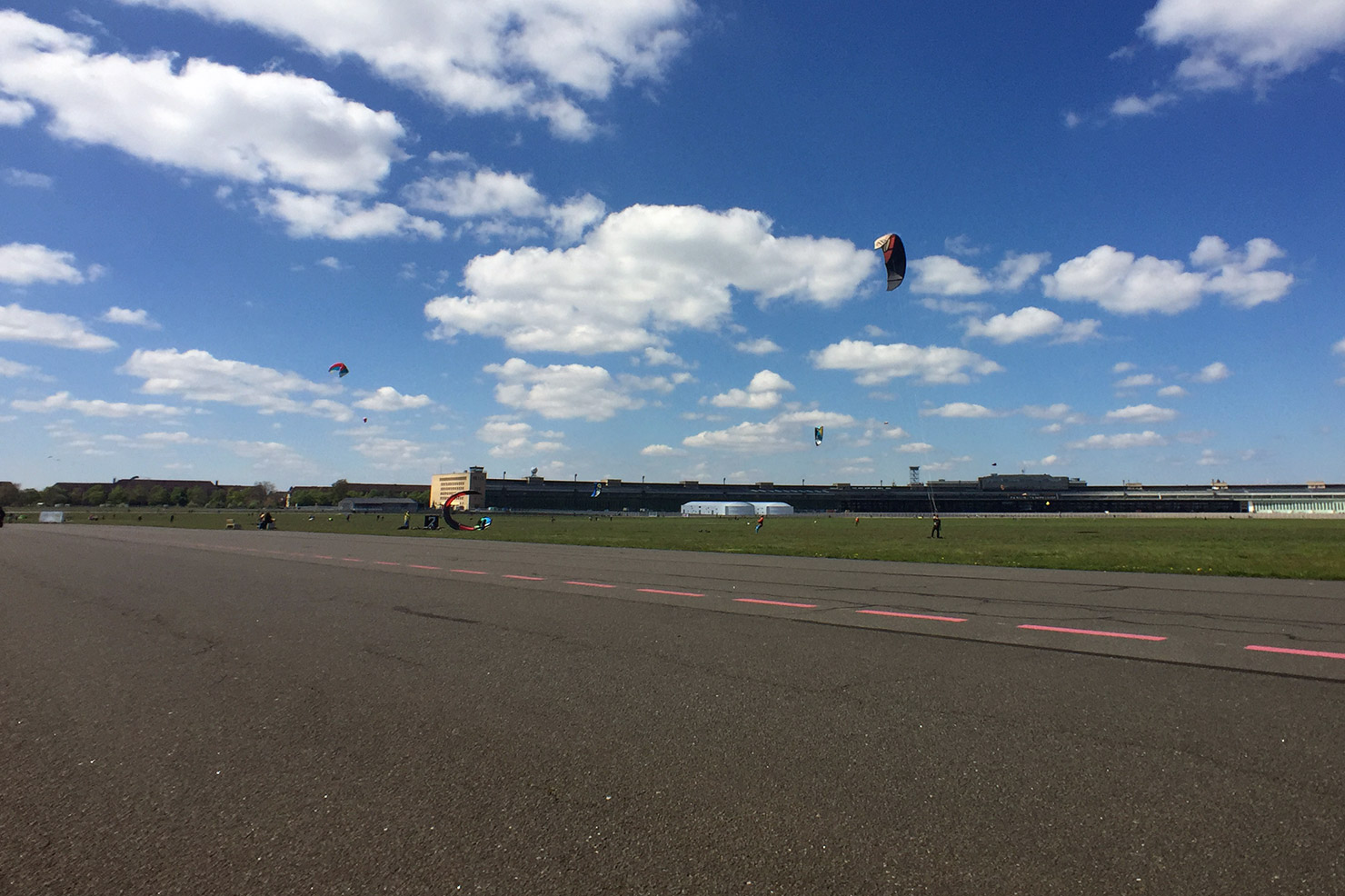
Whilst noting these cultural transplantations over coffee some months back, it became clear that we were now forced to review our lives through the grubby lens of Brexit, that calamitous antithesis to our respective biographies. Since we last met, a few dozen months ago, the world had staggered into a new era. May’s rudderless oblivionism, Trump’s bozo-kleptocracy and Putin’s rule-by-obfuscation were having the worrying side-effect of making Merkel’s strategy of “asymmetric demobilisation” [1] seem like a desirable advancement for democracy. Instinctively perhaps, as though searching for some kind of higher ground or an overview, we headed up to Tempelhofer Feld, Berlin’s former inner-city airport, now a public park and refugee shelter.
The Nazis built Tempelhof airport in typical geography-scale immensity. The terminal building looks terminal: nothing should have come after it. From a low earth orbit it might conceivably appear inviting, like the docking-station of a planetoid-sized electrical appliance. It’s belligerence is perhaps hereditary: it was erected on the site of a huge Prussian military parade ground. Earlier still, the land was part of a larger tract entrusted to an order of the Knights Templar, whose presence can be heard in the name: in 1200 or thereabouts they founded the village of Tempelhove (Temple’s yard) on the northern flank of the forested, sparsely populated Teltow Plateau.
At the end of the last ice-age, the Teltow Plateau rose up out of a vast meltwater river fed by retreating glaciers. It and the Barnim Plateau a few kilometers to the north define the swampy basin in which Berlin later took root. Two patties of pond-dappled clay, still perceivable today as steady inclines in the districts of Kreuzberg and Neukölln, Prenzlauer Berg and Friedrichshain.
With hindsight, and a weakness for the figmental, it seems plausible that Joe and I had been drawn upwards by subtle topographical indicators (the slant of the coffee in our cups), signalling a way up and out of the perceived political morass of our times. The café where we met is located at the foot of the ancient southern river bank. The name Berlin stems from the Slavic word for swamp, “Br’lo”, and it was out of this that we felt compelled to stride. Did twelve millennia of geomorphic change and anthropogenic drift represented the scale of context we needed in order to accommodate the present with any degree of calm?
On the old airfield, yolks of heathland stretch between the former runways. Skylarks bob out of the undergrowth in celebration of spring’s belated, crashing arrival. Leisure-class humans were celebrating their day of rest by revelling in the various configurations of wheels available to them for traversing short distances with as much elaboration as possible: kite-boards, long-boards, rollerblades, triathlon-bikes, tricycles. Even unicycles, piloted by precocious seven-year-olds, were scissoring about. A fiesta of ball-bearings, spokes and spandex. Strolling seemed a bit subversive, an affront to technique, a slight against every form of enhanceable, quantifiable recreation. How to improve upon the stroll other than by embracing its inherant resistance to optimisation?
Ordnance survey
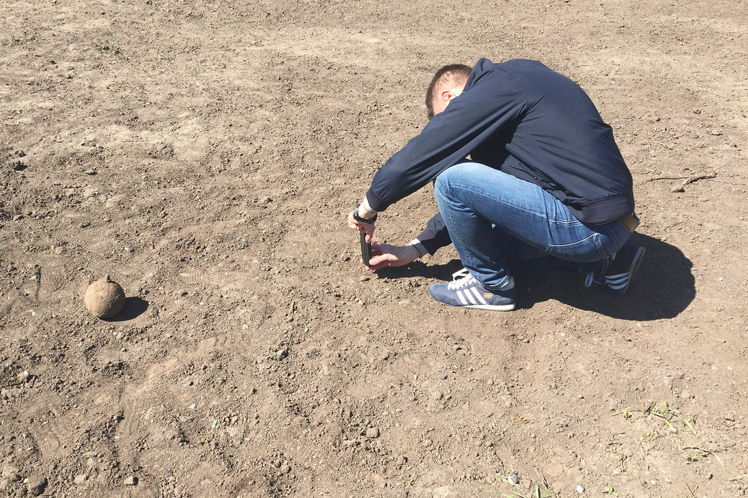
At the eastern end of the shorter of the two runways (09R/27L), Joe and I cross a patch of land where rows of defunct landing lights are held aloft on small, fenced-off platforms. The ground has been turned, prepared perhaps for some low-key landscaping project. We come across a rusty, dirt-encrusted sphere with a cylindrical appendage. It looks like a grenade. We wonder which public-service phone number might deal with unexploded ordnance. Perhaps unwisely we go for lunch instead.
Playdrive arsony
In the Schiller neighbourhood, we order Schiller Burgers at the Schiller Burger Bar. Sat outside at roughly hewn tables, we enjoy the perverse symmetry of the backdrop: the charred, melted wreckage of a Schiller-Burger-branded Smart Fortwo in the gutter. Car-grilled, toasted. Its burst windshield sags like a grease-drenched napkin, wisps of frazzled upholstery still cling to the skeletal remains of its bucket seats. Behind the car, a trail of scorched fragments stretches out into the road, as if it had been calmly parked whilst dramatically and terminally aflame. We speculate on the motives for such an attack: A skirmish in the war on gentrification, with the burger as signifier of malignant socio-economic forces. But perhaps the arsonist was making a philosophical point, synthesizing J. G. Ballard’s psychosexual auto-erotica with Schiller’s notion of Spieltrieb, or “play drive”: his unification of sensual and rational curiosity. Burning as learning. The dead Smart appears to be an outline for a hyper-local sci-fi narrative in which artisinal burgers will be grilled over the cobalt flames of self-immolating delivery drones, guided by the narrow-band whispers of hunger-prediction algorithms.
Walking the upland
We continue south into a semi-industrialised peninsular of suburbia wedged between Tempelhofer Feld, the A100 federal highway, the Teltow canal and railway lines which encircle the inner-city and once transported its domestic waste to outlying landfills. Yet amidst all these connecting arteries, the place feels appendicized, atrophied.
The payoff for walks guided by subliminal tokens (and the prize for shunning maps), is when the urban fabric begins to volunteer its neglected memories. Street names abhor metaphor, but a susceptive disposition is needed to adjust to their austere poetry. So when we hit Oberlandstraße, or Upland Street, it was clear that this simple toponym was confirmation that we had found our higher ground. We were in communion with the deep topography of the Teltow plateau. We were tuned to the ancient energies of meltwater peregrinations.
High-water mark
Joe mentions that he rents storage space on Oberlandstraße. But the flash of recognition is followed by disorientation. As we begin to head into the afternoon sun, it transpires that his mental map of the area has been formed at the road’s western intersection, whereas we were joining it at its easternmost point. His Berlin is momentarily flipped, south-up, like in the earliest maps of the city. Disorientation and self-storage sound to me like sure indicators of the peripheral, along with the tire shops, crane rental yards and heating-oil dealerships clustered along the canal. Anything which can be sold by the tonne or rented by cubic meter finds its economic niche here, safely above the high-water mark. But Berlin’s peripherality seldom demarcates the limits of the urban: it tends to bloom in tight clusters, confined by stronger forces, like moss in the mortared grooves of a brick wall.
Berlin’s peripherality seldom demarcates the limits of the urban.
One such strong force is the A100, Berlin’s stunted ring road. Work began in 1958, three years before the Wall spliced the city in two. In the earliest days of division, Western moral certainty held on to the narrative that Berlin would soon be reunified, and the A100 would encircle it like a wedding ring. The Cold War took a bit longer than the road’s masterminds had anticipated, but work progressed well into the 1980s, with the highway eventually girdling much of West Berlin. By the time reunification came, the population was suffering from utopia-fatigue. Completing the ring became impossible, with each sign of political intent swatted down by residents. Too costly the affair, too destructive for the communities affected by its course. The current and final phases will connect Neukölln with Friedrichshain (bridging the plateaus) at a cost of 130 million Euros per kilometre. And there the project will stall: a 270° arc of asphalt, an oxbow-motorway.
“So – come up to the lab / And see what’s on the slab.” Rocky-Horror-Modernism.
On Bacharacher Straße, having lagged behind Joe to fiddle with my camera, I find him standing aghast in the middle of the road, staring at an Italianate-style single family home the colour of off-brand vanilla ice-cream. He seems to be recalibrating his aesthetic world-view. Just as I’m beginning to offer a withering summary of Slab’s long and complex relationship with this kind of thing, the full tableau emerges. The Italianate folly is part of a three-house ensemble, each based on the same shell. One has undergone a vaguely Anglo/French makeover, with a vestigial mansard pitch to the roofline above the porch, and a faux-Edwardian garden fence. But the central house, a spec-box with few surface features, reveals the ensemble’s true genealogy. As a pure expression of the typology’s core functional specifications, it indicates that the pitched roofs and accoutrements of its siblings have no practical function. It’s a dressmaker’s doll waiting to be clothed by marketing consultants, a prototype, probably sold as “Bauhaus-style” to account for its lack of decoration. Nope: Modernism never went away, it just learnt how to cross-dress.
Dry springs and cross roads
We press on. Joe has introduced a goal to proceedings: the rumour of a brewery with a beer garden somewhere in the south-west. A recommendation, he says. As the afternoon warms up, abandoning the conventions of “drift” is an attractive proposition. At the prospect of beer, our trajectory tautens slightly. I propose a “fierce stroll”: the ambling character can remain, but the tempo is quickened.
The strategy of accelerated serendipity brings us to the courtyard of a 1931 housing complex designed by Gustav Hochhaus, where we discover an angular fountain in the expressionist style nestling in the courtyard vegetation. The triangular plinth houses a concrete basin on which tall pointed arches constructed from red Oldenburg brickwork rises above our heads. This Märchenbrunnen, or Fairytale Fountain, as it’s known, takes its geometric cues from the ribbed-vault ceilings of gothic cathedrals, but its dedication to watery animation feels more pagan than Christian. Like our cross-dressing spec-box houses, the fountain is a synthesis of the industrial and the folkloric. Hochhaus designed it with the sculptor Hans Lehmann-Borges, a member of the German Werkbund movement (motto: “From Sofa Cushion to Urban Development”). Unfortunately, water is missing from the fountain. So too the decorative tortoises, and the sculpture of a boy riding a dolphin which once formed its centrepiece [2], water-bound familiars from another realm.
The fairytail fountain, in the courtyard of the Gustav Hochhaus estate in Tempelhof
The trajectory of our journey superimposed onto an elevation map of Berlin. The white line marks the route undertaken on foot; the black line shows a short journey on the metro. The darker green area is the north-eastern tip of the Teltow Plateau. Central Berlin lies to the north, beyond the edge of this image.
The Upperland Street will bring us to Old Tempelhof. Who brought the Templar Knights there isn’t entirely clear, but Ascanian Margraves along with various dukes and archbishops form the parade of titled suspects. The decision was likely strategic. They had just given the market towns of Berlin and Cölln joint city status, exempting them from taxation [3]. The Templars (we should probably imagine armed monks) were allowed to set up commander’s courts across the Teltow plateau, on sites which would develop into the villages of Marienfelde, Mariendorf and Rixdorf. Connect the dots and a defensive chain of dwellings emerges, intended to ward off any meddling by the Duke of Schlesien or the Margrave of Meißen to the south-east. Christianising the local Slavs was a desirable side-effect.
In the Medieval Period, our route would have taken us through dense forest, but today it is comprehensively asphalted, paved, tiled over. With Old Tempelhof just ahead, and our backs turned to distant Rixdorf, we subconsciously plot the defensive vectors of old disputes, following the silent vibrations of territorial claims imperative to the invention of Berlin. The underlying topography is as obscured now by factories, warehouses and film-studios as it would have been back then by oak, lime, chestnut and birch. Crossing over the railway line which used to haul West Berlin’s household junk out of town and into a landfill on East German land, Joe and I stop and peer down into the cutting. It is flanked by the verdant progeny of that ancient woodland, and strewn with rubbish, yearning perhaps for the distant mound to which it once might have been relocated.
Detail of Schneider’s 1802 map of Berlin and environs
At some point between the Medieval Period and the industrial revolution, deforestation laid the underlying topography bare. An 1802 map by J.F.Schneider [4] puts us in an expanse of nothingness. This terrain-vague – territory described by an absence of the engraver’s tool – seems less like a passive side effect of urban expansion, and more like an active strategy of spatial-production inherent to industrialisation’s expansionist strategy. Maps create territory. Two paths are shown on Schneider’s map, one to our north, connecting Tempelhof with Rixdorf, and another south of the Teltow canal, connecting Tempelhof to Britz. These lines converge in the parking lot of Hansaflex, a hydraulic component manufacturer, meters from Joe’s storage space.
Moraine diving
The two lanes of Oberlandstraße split into four, and peel apart to form a long central reservation overgrown with horse chestnuts, lime trees and various bushes I couldn’t even begin to name, but which seem to be of the type which thrive on suburban diesel emissions or the electro-mechanical fug of the railway cutting. The island describes the historical core of Old Tempelhof, a one-street village surrounded by thin plots of agricultural land (hides) which radiated to the north and the south. The old plots are no longer distinguishable, and are now home to an eclectic mix of austere post-war condominiums, a slatted brutalist chunk of who-knows-what and, closest to the village’s midpoint, a couple of stern Wilhelmenian apartment buildings.
From here Joe and I descend into the pale moraine clay of the Teltow plateau. The metro takes us south to Alt-Mariendorf where we re-emerge through the downward flow of fleece-wearing pensioners. By systemising geographic space, diagraming only the flow through it, the U-Bahn scrambles delicate mental maps. [5] Strap-hanging between portals dug into the ground, we continue to probe Berlin’s defensive flank, obscured by its re-enlistment to the pragmatic reach of industrialisation: villages connected in a synaptic web, drawing rural populations into the urban conspiracy.
Our sense of displacement is anticipated by a bus shelter across the road: it has been designed to resemble feudal-era stables. No such mimicry for McDonald’s two block to the west, or the motor-scooter dealer, or the offset printer, or the next self-storage offering on the skyline.
Our inner-borough snobbery tells us we’re in the middle of nowhere, on the road away from cosmopolitain amenity. But two spherical high-pressure gas tanks looming behind a row of spruces soon mark our destination. We’ve arrived at Marienpark, formerly the Mariendorf Gas Works which for 96 years formed part of the industrial infrastructure of south-west Berlin. A lane takes us passed an old gatekeeper’s lodge and into a vast open space dominated by an imposing brick water tower erected in 1902. Instinctively, Joe and I take it in turns to pose for photos in front of the edifice, recognising its place-making qualities just as Berlin’s Monument Authority have done by preserving it. Most of the surrounding buildings were razed in the mid 1990s when the works were disbanded, but the remaining structures have been given the task of housing new economies, imbuing them with value-adding historical cachet. A little further to the north, sheep graze under the panels of a 2MW photovoltaic plant run by Berlin’s main natural gas vendor.
The author, shielding his eyes from the value-adding, post-industrial, historical cachet. Photo: Joachim Hetzel.
The old gas works are now a branded real estate asset managed by an entity calling itself 4 Projekte ZIM Asset Management GmbH. Marketeers have been busy: Marienpark has a logo (silhouettes of the local landmarks aligned into a lime-green hieroglyph), and an unavoidably bland motto (Raum für Ideen, “Space for Ideas”) which in a clever jujitsu-move, uses its own vapidity as a rallying call for speculation, reinvention, fermentation: Where there are brown bricks, there is inevitably craft-beer. Joe and I are thirsty.
Watering hole
The Stone Brewing Company is intermittently signposted, but we’re too absorbed by the iron framework of a Victorian-era gasometer and the slender, mushroom-topped 1960s New Watertower to care about an orchestrated arrival at the main entrance. We stumble onto the property from behind a fence, and startle five or six apron-clad kitchen staff smoking furtively next to a fire door. One of them indicates the direction with their cigarette and we step onto a huge split-level patio, where dozens of late-afternoon boozers sip beer from tulip glasses, and squint into the sunlight. Where had these people come from? Mariendorf had seemed depopulated; the approach to the brewery was just as quiet. The effect was theatrical. We were entering mid-scene, bystanders to a well developed plot, entirely indifferent to us.
The Victorian-era gas container, manufactured in London in 1900. The ultimate craft-beer backdrop.
Beers arrive, mine inappropriately dark (a black bulb, almost a meal), Joe’s more sensibly attuned to the gold light of the sinking sun and an encroaching crispness to the air. Our friendship goes back a couple of decades, and is happily undiminished by the scant contact we’ve had in that time. At days-end it appeared that the route we had trodden was a physical manifestation of our associative, free-wheeling conversation, a cartography of memory imbued by repressed geography. An urban drift is an act of simultaneous reading and writing, the contribution to a palimpsest of the personal and the communal. Space is thickened time, and passage through it a pan-chronic communion. Curb-stones will talk to you, as will the smoothly tiled perimeter wall of a biscuit factory, the litter in the undergrowth, the tilled soil of unfinished business, the prosaic chatter of street names, the disposition of the tarmac, the basin of a drained fountain.
A still quieter voice, intoned many octaves lower, at allegorical frequencies, kneads our psyche all the while. The plateau drew us upward into its folds, contravening thermodynamic law, gravity and baseline human laziness. It promises a synthesis of the mythical and the transitory modern. More must follow. Above the swamp, on the Teltow Plateau: nothing but broad fields and soft light.
[1] The term “asymmetrical demobilisation” gained popular notoriety in June 2017 after Martin Schulz, leader of the Social Democratic Party, used it in a speech to describe Angela Merkel’s political strategy. More info here (German language)
[2] A full description of Gustav Hochhaus’ estate on Oberlandstraße, including Hans Lehmann-Borges’ Märchenbrunnen, can be found on the Berlin Monument Authority’s website, here (German language)
[3] Cölln was the name of the settlement on the south bank of the river Spree, with Berlin on its north bank. In 1710 the two towns were merged by Kind Frederick I to form the capital of Prussia. The name Cölln lives on today in the southeast borough of Neukölln. Berlin im Mittelalter: Berlin/Cölln unter den Askaniern, by Norbert F. W. Meier. Berlin Story / Alles Uber Berlin, 2012
[4] J.F.Schneider, Plan von Berlin nebst denen umliegenden Gegenden
[5] Guy Debord speculates that the elimination of geographic distance is replaced internally by “spectacular separation”.
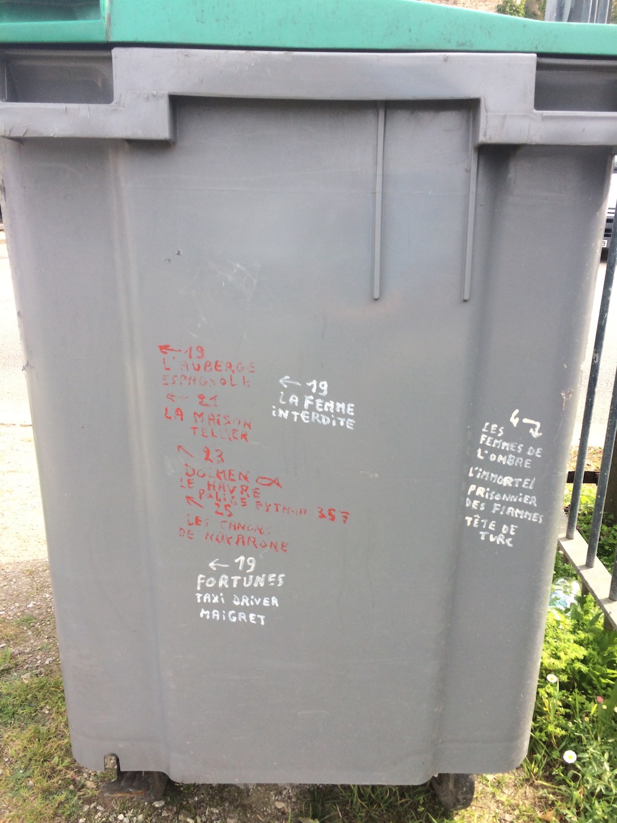
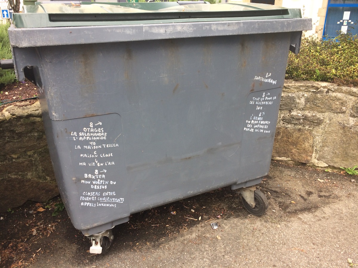
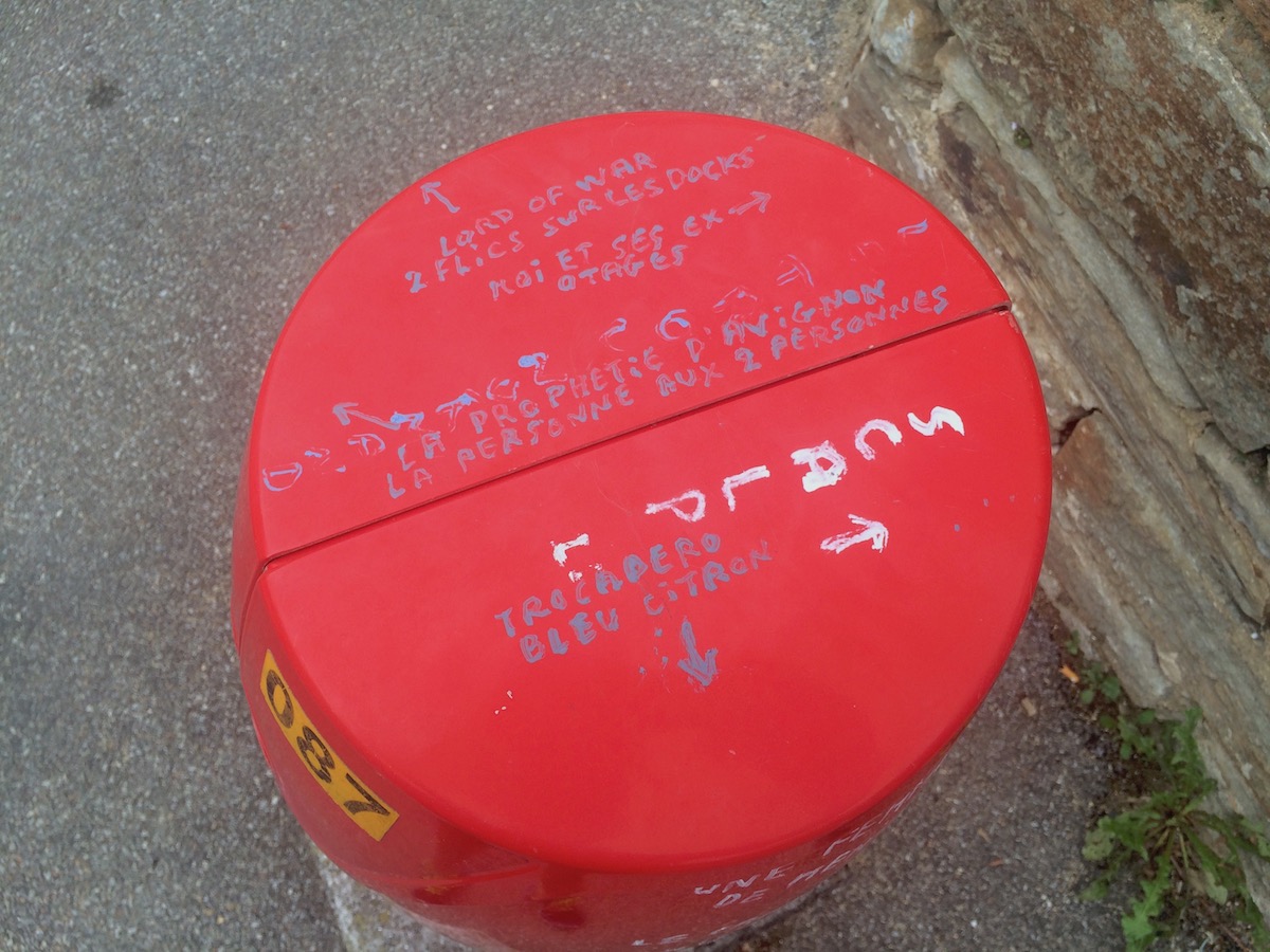
Douarnenez is a fishing town in the northwest of France. It is famous in particular for its fish canneries. Throughout the town, somebody has been writing the names of films on pieces of public furniture.
The balance of French/non-French film titles is about 50/50. There are thousands of titles, all in the same hand.
In some places, there is a numbering system in use, which your correspondent could not decipher. In other places, there are no numbers, just titles.
There is no apparent style, genre or taste in the titles that have been chosen. Opération Jupon refers to Operation Petticoat, a 1959 Hollywood comedy set on a submarine, where Cary Grant and Tony Curtis grapple with the unexpected cargo of five Army (female) nurses. Une nounou d’enfer is the 1990s American sitcom The Nanny, starring Fran Drescher. And Valparaiso is a French thriller from 2011.
There are also arrows, sometimes emanating from numbers, sometimes emanating from film titles. There is a system here.
Local journalist Marie-Line Quéau wrote up a piece about the unknown artist in the regional paper, La Télégramme, a couple of weeks ago. She interviews someone who spotted the “taggeur” at work in the middle of the night one time. She also quotes from Bruno Montpied, who described the graffiti in more detail on his blog, Le poignard subtil. The comments at the end of the piece are the best bit.
Video of the talk I gave at 2016’s Typo conference, held at the HKW in Berlin, has finally been released from password-protected seclusion. The theme of that conference was “Beyond Design”, which provided me with the narrow opening I needed to drop 40 minutes of psychogeography onto an audience otherwise invested in topics more closely related to typographic design.
In contrast to previous speaking engagements held in the context of architecture or urban design, it seemed helpful to provide the Typo crowd with something akin to an overarching hypothesis for the writings collected here. This writer has been shortcoming in that respect, aside from the somewhat dated and vainglorious effort provided by the About page. True to our strapline, this is a heuristic journal, braced for the inevitable pitfalls of not knowing where one is going, but keen to divulge the resulting narrative all the same.
Being forced to explain Slab Mag’s thrust was a gruelling, but ultimately rewarding endeavor. Whilst structuring the talk’s first 15 minutes, I hit upon the notion of the “phantom narrative” to describe the transient subtexts of our built environment, rendered legible only when critical reflection prioritizes the personal over the theoretical. Not long after this coinage, I stumbled across Werner Herzog’s Minnesota Declaration, in which the film director famously explained his theory of “ecstatic truth”, an elusive substance “reached only through fabrication and imagination and stylization”.
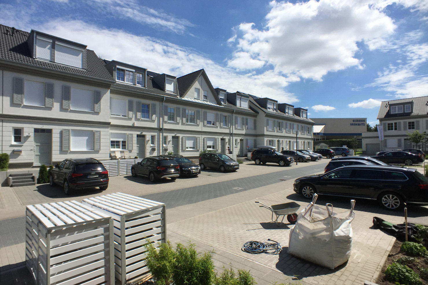
In den Leonorengärten is a newly built residential neighbourhood in Lankwitz, a locality in south-west Berlin. It seems perfectly situated; between a nursing home and a leisure center. In August of 2016 I drifted by, on my way down to a stretch of the Berlin Wall Trail which I’d not personally covered during research on Slab Magazine’s 2010’s investigation The New Death Strip. It was a gorgeous day, and trails need trailing.
Attracted by the developer’s sign on the main road, I approached Leonorengärten’s southern corner, where several hundred meters of gabion wall separated the estate from the adjacent swimming pool, tennis club and ice rink. A puzzling choice of material. Although perhaps “domesticated” to some extent by Herzog and de Meuron’s rigorous and contextually persuasive use in the 1995 Dominus Winery, gabion doesn’t easily shake-off its military heritage. Here, it seemed so at odds with the carefully staid idyll it had been installed to protect, that it resembled a copy/paste error, or the result of a misnamed data-object unwittingly mouse-dragged into a CAD-model. The alleyway which had emerged as a result of the wall being built, seemed already resigned to its new role as a future crime scene, best traversed with indifferent haste.
Before attempting to go beyond the wall, I briefly imagined the scene on other side. Freshly installed nuclear families luxuriating in the material and psychological fallout of behavioural patterns appropriated from American sitcoms, gardening magazines and last century’s beer commercials: couples lying prostrate on teak sunloungers, inebriate, basted with sun-cream and barbecue sauce, whilst a lawn sprinkler delivers arcs of water over a Weber propane grill and a Jack Russell Terrier quietly gnaws on a roller skate. Twisted images of middle-class, mail-order debauchery.
In a way I am the misplaced son of such imaginaries. I was once a sub-urban, commuter-belt-dwelling, BMX-riding, scuff-kneed, back-for-dinner-by-six, Cold War, latchkey kid. The ’70s-era Bracknell housing estate where my father and stepmother lived in the late 1980s was a dense landscape of bifurcating cul-de-sacs, arranged like the tightly packed, fractal blooms of a cauliflower. My radius of movement was asymmetrical, modestly sized, and mostly confined by the configuration of alleyways, gardens, fences, garages and gates established by the land-developer. Our neighbourhood had been built to feel like a discrete world. But on one occasion I broke the illusion, and all I needed to do was to slip through a hitherto unseen gap in a wall. On the other side was another neighbourhood: separate, familiar, yet oddly different. This breaching of zones was significant for its small lessons in agency and orientation: the expansion of my own spatial context – the feeling of setting – had previously been provided by adults at the wheel of a car.
Standing outside Leonorengärten, I wondered how such a transgression would unfold here: the gabion provided no such fortuitous gap for an inquisitive kid. Other narratives would emerge from this configuration of space.
An initial glance over the ramparts was encouraging: I spotted skeuomorphic window-shutters screwed onto the foam-insulated, synthetic-render façades. Decorative hinges were mercifully absent, but ventilation slats – perhaps too fundamental a feature – had been preserved. It occurred to me that slats’ function hadn’t been obliterated, but transferred. They were now rhetorical devices meant to evoke the shutteryness of a shutter, the houseyness of the house, and hence the collective memory and implication of the original.
The physical effort involved in using a real shutter denotes a communion between the body and the house. Shutters are closed at nightfall in mimicry of sleep, and darkness is banished to the outer world. At daybreak, shutters are thrown open with widespread arms: light, and the exterior world, are greeted with an embrace. But all of that has been held hostage in Leonorengärten by an amputated metaphor. Their very name, shutter, is redundant, for these shutters will never shut. All the same, the need to exercise control over light and shade remains, so each window has been equipped with a motorised roll-up which retracts into the façade.
The effect of this doubling was uncanny. Some roll-ups had been left ajar, causing the windows to simultaneously exhibit two mutually exclusive symptoms: temporary paralysis and rigor mortis. Worse still, adjacent windows shared a single decorative shutter, as though its reference object had been dysfunctional too, attached to the wall with hinges on both sides. In Make it Real – Architecture as Enactment, Sam Jacob calls such redundant appendages “technological glitches”, and suggests that we see “architecture’s re-enactment of history in the present as a kind of anachronic radicalism” [1]. Using a dead shutter to evoke a superficial cosiness might be a radical gesture (as if the houseyness of a house needed reinforcement), but I’m inclined also to see the enactment as a perverse form of malingering: the pretence of phantom limb syndrome, the desire for amputation.
But the anachronic radicalism of Leonorengärten’s enactive strategy seems to lie in its successful, and completely uncalled for smooshing-together of Tex Avery cartoons with a Beethoven opera. The fake shutters, the ham-fisted fluting and the dopey pitch of the roof remind me of the bug-eyed psychosis of a Daffy Duck animation, whilst the development’s name directly references the heroine and a key set-piece of Beethoven’s Fidelio: Leonore’s garden. You can see how the terraces might start swaying their rubbery bulk in time to the music. In Act I of the opera, Leonore, who is working incognito in the prison where her husband has been detained, convinces the guard Rocco to let the prisoners roam in the garden and enjoy the beautiful weather. “Oh what joy / in the open air / freely to breathe again!” the chorus sings.
Should we view the central configuration of gardens as an analogy to the prison yard? Would this explain the gabion perimeter? We can, of course, grant the developer, Interhomes AG, an awareness of Leonore: after all, the name is lifted from the main street Leonorenstraße [2], which runs through a neighbourhood often referred to as the composer’s quarter. But I’m doubtful the implied consequences of my analogy were factored in to the choice of name. Rather, the word “garden” just works well in Berlin, where property owners are easily convinced that living in the city and the countryside simultaneously is a realisable proposition. But this journal is dedicated to probing the limits of analogy, and insisting on deeper levels of legibility in the protocols of spatial production.
I freewheeled through the estate. I wondered why such huge houses should also appear so shrunken. There was a neat convenience to everything. Unsightly bins were housed in little wooden cages, empty deck chairs stood poised on the terraces, and the ground-cover was seamless. Whimsically, or sinisterly, one street was populated with black cars, and another predominantly by white vehicles. A single child wobbled about on roller-blades like a new-born foal. A family were actually in their front garden setting a table whilst the BBQ came up to heat.
In the context of Lankwitz, Leonorengärten’s aesthetic program (those “lavish façades in the style of garden-city architecture” [3] ), its economic narrative (single-investor splurge) and topography (semi-enclosed crescents) are singularly alien: a petri-dish community fallen from an investment portfolio. As such we should read it as the concentrated manifestation of a consensual, spectacular vision of suburbia; a meta-burb, a theatre set for the re-enactment of lifestyle-rituals, or an open laboratory for market researchers performing ethnographic house-calls [4], in which close observation of the residents’ interactions with shampoo dispensers, retractable-cord electric lawnmowers, mini trampolines and juicers can be made in a perfect simulation of a human’s natural surroundings.
[1] Sam Jacob, Make It Real – Architecture as Enactment, (Moscow: Strelka Press, 2012)
[2] On a side note, it’s worth mentioning that Leonorenstraße was named in 1937, four years into Nazi rule, in which Beethoven was enjoying slightly more popularity than Princess Victoria Adelaide of Schleswig-Holstein the Duchess of Sachsen-Coburg und Gotha, after whom it had originally been named. Link.
[3] Blurb from the website of property developer Interhomes AG. Link.
[4] For more on this, Slab can recommend Some Suggestions for Conducting Ethnographic Research, published in 2008 by Zwillinger Research, a market research group in Los Angeles, California. Link.
I encountered the turd on Arachovis Street, about one and a half blocks north-west of Asklipiou. I didn’t actually step into it: my peripheral vision had registered it moments previously, and I’d probably subconsciously classified it as geological feature best given wide berth. It really was an extraordinarily large turd: polymerous in structure, in fact, making it more of a turd-complex, or a compound-turd. A nobbled trunk of tremendous girth, poking upwards, adjacent to a slick of peaty, viscous gloop, which looked as though it had been troweled onto the pavement with great force.
Close encounters of the turd kind
For two more blocks I speculated about the turd’s origin. Sure, there was something vaguely anthropogenic about it, but the squalid chain of events leading up to its being excreted onto the middle of a pavement in Athens’ Exarcheia district was too unseemly to be plausible. On the other hand, I couldn’t image any other mammal capable of producing such a monument to its pitiable existence either, let alone one indigenous to this city’s streets. Surely no domestic dog could have produced that monstrosity. A large hyena, perhaps, or, hell – who knows? – a small rhinoceros.
Some days earlier, the owner of the deli on Kallidromiou explains how his great-grandfather had been quizzed about his decision to build a house in Exarcheia, probably around 1900. “There’s nothing but wolves up there”, a member of the family had warned him, projecting rural fears onto the endeavours of pioneering urbanites. Wolves: fine. May the turd be lupine.
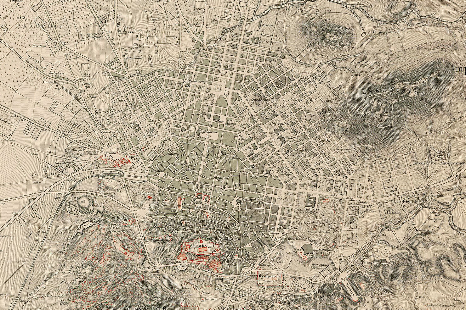
Athen mit Umgebung, Johann August Kaupert, 1875 (detail)
In 1895, Exarcheia was a growing suburb, creeping up towards the twin peaks of Lykavittos and Strefi. The area was named after an early resident from Epirus, a greengrocer by the name of Exarchon, whose store united urban demands with rural produce and helped spawn a neighbourhood. Long since home to writers, intellectuals and artists, Exarcheia today is renowned as the base for countercultural movements on the far left of the political spectrum. When 15-year-old Alexandros Grigoropoulos was shot dead by police in 2008, the ensuing riots were so fierce that Athens ran out of teargas. Now though, some feel that their neighbourhood has been encroached upon by pseudo-anarchists who see Exarcheia is a lawless playground where destructive urges can be lived out with impunity.