Australian Weather

National Summary
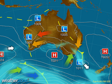
A cold front with a trough in the southeast is generating showers and thunderstorms, some severe. A trough stretching from WA to NSW is triggering showers and the thunderstorm. High pressure is keeping the south and southwest dry.
State Weather
Click for state forecasts


National Synoptic
Capital Cities
| NOW | MIN | MAX | ||
|---|---|---|---|---|
| Sydney | 23.7 | 20 | 25 | |
Showers |
||||
| Melbourne | 17.3 | 12 | 19 | |
Possible shower |
||||
| Brisbane | 24.2 | 20 | 34 | |
Possible thunderstorm |
||||
| Perth | 30.0 | 17 | 35 | |
Mostly sunny |
||||
| Adelaide | 20.4 | 12 | 20 | |
Clearing shower |
||||
| Canberra | 21.4 | 11 | 23 | |
Mostly sunny |
||||
| Hobart | 17.8 | 10 | 19 | |
Possible shower |
||||
| Darwin | 33.8 | 27 | 35 | |
Possible thunderstorm |
||||
Weather News
Eastern storms strike capital cities
14:58 EDT
Skies have darkened over Brisbane and Sydney this afternoon as thunderstorms rolled through both capital cities.
Damaging winds, large hailstones hit parts of Queensland
14:06 EDT
Wind gusts of up to 81 kilometres per hour have been recorded in Beaudesert as severe thunderstorms continue to bear down on south-east Queensland.
Queensland 2011 flood victims didn't try hard enough to save properties, Seqwater argues
00:31 EDT
Victims of the 2011 floods in south-east Queensland did not try hard enough to take their belongings to higher ground, dam operator Seqwater will argue in a large class action in the Supreme Court of New South Wales.


Extremes and Records
| Current Extremes | Last 3 Days Extremes | Extremes This Month | |||
|---|---|---|---|---|---|
| Tue 05/12 | Wed 06/12 | Thu 07/12 | |||
|
42.0°C Julia Creek Ap, Qld |
Hottest |
42.9°C Marble Bar, WA |
42.0°C Marble Bar, WA |
43.4°C Nyang, WA |
43.6°C Shark Bay Ap, WA |
|
1.9°C Mt Baw Baw, Vic |
Coldest |
1.8°C Oberon, NSW/ACT |
3.0°C Glen Innes Ap, NSW/ACT |
0.0°C Mt Baw Baw, Vic |
-1.7°C Mt Hotham, Vic |
|
NNW 61km/h Maatsuyker Is, Tas |
Windiest |
92km/h Wattamolla, NSW/ACT |
83km/h Thredbo Top Station, NSW/ACT |
94km/h Thredbo Top Station, NSW/ACT |
- |
| no rain last hr | Wettest |
63.6mm Kimbolton Range Station, WA |
64.4mm Deddington, Tas |
496.0mm Orbost, Vic |
53.0mm Ferny Creek, Vic |
| Australia's Records for December | |||
|---|---|---|---|
| Max | Min | Rain | |
| Highest 49.5°C at Birdsville Police Station, Qld in 1972 Lowest -0.8°C at Mt Buller, Vic in 2006 |
Highest 35.0°C at Marble Bar, WA in 1902 Lowest -9.6°C at Cooma Ap, NSW/ACT in 1990 |
Highest 711.0mm at Munglinup West, WA in 2010 |
|
-
Display your Local Weather here
automatically each time you visit us:

Rotates through Temperature,
Wind, Humidity and RainUse the Search Bar above
to find your Local, and go to the Local page
Click "Set My Local"
button next to the location name


