U.S. Volcanoes and Current Activity Alerts
-

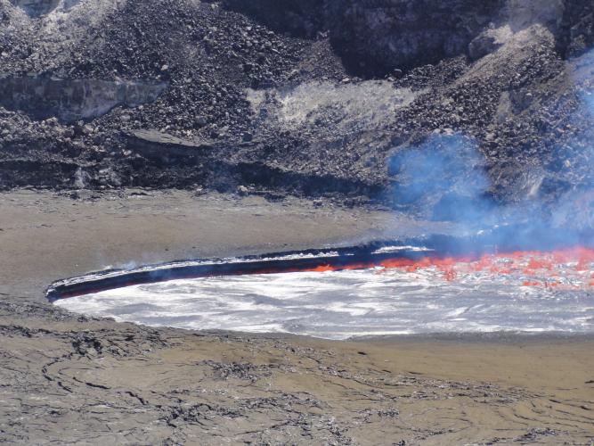
 The summit eruption in Halema‘uma‘u crater remains active. The lava lake is within the Overlook crater (the source of the gas plume), which is in the southeast portion of Halema‘uma‘u Crater.
 -

 Glow from The Halema‘uma‘u Overlook Vent Snuffed Out by Collapse
 -

 A small explosion from Kīlauea's summit lava lake in April 2015 was triggered by a rock fall from the Halema‘uma‘u Crater wall. This image was recorded by a webcam in the HVO observation tower.
 -

 Foundering of the lava lake crust is common near the lake's margins. The triangular-shaped slab of crust (left of photo's center) was sinking back into the lake as more fluid lava upwelled around it.
 -

 A closer look at Kīlauea's summit lava lake on Wednesday evening, around 6:30 p.m., when the lake was just 8 meters (26 feet) below the floor of Halema‘uma‘u Crater.
 -

 Typical lava lake activity at Kīlauea's summit, slowly rising lake level
 -

 Gas in the lava lake was rapidly released during the 10:20 am explosive event, causing the lava lake surface to drop a few meters (yards). This photo was taken moments after the explosive event, and
New Video: Kīlauea Summit Eruption | Lava Returns to Halema‘uma‘u
A new documentary video about Kīlauea Volcano in Hawai‘i, with behind-the-scenes imagery of publicly inaccessible areas, is available from the U.S. Geological Survey's Hawaiian Volcano Observatory.
Through historical photos of past Halema‘uma‘u eruptions and stunning 4K imagery of the current eruption, this 24-minute program tells the story of Kīlauea Volcano's summit lava lake—now one of the two largest lava lakes in the world. It begins with a Hawaiian chant that expresses traditional observations of a bubbling lava lake and reflects the connections between science and culture that continue on Kīlauea today.
The video briefly recounts the eruptive history of Halema‘uma‘u and describes the formation and continued growth of the current summit vent and lava lake. It features USGS Hawaiian Volcano Observatory scientists sharing their insights on the summit eruption—how they monitor the lava lake, how and why the lake level rises and falls, why explosive events occur, the connection between Kīlauea's ongoing summit and East Rift Zone eruptions, and the impacts of the summit eruption on the Island of Hawai‘i and beyond.
In March 2008, a new volcanic vent opened within Halema‘uma‘u, a crater at the summit of Kīlauea Volcano in Hawai‘i Volcanoes National Park on the Island of Hawai‘i. This new vent is one of two ongoing eruptions on the volcano. The other is on Kīlauea's East Rift Zone, where vents have been erupting nearly nonstop since 1983. The duration of these simultaneous summit and rift-zone eruptions on Kīlauea is unmatched in at least 200 years.
Since 2008, Kīlauea's summit eruption has consisted of continuous degassing, occasional explosive events, and an active, circulating lava lake. Because of ongoing volcanic hazards associated with the summit vent, including the emission of high levels of sulfur dioxide gas and fragments of hot lava and rock explosively hurled onto the crater rim, the area around Halema‘uma‘u remains closed to the public as of 2017.
The new video documentary is published as USGS General Interest Publication 182, and is available on the USGS Youtube channel.Field Guides Provide Insight Into Western Volcanic Regions
In preparation for the 2017 IAVCEI international scientific assembly in Portland, Oregon, researchers compiled extensive new field guides These interpret the dynamic volcanic landscapes of North American Cordillera — home to a greater diversity of volcanic provinces than any comparably sized region in the world. The guides were used during field trips surrounding the conference and provide field-based scientific explanation of volcanic processes and hazards to anyone who uses them.Volcanic Unrest is Persistent in Alaska and Hawaii
The Alaska Volcano Observatory website includes complete information about volcanoes in Alaska.- Mount Cleveland, located in the central Aleutian Islands, has been in a state of volcanic unrest since June 17, 2015. Explosive eruptions can send ash to altitudes hazardous to aviation.
- Bogoslof volcano, located in the central Aleutian Islands, is in a state of elevated unrest since eruptions began December 12, 2016. Eruptive activity is dominated by explosions that can put volcanic ash to altitudes exceeding 30,000 feet, resulting in ash cloud hazards to aviation.
- Kīlauea Volcano on the Island of Hawai‘i has been erupting from its East Rift Zone nearly continuously since 1983. Lava flowing into the Pacific Ocean presentsocean entry hazards to visitors. A second eruption began at the summit of Kīlauea in 2008 where an active lava lake produces occasional explosions and gas emissions that create Statewide vog hazards.
- Mauna Loa Volcano on the Island of Hawai‘i began showing signs of unrest in 2014, and the volcano alert level and aviation color code were raised on September 17, 2015. Elevated rates of earthquakes and ground deformation persist and HVO continues to monitor the volcano closely.


