Australian Chart Summary
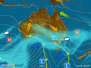
Monday - Latest
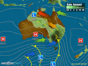
A cold front in the south is producing showers for souther SA, VIC and TAS. A weak trough in the east is bringing the odd shower to the the NSW coast. A front in the southwest if triggering the odd light shower for WA. High pressure is keeping elsewhere dry.
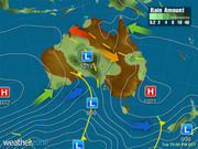
Tuesday 22:00 EST
A low pressure trough looks to produce patchy rain over VIC and TAS, while northerly winds bring warmth into NSW and QLD. A cold front approaching SA will cause brisk southwesterly winds to develop later. Onshore winds along the southern coasts of SA will bring a few showers.
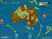
Wednesday 22:00 EST
A trough and cold front will begin to move through VIC and NSW and later in southern QLD; triggering a cool change, gusty winds, showers and possible storms. Brisk winds in the wake of this system will cause a few showers in SA and TAS. A high in the west is bringing a sunny day.
Thursday 22:00 EST
Brisk winds in the wake of a cold front will produce showers over parts of SA, VIC and TAS and eastern NSW. Warm air will remain over northern parts of the NT and WA. A large high pressure system will bring a sunny and stable day for most of WA, the NT and QLD.

Friday 22:00 EST
A cold front and associated low pressure system looks to cause gusty showers across TAS and VIC. A low pressure trough over inland QLD may produce the odd storm. Warm air lingers over northern parts of the country while a high should bring sunny and settled conditions elsewhere.

Saturday 10:00 EST
A cold front crossing NSW and VIC could bring showers to western VIC, southern NSW and TAS, whilst sending gusty winds along the coast. A cold front approaching the southwest may trigger a few showers. Skies elsewhere should be clear under a large high, leading a chilly night.

Sunday 22:00 EST
A low pressure trough moving over southern parts of SA could cause a few showers and storms, while moving warm air into eastern parts of SA. Onshore winds in the southwest may trigger showers. A high pressure ridge looks to bring a chilly morning and sunny day to the east.
Now Temperature
At Darwin Ap
22:10 CST
22°C
34°C
Sunny

Weather News
Hurricane Irma's force sucks shorelines bare, exposes sea beds
17:50 EST
People in Florida and the Bahamas have looked on in disbelief as the force of Hurricane Irma appeared to suck shorelines bare and expose sea beds.
Hurricane Irma: Images show extent of damage in US, Caribbean after record-breaking storm
16:54 EST
With maximum sustained winds of 298kph, Hurricane Irma wreaked havoc across several countries before weakening as it made landfall along the coast of Florida.
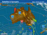
Spring warmth building in central Australia
16:25 EST
Most of Australia is cloud-free today and it's allowing temperatures to rise in the interior.

