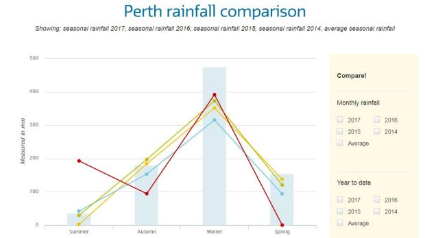
Perth has officially exceeded the August monthly rainfall average – 11 days clear of the end of the month.
The August average rainfall for the Perth metropolitan area is 135 millimetres, and the Bureau of Meteorology confirmed the region has officially reached 145 millimetres for the month on Sunday morning.

In August 2016, Perth only recorded 123.8 millimetres for the entire month.
The above-average rainfall is due to a series of heavy cold fronts rolling through the region throughout August, with some of the most severe storms bringing over 50 millimetres of rain in isolated areas.
The newest statistics mean Perth has also recorded its wettest winter since 2014, according to the Water Corporation.
The city experienced an unusually dry start to winter, with just 88 millimetres recorded for the entire month of June.
However July soon made up for the dry spell, with 172 millimetres dumped on the Perth region across the month – as opposed to July's 2016 average of 139 millimetres.
August has kept the ball rolling, with rainfall levels tipped to continue to rise before the end of the month.

Mandurah also recorded an unusual weather event on Saturday, with a rare "waterspout" forming over the suburbs of the town and Wannanup yesterday afternoon.
A waterspout is formed over water, and they travel like a tornado. They are often associated with high winds and severe weather.
Perth 7-day weather forecast
Sunday: 18, partly cloudy.
Monday: 9 - 18, shower or two. Rain: 1-3 millimetres
Tuesday: 8 - 19, partly cloudy, chance of shower.
Wednesday: 9 - 21, partly cloudy.
Thursday: 4 - 18, partly cloudy.
Friday: 10 - 21, partly cloudy.
Saturday: 11 - 21, partly cloudy.