Australian Weather

National Summary
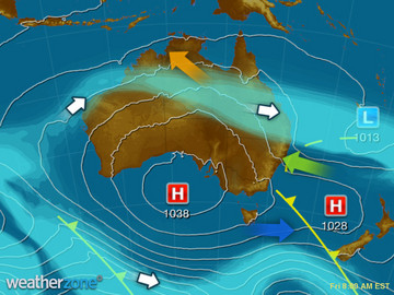
A cold front and trough over QLD and NSW are triggering showers and the odd storm, with brisk showers in its wake for southeast SA, VIC and TAS. A cold front approaching southwest WA is starting to produce showers and gusty winds. Mostly clear elsewhere under high pressure.
State Weather
Click for state forecasts


National Synoptic
Weather News
Cyclone Debbie: Federal Government offers $29m, not $110m in recovery payments
10:16 EST
Prime Minister Malcolm Turnbull has abandoned Queensland in its time of need after Cyclone Debbie, the State Government says, by refusing to pay tens of millions requested as disaster funding.
NZ wild weather on its way out
17:11 EST
After a three-day battle against the worst weather that winter can bring, there is some reprieve on the cards for New Zealand.
A bit of wet with the cold
11:44 EST
More winter showers are forecast for parts of southern Australia over the weekend, in addition to the already cold temperatures expected.


Extremes and Records
| Current Extremes | Last 3 Days Extremes | Extremes This Month | |||
|---|---|---|---|---|---|
| Wed 12/07 | Thu 13/07 | Fri 14/07 | |||
|
29.7°C Wyndham Ap, WA |
Hottest |
35.0°C Douglas River, NT |
35.0°C Wyndham Ap, WA |
35.0°C Wyndham Ap, WA |
36.0°C Bradshaw, NT |
|
-4.8°C Thredbo Top Station, NSW/ACT |
Coldest |
-10.0°C Thredbo Top Station, NSW/ACT |
-5.0°C Woolbrook, NSW/ACT |
-6.0°C Mt Buller, Vic |
-10.4°C Goulburn Ap, NSW/ACT |
|
WNW 62km/h Cape Leeuwin, WA |
Windiest |
81km/h Mt Read, Tas |
101km/h Thredbo Top Station, NSW/ACT |
100km/h Hogan Island, Vic |
- |
|
0.8mm last hr Hogan Island, Vic |
Wettest |
149.4mm Kempsey Ap, NSW/ACT |
50.8mm Mount Victoria, Tas |
58.0mm Ingham, Qld |
58.0mm Ingham, Qld |
| Australia's Records for July | |||
|---|---|---|---|
| Max | Min | Rain | |
| Highest 40.5°C at Tindal, NT in 1995 Lowest -6.9°C at Thredbo Top Station, NSW/ACT in 1978 |
Highest 27.1°C at Cocos Island Ap, WA in 2016 Lowest -19.6°C at Charlotte Pass, NSW/ACT in 2010 |
Highest 384.3mm at Nambour, Qld in 1973 |
|
-
Display your Local Weather here
automatically each time you visit us:

Rotates through Temperature,
Wind, Humidity and RainUse the Search Bar above
to find your Local, and go to the Local page
Click "Set My Local"
button next to the location name


