Australian Weather
National Summary
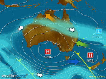
Low pressure troughs are generating patchy rain and thunderstorms over the central NT and QLD. A trough and front is in the southeast is moving away, allowing showers to ease for VIC and TAS. A high pressure ridge over SA and most of WA is bringing settled conditions.
Weather News
A year makes a lot of difference in regional NSW
12:43 EST
Last year, New South Wales enjoyed its third wettest winter on record, but this year is leaving the ground dry as chips.
Cyclone Debbie, three months on: How storm-hit towns in Queensland and NSW are recovering
11:54 EST
This week marked three months since Tropical Cyclone Debbie slowly hit the coastline of Queensland carrying windspeeds of 260kph.
Stormy Night for New Zealand
10:56 EST
Thunderstorms have flashed across the North Island overnight as a low pressure system bears down on Aotearoa.
Extremes and Records
| Current Extremes | Last 3 Days Extremes | Extremes This Month | |||
|---|---|---|---|---|---|
| Thu 06/07 | Fri 07/07 | Sat 08/07 | |||
|
28.3°C Wyndham Ap, WA |
Hottest |
36.0°C Bradshaw, NT |
35.7°C Kalumburu, WA |
36.0°C Wyndham Ap, WA |
36.0°C Wyndham Ap, WA |
|
-4.5°C Thredbo Top Station, NSW/ACT |
Coldest |
-8.0°C Cooma Ap, NSW/ACT |
-7.5°C Cooma, NSW/ACT |
-6.0°C Woolbrook, NSW/ACT |
-10.4°C Goulburn Ap, NSW/ACT |
|
NW 61km/h Low Rocky Point, Tas |
Windiest |
90km/h Neptune Island, SA |
83km/h Neptune Island, SA |
88km/h Hogan Island, Vic |
- |
| no rain last hr | Wettest |
38.4mm Leyburn, Qld |
34.0mm Uraidla, SA |
23.8mm Flinders Island, Tas |
24.0mm Meningie, SA |
| Australia's Records for July | |||
|---|---|---|---|
| Max | Min | Rain | |
| Highest 40.5°C at Tindal, NT in 1995 Lowest -6.9°C at Thredbo Top Station, NSW/ACT in 1978 |
Highest 27.1°C at Cocos Island Ap, WA in 2016 Lowest -19.6°C at Charlotte Pass, NSW/ACT in 2010 |
Highest 384.3mm at Nambour, Qld in 1973 |
|


