Smithsonian Collections Blog

Highlighting the hidden treasures from over 2 million collections

Collections Search Center

Thursday, May 11, 2017

A Case of Mistaken Identities: Ambrotypes of Potawatomi Chief Shabbona

Photographs of Chief Shabbona from the Iva Towsley Gardner collection of Chief Shabbona ambrotypes (NMAI.AC.100). National Museum of the American Indian, Smithsonian Institution.
One of the first lessons you learn as an Archivist is that you can’t always believe the information you are given, especially when it comes to photo captions. People are frequently misidentified in photographs and this information is often passed down through the generations. Such was the case with the Iva Towsley Gardner collection of Chief Shabbona ambrotypes (NMAI.AC.100) which we received as a gift earlier this year.

Iva Towsley Gardner (born circa 1899) served as a nurse in Illinois and often treated members of the Potawatomi community in her region. Someone within the community gave her a set of ambrotypes depicting Potawatomi Chief Shabbona and his wife from circa 1854-1859. A note, presumably written by Gardner, was attached to the set and reads, "Picture of Shabbona and his wife. Property of Iva Towsley Gardner."

Chief Shabbona (also spelled Shabonee and Shabni) was best known as a warrior and Chief of the Potawatomi tribe. Born circa 1775 to the Ottawa tribe, Shabbona is believed to be the grand-nephew of Ottawa Chief Pontiac (circa 1720-1769). As a young man Shabbona became an Ottawa chief and later married Coconako, the daughter of Potawatomi Chief Spotka. He eventually became a Potawatomi Chief himself.

Upon donation, we examined the ambrotypes in person and promptly determined that both photos depict Chief Shabbona, not Shabbona and his wife Coconako as the typed note indicated. Perhaps Gardner, or someone before her, mistook Chief Shabbona’s headdress for a woman’s feathered hat.

So the next time you’re looking through your family photos and see captions written by a relative long ago, just remember- you might want to take a second look


Emily Moazami, Assistant Head Archivist
National Museum of the American Indian, Archive Center

Wednesday, April 5, 2017

Three German Ships, Puerto Rico, and the Great War: the First Shots Fired by the U.S. in WWI

Theodoor de Booy in the Dominican Republic in 1916 (N04834).
In 1915, Theodoor de Booy, an archaeologist of the Museum of the American Indian, predecessor of the National Museum of the American Indian (NMAI), took photos of Old San Juan in Puerto Rico, which are now part of the Theodoor de Booy negatives and photographs collection. Included among this collection are photographs of three ships named S.S. Odenwald, S.S. KD-III, and S.S. Präsident. Considering this an oddity, I investigated further and what I discovered was a story that involved World War I, the Fortress of el Morro in San Juan harbor, a German scheme, and what many consider to be the first shots fired by the U.S. in the Great War.


The Fortress of El Morro guarding in the entrance of San Juan Harbor, 1915.
Photo by Theodoor de Booy (N04073).

Three Ships and a War

The story takes place in the harbor of San Juan between August 1914 and March 1915 when the U.S. was still a Neutral Power and Puerto Rico was already an American colony. The three ships were:


The S.S. Odenwald in San Juan Harbor, 1915.
 Photo by Theodoor de Booy (N04078).


The Odenwald, a German merchant freighter (a coal collier) that began to service the German Navy days after the beginning of the war. Her duty was to serve as support freighter for the cruiser SMS Karlsruhe whose mission was to patrol the eastern Atlantic in search of, raid, and sink enemy merchant vessels. She sailed into San Juan harbor around August 6 or 7, 1914, possibly seeking refuge against a British squadron of warships. Since the U.S. was a neutral state, it is possible that her crew claimed to be a merchant ship. But, the U.S. authorities seem to have been suspicious of these claims.


The S.S. Präsident in San Juan Harbor, 1915.
Photo by Theodoor de Booy (N04077).


The S.S. Präsident was a German vessel that served as a combination of passenger and cargo ship before the war. When the war broke out, she, too, began to serve in the German Navy as a support vessel to the cruiser Karlsruhe by providing radio communication and supplies. She arrived in Puerto Rico on December 1914 to take refuge from British and French cruisers that were hunting her and eventually was interned (to impound or confine until the end of the war) by the U.S. government.


The S.S. K.D.-III (Farn) in San Juan Harbor, 1915. P
hoto by Theodoor de Booy (N04079).


S.S. K.D.-III, a German tender ship that was actually the captured British coal collier Farn. While not at the service of the British Navy, she was carrying 3,000 tons of coal when captured by the Karlsruhe on October 1914 off the coast of South America. It was renamed K.D.-III (K.D. standing for Kohlendampfer or coal carrier). She sailed into San Juan on the 11th or 12th of January, 1915 to obtain supplies. Declared a tender boat of the German Navy on January 15, it was interned by the U.S. authorities.


Days Before the Incident

The story begins on March 18, 1915 when the captain of the S.S. Odenwald, C. S. Segebarth, requested (1) clearance to sail back to Hamburg the next day and (2) 5000 tons of coal for such trip. Suspicious of the request the local authorities decided to consult with Washington, D.C. and, afraid that the vessel may leave without clearance, alerted the commanding officer of the Porto Rico Regiment of Infantry (PRPI) at the fortress of El Morro. Washington approved the use of force if necessary and the German captain of the Odenwald was warned several times. Despite the Germans assurances that they did not intend to leave without clearance, the local authorities made preparations in case a situation developed. A machine gun platoon was placed on the Bastión de San Agustín, 500 feet from the Morro Castle (see plan of the Bay) commanded by Captain Wood and the heavy guns of El Morro were readied under the command of Lt. Teófilo Marxuach.


The Incident
On the afternoon of March 21, the customs inspector returned to the Odenwald, but his visit was cut short when the Odenwald started her engines around 3:00 pm and began moving on the main channel towards the mouth of the harbor without clearance. The custom collector was asked to leave in a small boat. As the Odenwald passed the Bastión de San Agustín, Captain Wood, standing on the parapet of the sea wall, hailed the vessel several times without success; the Odenwald stayed on course. Captain Woods ordered Puerto Rican Sgt. Encarnación Correa, to fire warning-shots with his machine-gun without any success. Failing to stop the vessel, Lt. Marxuach was ordered to fire a warning shot 300 yards across the bow of the Odenwald from El Morro’s 4.7 inch gun. This was the convincing shot and the Odenwald stopped and dropped anchor at the mouth of the harbor under the fortress. She was eventually moved that same day to the upper harbor with a local pilot.


Map of San Juan Harbor with annotations and calculations by Lt. Teófilo Marxuach for his report of the incident (National Archives).
Despite the fact that the U.S would not declare war to Germany for two more years, these shots have been considered by some American and Puerto Rican historians as the first ones fired by the U.S. in World War I. Perhaps, the main reason for this conclusion is that the whole incident took place within the context of the war. While not involved in the fighting, even the status of neutrality of the U.S. and other countries was the result of and defined by the conflict. Interestingly, these shots were fired by Puerto Ricans who did not become American citizens until Congress passed the Jones-Shafroth Act two years later in March of 1917.


L. Antonio Curet, Curator
National Museum of the American Indian


Wednesday, March 29, 2017

Hitler's Electron Microscope

Mama always said life was like a box of chocolates. You never know what you’re gonna get.
                                                                          --Forrest Gump, 1994
Archival material is like a box of chocolates because when you open an archival box you never know exactly what will be inside. Recently it was Adolf Hitler's electron microscope. Well, not the microscope itself, but the paperwork about the 1944 confiscation by Allied Forces of a Siemens electron microscope from the laboratory of Hitler's personal physician, Dr. Theodor Morrell, and its transfer and reassembly at the Army Medical Museum at Walter Reed.

An academic researcher at the Technische Universität Wien (Austria), where they are celebrating the 75th anniversary of electron microscopy, wrote asking for a description of several folders from our Rubin Borasky Electron Microscopy Collection, including Series 5, Box 7, Folder 17: Siemens Electron Microscope (captured in WWII).
The transmittal document describes the Siemens electron microscope as purchased by Adolf Hitler for Dr. Morell. The back story here is that Hitler was a hypochondriac in thrall to Dr. Morell, who supplied him with vitamins, hormones, and steroids. The strength of his hold over Hitler is reflected in the fact that there were perhaps only two or three of these Siemens electron microscopes in existence being used for atomic research. According to a 2009 book by two German historians (The Hitler Book: The Secret Dossier Prepared for Stalin / 2009 Henrik Eberle, Matthias Uhl), Morell hoped to use it to develop an explosive powder. He set up a laboratory in Bad Reichenhall, just at the foot of Berchtesgaden in Bavaria, where Hitler had built his Eagle’s Nest bunker.

The Eagle's Nest, Bavaria
Picked up by Allied Forces, Dr. Morell was taken from prison in Bad Reichenhall, Bavaria; he took them to the laboratory location in a fortified house on the outskirts of the town, where the microscope was found. The Army packed it up but later found parts were missing. Because of the missing parts, a second Siemens electron microscope was located and the parts from the two combined the make a single model for display. The microscope thus created is now part of the Billings Microscope Collection at the National Museum of Health and Medicine.

The National Museum of Health and Medicine website has a complete inventory of the Billings Microscope collection and a Siemens electron microscope appears on p. 151 of the PDF.

Christine Windheuser, Volunteer
Archives Center, National Museum of American History

Thursday, March 23, 2017

A British Ambassador in the Natural and Cultural Landscapes of Washington


The Castle (Smithsonian Institution Building) with grounds as landscaped by Andrew Jackson Downing. This illustration is from a publication of 1920, Washington the Beautiful. The National Mall was later created to be a long, open expanse of lawn, replacing the curvilinear paths and plantings of the mid-19th century. 

The District of Columbia, in the century following its selection by President George Washington as the site for the permanent seat of government, had a difficult history. The streets were muddy and unpaved, animals roamed about, the canal along what is now Constitution Avenue was a fetid sewer, a slaughter house was near the White House, and there was little in the way of infrastructure. Destruction that occurred from the War of 1812 and the chaos of the Civil War overwhelmed the city’s scant resources and contributed to the Federal capital’s sorry state. There were calls to have the Capital moved elsewhere. Washington City began to become more established with the creation of the Territorial Government in 1871, led by Alexander “Boss” Shepherd, although that municipal organization soon collapsed under scandal and bankruptcy.

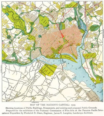
The “City Beautiful” movement, growing out of the 1893 World Columbian Exposition, inspired, in part, the 1901 Senate Park Improvement Commission to draw up the McMillan Plan, an architectural reshaping of the National Mall and park system throughout the city. Never formally adopted due to political maneuverings, the 1902 document nonetheless has served as a guide over the decades towards realizing (if in piecemeal form) the grandeur envisioned in Peter (Pierre) Charles L’Enfant’s 1791 plan of District, with monumental buildings and memorials.


Plan for redesigning Washington in 1915. A row of official government buildings line the Mall (note the absence of the Castle). This plate is from William H. Taft and James Bryce's Washington, the Nation's Capital.

A key participant in the landscape and beautification of the nation’s capital was Ambassador James Bryce of Great Britain. Serving from 1907 to 1913, he was an articulate, energetic and persuasive proponent of what made and would make Washington unique in the world. He made his first of many travels to America in 1870, and arrived to his diplomatic posting in Washington with a wide circle of friends and well known from his popular three-volume The American Commonwealth (1888). Following in the footsteps of Alexis de Tocqueville’s Democracy in America (1835-40), Bryce’s classic work analyzed government, economic and social institutions across the United States. Having been a law professor at Oxford, well-traveled across the globe, and a politician (as a Liberal Member of Parliament), Bryce was said to have read everything and known everyone. Unlike some others with sophisticated backgrounds filling ambassadorships in Washington at this time, he embraced with confidence what was a decidedly backwater town.

James Bryce, Viscount Bryce of Dechmont (1838-1922). Portrait frontispiece from his book, The Nation's Capital
As a younger man, Bryce was an avid mountain climber, having summited Mount Ararat in Turkey in 1876; he served as president of the Alpine Club (UK) from 1899 to 1902. Although no longer young, he brought this rigorous appreciation of the outdoors to Washington and explored its natural setting and surrounding rural countryside with great enthusiasm. As with many a foreign visitor today, Bryce was in awe of the surging rapids fourteen miles upstream: “No European city has so noble a cataract in its vicinity as the Great Falls of the Potomac—a magnificent piece of scenery which you will, of course, always preserve.” Indeed, the country has: the waterfalls, with their southern banks in Virginia and northern parts in Maryland, including the Chesapeake and Ohio Canal, are maintained by the National Park Service.

Postcard of Boulder Bridge in Rock Creek Park (1911). Smithsonian Institution Archives, Negative Number SIA2011-2307. 
It was Rock Creek, now one of the largest forested urban parks in America—twice the size of Central Park in New York City—that Ambassador Bryce was particularly taken with and not shy about expressing his opinions and offering advice. The meandering woodlands start at the Georgetown Canal and now extend into Montgomery County in Maryland, with many tributary park extensions, including Dumbarton Oaks Park.

During the 19th century, there were serious proposals for building a railway and for filling in the valley of Rock Creek to the level of Massachusetts Avenue in the Northwest quadrant of the city. But thoughtful urban planning led to the creation of Rock Creek Park by an Act of Congress in 1890, one of the early federal parks in the country (the third in the system). It was the creation of the Smithsonian’s National Zoological Park on the banks of Rock Creek, with legislation enacted in 1899, which brought greater public attention to the need for protecting wildlife in the region and land for recreational use. Bryce praised Rock Creek’s “inexhaustible variety of footpaths, where you can force your way through thickets and test your physical ability in climbing up and down steep slopes.”

Visitors to the Zoo Relax by Rock Creek. Smithsonian Institution Archives, Negative Number 75-1702.
At a Board of Trade meeting in 1912, he warned that the beautiful spots of Washington could be ruined if acts of preservation were not soon taken. He scolded members of Congress for concentrating on appropriations for their home districts while ignoring their capital city. In support of constructing a touring road from the Zoo to the Potomac River, he was quoted saying to the group that “It seems to me that one of the principal endeavors of all people who want Washington made the greatest capital in the world should be to maintain the beauty of Rock Creek Park” (Washington Post, 1 March 1912). The following year, he proclaimed:
I know of no great city in Europe that has anywhere near such beautiful scenery so close to it as has Washington in Rock Creek park, and in many of the woods that stretch along the Potomac on the north and also on the south side. The river in the center, beautiful hills, delightfully wooded, rise on each side and one may wander day after day in new walks. I never have to take the same walk twice. (Washington Post, 28 February 1913)
 
Bryce’s “touring road” was extended into Maryland and has become a major commuting route for cars, with the creation of Rock Creek and Potomac Parkway which was authorized by Congress in 1913. This lengthen the road from the National Zoo down toward the Potomac River, effectively linking it with the National Mall and the growing campus of museums and monuments. 

Bryce strongly advocated the extension of Rock Creek above Washington into Maryland where “There are leafy glades where a man can go and lie down on a bed of leaves and listen for hours to the birds singing and forget there is such a place as Washington and such a thing as politics within eight miles of him.” He foresaw, in the great growth of the United States, that Washington would become a large and world-class city despite its lack of industries.
William H. Taft and James Bryce's Washington, the Nation's Capital

In a 1913 essay presented to the Committee of One Hundred on the Future Development of Washington, the Ambassador pleaded for preserving a certain vista:
May I mention another point of view that is now threatened and perhaps almost gone? You all know the spot at which Wisconsin avenue (up which the cars run to Tennallytown and the District line) intersects Massachusetts avenue, which has now been extended beyond that intersection into the country. At that point of intersection, just opposite where the Episcopal [now known as National] Cathedral is to stand, there is one spot commanding what is one of the most beautiful general views of Washington. You look down upon the city, you see its most striking buildings—the Capitol, the Library, State, War and Navy Department, and the Post Office and other high buildings along Pennsylvania Avenue—beyond them you see the great silvery flood of the Potomac and the soft lines fading away in dim outline in the far southeast. It is a delightful and inspiring view.
Believing there was no better vantage point in Washington, Lord Bryce stated that this slope should be turned into a public park, and the houses stretching below limited in height to protect the sweeping view. This northwest corner of Washington was becoming fashionable, growing as older parts of the city became more built up. After an initial period of recovery following the Civil War, during a time of wild economic growth (1880-1920), the Federal Government quickly expanded and new official buildings pushed residential neighborhoods out of downtown. With its hilly terrain and seclusion provided by the ravine of Rock Creek, yet so close to the old Washington City, the area was a perfect location for newly wealthy Americans to build luxurious private estates and gardens. Land speculation was booming. The Ambassador’s cherished vista, since so many trees were cut down during the Civil War to defend the vulnerable city with forts and roads and clear lines of sight, would eventually be lost to subsequent tall tree growth. Nor did he anticipate that that acreage would soon become so very valuable. In a mere fifteen years from the time of Lord Bryce’s suggestion, his own country would ignite a trend of foreign missions in the area with the new British Embassy, designed by world-renown architect Sir Edwin Lutyens.


Lord Bryce (who, after his retirement as ambassador, became Viscount Bryce) is often quoted in the literature of Rock Creek Park, remembered for his eloquent advocacy of the city that was only one of his many diplomatic postings. His legacy rather sadly lives on in the neglected terraced Bryce Park, dedicated by Princess Margaret in 1965. It is located at what once was his favorite spot, now the busy intersection of Wisconsin and Massachusetts Avenues but without the sweeping views. It is less than a mile from the British Embassy.


The Smithsonian’s collections provide testament to James Bryce’s legacy and lessons: there are several bronze sculptures (as well as a bust in the Capitol Building), an indication of his prominence at the time, and a dozen of his authored works in the Libraries. It is those titles, as well as his quotes accessible in historical newspaper databases and in journals, that record his thoughtful and forward-looking advocacy of the natural environment of Washington. They all preserve the history that informs the metropolitan landscape of today, the extensive park system first envisioned by L’Enfant.


Julia Blakely
Special Collections Cataloger
Smithsonian Institution Libraries


Notes and Captions 

One of the more famous quotes of Ambassador Bryce is that "The national park is the best idea America ever had.”
Washington, the Nation's Capital
Bryce Warns Capital: Says It May Suffer Through Neglect of Congress.” The Washington Post, March 1, 1912, page 3.
  
Bryce, James. The nation’s capital. Washington, D.C.: B.S. Adams, 1913.

Taft, William H. with James Bryce and Gilbert Hovey Grosvenor. Washington, the Nation’s Capital. Washington, D.C.: National Geographic Society, 1915.

“[You] have an admirable and constantly growing National Museum.”

Completed in 1911, the building is now the National Museum of Natural History (Washington the Beautiful)
Bryce: “I know of no city in which the trees seem to be so much a part of the city as Washington.”


Washington’s Chamber of Commerce’s Committee of Hundred on the Future Development of Washington was to promoted the plan of the capital as approved by George Washington and as expanded by the Park Commission. The speech by Bryce delivered to the Committee was printed and edited for publication (newspaper accounts provided variations of the text) by Washington architect Glenn Brown. Photographs illustrating the book were by A. G. Robinson. A later reprint appears in The Capital of Our Country (National Geographic Society, 1923).

Friday, March 17, 2017

Opening the Archives: New Finding Aid Available at the Eliot Elisofon Photographic Archives, National Museum of African Art

Celebrating Artist Betty LaDuke, Multicultural Women’s Art Advocate

In most [of my] paintings, African women are portrayed between myth and reality. They are mothers bringing forth, sustaining, and nurturing all life forms. They are cultural guardians, healers, and mythical goddesses. These strong and resilient role models are my praise songs to Africa.”
-Betty LaDuke, Artist Statement from Celebrating Africa – Celebrating Life Exhibit
There is no better time to share Betty LaDuke’s photographs, artwork and teachings than during Women’s History Month. An artist, photographer, writer, professor and multicultural women’s arts advocate, Betty LaDuke has worked for over thirty years to promote women and international artists.
Kunama Mother Carrying Child on Back,
Barentu Region, Eritrea, circa 1994
EEPA 2007-003-250


Born in the Bronx to Russian and Polish immigrants in 1933, LaDuke attended California State University in Los Angeles and the Otis College of Art and Design. After three years of teaching junior high art in East Los Angeles, LaDuke moved to Ashland, Oregon in 1964 to accept a position in the art department at Southern Oregon University, where she taught for over 30 years. The University’s second woman art teacher (and for eighteen years the only woman in the Art Department), she strove to increase awareness of international women artists and humanitarian concerns, teaching courses including “Women and Art” and “Art in the Third World”. 

"NAKFA Survivors"
[Taken during the Border War in an Internally Displaced Persons Camp],
Nakfa, Eritrea, 2001
EEPA 2007-003-2508


In addition to teaching, LaDuke published numerous books on women’s art, including Compañeros, Women, Art, and Social Change in Latin America (1985) and Africa: Women’s Art, Women’s Lives (1991), Africa through the Eyes of Women Artists (1991), and Women Against Hunger: A Sketchbook Journey (1997).  LaDuke herself has been the subject of a book by Gloria Feman Orenstein, entitled Multi-Cultural Celebrations: The Paintings of Betty LaDuke 1972-1992 (1993).

But her stunning artwork, full of uncompromising representations of women's struggles and resilience, is by far the most impactful source of advocacy. Beginning in 1972, she began to undertake annual research journeys to Asia, Latin America, Oceania and Africa, photographing and sketching the women and children in those regions, finding inspiration for the paintings and prints that would make up her circulating exhibits. Engaging with these themes, LaDuke produced traveling exhibits, notably Landscape: A Feminine Mythical View and Africa Through the Eyes of Women.
"Eritrea-Ethiopia: Where Have all the Father's Gone?" Print by Betty LaDuke
EEPA 2007-003-2649
Upon her retirement from teaching in 1996, LaDuke began to travel to project sites of Heifer International, a humanitarian organization concerned with world hunger and environmental sustainability. These experiences inspired a new phase of her work, including a return to mural painting. Today, LaDuke and her husband live in the home they built in Ashland over forty years ago.


Basket Makers, Senafe, Eritrea, 1998
EEPA 2007-003-2493
LaDuke’s influence is still certainly seen in her daughter’s renowned activism and political influence: A two-time vice presidential candidate with Ralph Nader for the Green Party (1996 and 2000), Winona LaDuke is internationally recognized for her work on issues of sustainable development, renewable energy, environmental justice and food systems, particularly for indigenous communities. Founder of the White Earth Land Recovery Project, one of the largest reservation-based non-profit organizations in the country, Winona, like her mother, has dedicated her life to advocating for human right's issues. Winner of such prestigious honors and awards as the Reebok Human Rights Award (1988), the Thomas Merton Award (1996), Ms. Woman of the Year (with the Indigo Girls) (1997) and named to Time magazines' America's fifty most promising leaders under forty years of age list, Winona continues her incredible record of activism, now working towards a peaceful resolution to the North Dakota pipeline conflict.

Betty LaDuke and Children, Eritrea, circa 1998
EEPA 2007-003-2719
For more information about Betty LaDuke, see her website.


Betty LaDuke Collection 
EEPA 2007-003

Consisting of over three thousand color photographs and negatives, 24 art prints, posters, a copy of a sketchbook, biographical materials, exhibition files, publications, and two DVDs, LaDuke's collection provides insight into her travels and work between 1981-2009. Photographing in Ethiopia and Eritrea, particularly in Senafe, Nakfa and Massawa, the images largely depict Kunama and Saho peoples, especially women and children, but also document architecture, agricultural work, beadwork, weaving, village scenes, artists, artists at work, artworks, markets, celebrations, scenic views, animals, churches and mosques. Some of LaDuke's most potent images portray embattled Internally Displaced Persons (IDP) camps during the Border War, especially those in Nakfa and Gelebe (see photo above).

For more information on the Betty LaDuke Collection, please see our finding aid to learn more about the photographs, art prints, A/V materials, exhibition files, printed material, and biographical records that comprise the collection.

To request an image, please see our website for the photo request form. To make an appointment at the Eliot Elisofon Photographic Archives, please email elisofonarchives@si.edu. Our research hours are Monday through Thursday, 10 AM to 4 PM.

Eden Orelove, Photo Archivist