Australian Weather
National Summary
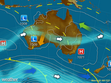
The monsoon trough and tropical low in the north is generating heavy rain, storms and gusty winds for parts of the NT. An offshore low is directing cold and showery winds along the NSW coast. A cold front will brush the southwest corner, bringing a few light showers.
Weather News
Sydney swell builds
14:03 EST
Wave heights have increased rapidly near the central coast of New South Wales today.
Darwin approaching wet season record
11:56 EST
Darwin's prosperous wet season is about to receive another burst of rain as the threat of a tropical cyclone looms for the Top End.
Top End cyclone threat
15:56 EST
Australia's late-season cyclone surge continues this week and Darwin may be impacted in the coming days.
Extremes and Records
| Current Extremes | Last 3 Days Extremes | Extremes This Month | |||
|---|---|---|---|---|---|
| Sun 09/04 | Mon 10/04 | Tue 11/04 | |||
|
28.6°C Rowley Shoals, WA |
Hottest |
40.0°C Mandora, WA |
40.2°C Carnarvon Ap, WA |
39.0°C Carnarvon Ap, WA |
40.2°C Carnarvon Ap, WA |
|
2.2°C Mt Wellington, Tas |
Coldest |
-3.2°C Thredbo Top Station, NSW/ACT |
-1.8°C Thredbo Top Station, NSW/ACT |
-4.6°C Liawenee, Tas |
|
|
SSE 50km/h Wattamolla, NSW/ACT |
Windiest |
120km/h Falls Creek, Vic |
105km/h Mt Hotham, Vic |
81km/h Wattamolla, NSW/ACT |
- |
|
0.6mm last hr Cocos Island Ap, WA |
Wettest |
100.0mm Durdidwarrah, Vic |
222.4mm Warruwi, NT |
222.4mm Warruwi, NT |
|
| Australia's Records for April | |||
|---|---|---|---|
| Max | Min | Rain | |
| Highest 45.0°C at Marble Bar, WA in 1928 Lowest -5.6°C at Thredbo Top Station, NSW/ACT in 1978 |
Highest 32.0°C at Pannawonica, WA in 1981 Lowest -17.4°C at Mt Hotham, Vic in 1991 |
Highest 800.9mm at Port Douglas, Qld in 1911 |
|


