
Strong wind gusts and "sideways rain" have lashed Sydney and the Central Coast, leaving more than 33,000 homes without power.
The weather wreaked havoc on transport on Wednesday afternoon, with lightning strikes, downed trees and heavy rain causing delays on roads and across the Sydney Trains network.
More NSW News Videos
- Video duration
- 00:51
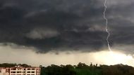
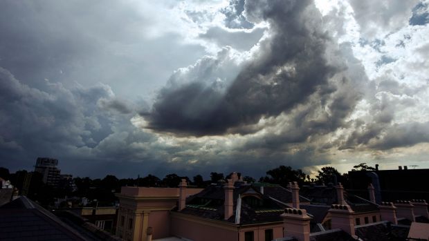
Sydney lashed by storm
Sydney lashed by storm
A huge storm front has made its way across Western Sydney and the Central Coast.
Up Next
Missing propeller recovered from Bushland

- Video duration
- 00:42

- Video duration
- 00:42
Missing propeller recovered from Bushland
Missing propeller recovered from Bushland
The propeller that came off a Regional Express plane has been recovered from bushland in Revesby in Sydneyâs south-west, after it came loose and narrowly missed hitting the REX flight.
Up Next
The Central Walk
- Video duration
- 01:04

- Video duration
- 01:04
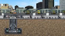
The Central Walk
The Central Walk
Transport for NSW vision shows plans for a pedestrian concourse under Central Station, to commence construction in 2018.
Up Next
Teen charged over alleged assault filming

- Video duration
- 01:37

- Video duration
- 01:37
Teen charged over alleged assault filming
Teen charged over alleged assault filming
A 15-year-old student has been charged after he allegedly filmed the assault of a girl in Bellevue Hill and posted it online. Vision: Ten News
Up Next
Siege ends after marathon stand-off

- Video duration
- 00:30

- Video duration
- 00:30
Siege ends after marathon stand-off
Siege ends after marathon stand-off
A man suspected of a crime spree, including a triple stabbing at a Sydney gym, has been been arrested following a long stand-off with police in Newcastle. Vision courtesy Seven Network.
Up Next
Sydney man awarded $3000 for false imprisonment

- Video duration
- 01:32

- Video duration
- 01:32
Sydney man awarded $3000 for false ...
Sydney man awarded $3000 for false imprisonment
A court  has awarded a Sydney man $3000 for being stopped by police for four minutes at Liverpool train station.
Up Next
Young man feared drowned

- Video duration
- 01:23

- Video duration
- 01:23
Young man feared drowned
Young man feared drowned
A 23-year-old international student is feared drowned after being swept-out in a rip at Newcastle Sunday night. Vision: Network Ten
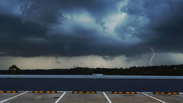
Sydney lashed by storm
A huge storm front has made its way across Western Sydney and the Central Coast.
Volunteers from the State Emergency Service have responded to more than 400 calls for help since bands of storms began to sweep across the city just in time for the evening commute.
The Bureau of Meteorology warned in a severe thunderstorm warning that heavy rainfall, large hailstones and damaging winds were heading for the city. (See bureau map below.)
Storms were forecast to affect a vast area including Wollongong, Kiama, Camden, Campbelltown, Dapto and Port Kembla by 4.40pm and Sutherland, Sydney Airport, Sydney Olympic Park, Engadine, Liverpool and Helensburgh by 5.10pm.

Lightning and strong winds disrupted power to more than 33,000 homes and businesses "at the height of the storm", mostly in Mount Druitt and the Hills District, power company Endeavour Energy said.
The SES was called to 160 reports of storm damage in Mount Druitt, as well as conducting flood rescues.
"The most significant damage has been in the suburbs in and around Plumpton where lightning interrupted all supply from the major substation providing electricity to the area," Endeavour said in a statement.
"This affected power to 14,000 homes and businesses across Whalan, Lethbridge Park, Rooty Hill, Bidwill, Blackett, Shalvey, Dharruk and Emerton."
Trees have also brought power lines down across the city, with crews expected to work late into the night making repairs.
A large tree was ripped from the ground in Castle Hill, falling on a fire hydrant and causing it to spray water, as hundreds of lightning strikes hit around Sydney.
#SydneyStorm pic.twitter.com/tMkcITsOuI
— Deepak Kapoor (@_DeepakKapoor) March 22, 2017
Thunderbolts and lightning... #SydneyStorm #NSWstorms #weather #nswrfs pic.twitter.com/7ZzElz4kEB
— NSW RFS (@NSWRFS) March 22, 2017
Endeavour said the "widespread extent" of damage means some homes will remain without power overnight.
From 9am to 6pm on Wednesday, 42 millimetres of rain fell at Lidcombe, with 46mm at Appin, 44mm at Sydney Olympic Park and 30mm at Baulkham Hills.
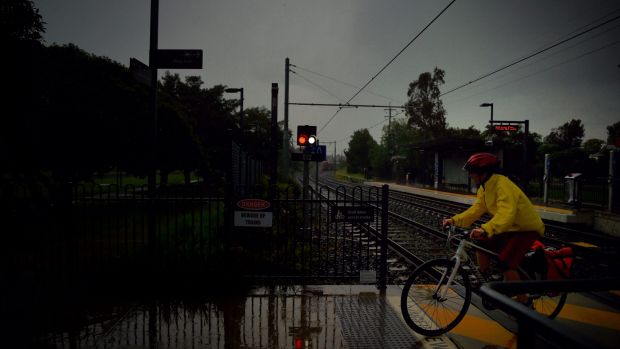
As "severe weather conditions" hit the city, commuters were advised to expect delays for their journey home. Sydney Trains cancelled several planned services on the North Shore line and Western Line, from Central to Hornsby and Blacktown, and commuters were told to expect delays with others.
Hey #Sydney CBD this storm is heading your way. V windy. 5 min ago in Glendenning. @WeathermanABC #SydneyStorm @abcsydney @rgloveroz @smh pic.twitter.com/oPQeC1LAiI
— Dan (@Dan_M75) March 22, 2017
On the Central Coast and Newcastle train line, there were "major delays" due to "urgent signal equipment repairs caused by severe weather conditions".
Ferries between Parramatta and Rydalmere were replaced by buses, as Parramatta Weir overflowed.
Drivers were also advised to take care, as multiple sets of traffic lights were blacked out in western Sydney and a tree fell onto a car at Mulgoa Road in Mulgoa at around 3.15pm.
Paramedics responded, however the person trapped inside was not injured.
Team Effort: #Paramedics @NSWSES @nswpolice @FRNSW working together at Mulgoa this afternoon to help after #SydneyStorm Be safe! pic.twitter.com/q03GUD0VUU
— NSW Ambulance (@NSWAmbulance) March 22, 2017
The storms also lashed the Central Coast, impacting Patonga, Woy Woy, Umina and Kilcare and moving towards the north-east.
Suburbs including Avoca Beach, Gosford, Terrigal, Erina, Kariong, The Entrance, Tuggerah Lake, Tuggerah, Berkeley Vale and Bateau Bay were expected to be impacted by 6.10pm.
The Bureau of Meteorology said "damaging winds, heavy rainfall that may lead to flash flooding and large hailstones are likely" for the region.
Ausgrid said about 2700 homes and businesses were left without power in the region.
Tuesday's storms dumped about 25 millimetres of rain on Observatory Hill, with some regions such as Richmond collecting more than 40 millimetres.
Flights in and out of Sydney Airport could be affected by the latest deluge, with the airport advising people to contact their airlines for updates on schedules.
😬☔️ pic.twitter.com/re1FwWEVZ5
— Sydney Airport ✈️ (@SydneyAirport) March 22, 2017
Other areas in the state affected by storm warnings include Nowra, Bowral, Orange, Mudgee, Bathurst, Katoomba, Goulburn, Yass, Dubbo, Parkes, Wellington and Condobolin.
A southerly change is expected to arrive late on Wednesday afternoon, providing additional lift for the moist air mass over the region.
The thunderstorms could last well into the evening and potentially extend into the early hours of Thursday, Ms Kamitakahara said.
Little time lapse of #SydneyStorm from North Bondi. pic.twitter.com/B4KITcDiYM
— Siobhan Heanue (@siobhanheanue) March 22, 2017
The good news, though, is that from Thursday onwards conditions should start to dry off, with only a few showers forecast by the bureau for the coming week.
The bureau has collected at least 0.2 millimetres of rain at Observatory Hill on all but four days so far this month.
The record number of days with some rain in Sydney in March is 26 days, recorded back in 1870.
The arrival of the cool change will lower temperatures a couple of degrees for coming days after Sydney reached 30 degrees for the first time this month.
Despite the lack of particularly hot days of late - unlike Sydney's record hot summer - March is well on course to be yet another warmer-than-average month for the city.

WIth Georgina Mitchell