
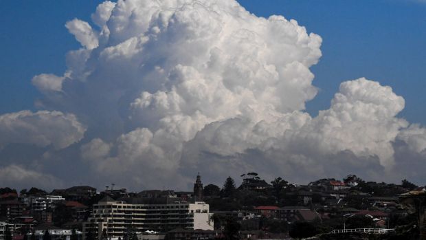
Sydney faces another day of thunderstorm activity as storms continue over inland regions and rains become more persistent.
The Bureau of Meteorology predicts Sydney's rainfall on Tuesday to range from 25-45 millimetres, with "a thunderstorm likely, possibly severe", with heavy falls possible.
The bureau has issued a warning for severe thunderstorms for the Sydney metropolitan area, north west slopes and plains, and parts of the Hunter, Illawarra, central tablelands, central west slopes and plains, upper western and northern tablelands districts. (See map below.)
More NSW News Videos

- Video duration
- 01:56
Sydney weather: Prepare for a wet Tuesday
Sydney weather: Prepare for a wet Tuesday
After heavy rain and hailstones on Monday, the wet weather will continue on Tuesday with potentially 10-20mm of rainfall for Sydney.
Up Next
Reading Kindle's terms and conditions

- Video duration
- 01:05

- Video duration
- 01:05
Reading Kindle's terms and conditions
Reading Kindle's terms and conditions
How long does it take to read Amazon Kindle's terms and conditions? CHOICE hired an actor to read all 73,198 words.
Up Next
Police track down fake Sydney doctor

- Video duration
- 00:30

- Video duration
- 00:30
Police track down fake Sydney doctor
Police track down fake Sydney doctor
NSW Police detectives have located a man in India who allegedly posed as a doctor at several Sydney hospitals for more than a decade. Vision courtesy Seven News.
Up Next
Sydney radio ratings

- Video duration
- 00:53

- Video duration
- 00:53
Sydney radio ratings
Sydney radio ratings
The numbers are in and there has been movement in the rankings across every category.
Up Next
Passengers injured in bus accident

- Video duration
- 00:22

- Video duration
- 00:22
Passengers injured in bus accident
Passengers injured in bus accident
At least 9 people, including the driver have been injured after a bus crashed into a garbage truck in Wetherill Park in Sydneyâs west.
Up Next
Young boy, woman's body found

- Video duration
- 00:13

- Video duration
- 00:13
Young boy, woman's body found
Young boy, woman's body found
A crime scene has been established at a unit in Sydney's Hillsdale suburb, after a woman and child were found dead inside the home. Vision: Nine News Sydney
Up Next
Students welcome multiculturalism

- Video duration
- 00:40

- Video duration
- 00:40
Students welcome multiculturalism
Students welcome multiculturalism
Evans High School students celebrate their diversity, where more than half of the student body speaks a language other than English. Vision: Peter Rae.
Sydney weather: Prepare for a wet Tuesday
After heavy rain and hailstones on Monday, the wet weather will continue on Tuesday with potentially 10-20mm of rainfall for Sydney.
"Severe thunderstorms are likely to produce heavy rainfall that may lead to flash flooding over the next several hours in the [Sydney] metropolitan and parts of the Hunter, Illawarra and Central Tablelands districts," the bureau said in its 12.25 pm update.
Locations which may be affected include Newcastle, Gosford, Sydney, Penrith, Parramatta and Katoomba.

Rainfall totals of note in the Sydney area include almost 40 millimetres at Horsley Park, and 28 mm at Penrith. Mt Boyce has had about 60 mm since midnight, half of which fell in about half an hour after 9.30 am.
Meanwhile, for the northern region of the state the risk from the forecast severe thunderstorms includes large hailstones and heavy rain.
Locations which may be affected include Gunnedah, Moree, Narrabri, Walgett, Coonamble, Coonabarabran and Lightning Ridge, the bureau said.

As on Monday, the storms are more likely in the city's west, such as the foothills of the Blue Mountains, with "the coastline less of a chance", Jordan Notara, a bureau forecaster, said.
Showers are likely to be frequent in Sydney during the day, with storms bringing higher totals to affected suburbs.

A slow-moving high pressure system in the Tasman is directing an easterly flow of moist air. Cold upper level air is providing the ingredient necessary to promote storm activity.
On Monday, the city dodged most of the storm activity along regions to the north, such as Gosford, and Katoomba in the Blue Mountains were not so lucky.
Still, Baulkham Hills collected about 25 mm of rain and Hornsby 20 mm, while parts of the southern highlands received 60 mm, Mr Notara said.
One of Monday's more active storm cells dumped about 50 millimetres on the town of Dubbo in the state's central west in three hours, or almost a month's worth of rain. Its tally of almost 70 mm for the day appears to be a March daily record for the town, Jacob Cronje, a senior meteorologist at Weatherzone, said.
A lightning strike was recorded within about five kilometres of Sydney Airport but most of Monday's storm activity was to the west of the ranges, he said.
Wednesday will also be wet, with another 10-20 mm forecast and showers likely for each day until early next week.
"Showers are really lingering across the eastern seaboard into the weekend," Mr Cronje said.
Temperatures are also stuck in rut, with most days ranging from minimums of about 20 degrees to 26 degrees during the day, or slightly above the March average.
Mr Cronje said that with summer officially over, this past weekend's sunny and balmy conditions may be the best the city will see for some time, possibly until the next warming season gets underway.
Storm chasers were out in force in various parts of the state hoping to catch a tempest or perhaps even a tornado.
"The indices and metrics that we use to forecast tornadoes are suggesting they are possible [in] the North West Slopes and Plains," Graeme Brittain, a meteorologist with Weatherzone, said on Monday.
Weatherzone: Sydney radar

Weatherzone is owned by Fairfax Media, publisher of this website.