Western Australia is in for one of those crazy weekends of mixed-up weather.
In the Perth metropolitan area we are expecting hot and humid weather with tops close to 40 degrees.
At the same time The Department of Fire and Emergency Services has issued a flood warning for parts of the Kimberley AND bushfire warnings for the Pilbara and Goldfields.
Meanwhile a group of amateur weather watchers has produced some cyclone modelling which has caused a few raised eyebrows.

The official Bureau of Meteorology forecasts that Perth will hit a high of 38 on Saturday, 39 on Sunday and back to 38 again for Monday.
"Very hot and mostly sunny with the chance of a shower or thunderstorm," on both Sunday and Monday says the BOM.
Meanwhile people in the Kimberley are preparing for floods along the Ord River, Keep River, King River, Fitzroy River, Pentecost River and Drysdale River catchments.
The DFES has advised locals to take precautions.
"Prepare to relocate equipment and livestock early so they are not caught in floodwaters. Prepare an emergency kit including enough canned food and water to last for four days, as well as clothing, important documents and medication," says the DFES.
Meanwhile the Department has issued bushfire advice for the Shires of Ashburton and Coolgardie.
In both cases the warning says that there is not threat to lives or home but that there is a lot of smoke in the area.
In Fortescue the fire started near North West Coastal Highway and Panawonica Road.
"It is contained but not controlled and is moving slowly in a west south westerly direction," says the alert.
In Boorabin the fire is located north of Great Eastern Highway. It is moving slowly in a south westerly direction.
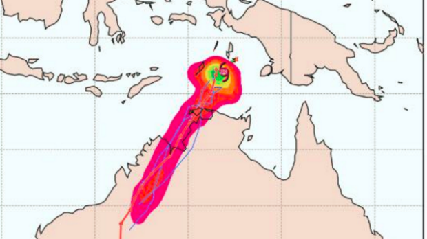
But perhaps the most startling weather image of the day appears to come from a group called Oz Cyclone Chasers.
They, apparently, produced a map showing a large penis-shaped cyclone moving from the Northern Territory into Western Australia.
Printed by the Northern Territory online news service, the map caused a sensation on social media.
One comment, from Darryl Haggerty, didn't see the joke.
"I don't know where they got that tracking map from but it's definitely not right," he wrote.
"Look at the bom forecast tracking map and others; none of them have it tracking this way."
Others replied, "Oz cyclone chasers' modelling, they are just d**king with ya Darryl!"