 Yesterday I posted a quick summary of the NSW government’s council amalgamation announcement.
Today I wanted to run through the partisan impact of the councils being created, and the impacts on the next NSW council elections.
In December, I assessed the proposed council amalgamations by calculating the federal two-party-preferred vote in each area.
There is a lot of variation in council elections – strong independents can mask the political bent of an area, and in some areas major parties don’t contest the election. While there is some personal vote effects in federal election results, I thought using the 2013 election would be useful in estimating the underlying political trend of each area. Basically I estimated the 2013 Coalition two-party-preferred vote in each council and then subtracted 3.5% from that figure to get a figure which would produce a statewide 50/50 result.
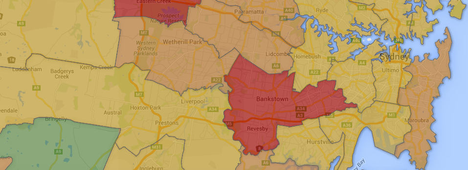
Some of the trends we saw in the draft proposals can be seen in the final decisions announced yesterday:
- The new Parramatta is more Liberal-leaning than the old Parramatta, while neighbouring Cumberland is strongly Labor-leaning.
- Pro-Labor Randwick has been absorbed into an overall Liberal-leaning eastern suburbs council.
- Including Botany Bay in the eastern suburbs and Rockdale in Georges River would have made both councils more Labor-friendly. Instead a bizarre council has been created in the middle.
- Greater Ryde (as I’ve called it – no name has been released as the decision is pending court action) is substantially more friendly to the Liberal Party than the old Ryde, which was more of a marginal council.
Kiama, which was expected to be absorbed by the larger and more conservative Shoalhaven council, has been spared.
I’ve updated the map to include the rest of the state – a series of new councils have been created in south-western and south-eastern NSW, and the three big towns in central west NSW, Dubbo, Orange and Bathurst, have been brought into bigger regional councils.
Now I want to address the major democratic deficit in yesterday’s announcement.
I’m not going to go over the whole question of whether council amalgamations are a good idea in this form, or whether bigger councils are better or worst, but instead address how the ward boundaries have been drawn, and the absurdly long period that so much of New South Wales will go without elected representatives.
It’s very unclear when elections will be held for most NSW councils. My best guess at the moment is that there will be three council election dates in 2016-17:
- Councils unaffected by mergers (eg. Blacktown, Fairfield) – September 2016
- Councils which were considered for amalgamation but were spared (eg. Hawkesbury, Kiama) – March 2017
- New councils – September 2017
It’s also unclear how soon amalgamations will happen in the case of councils where the minister has given “in principle” support for amalgamations pending court action, or for those where no decision has been made (eg. Newcastle/Port Stephens). Will they be ready by September 2017, or will we have to wait longer?
It firstly seems ridiculous to scatter NSW council elections over such a long period.
More importantly, it’s an absurd amount of time to go without an elected council. I understand that you need some interregnum when replacing an outgoing council with a merged council, but fifteen months is ridiculous.
About 27% of the NSW population lives in one of the nineteen new councils created yesterday. Another 21% lives in the nine proposed councils which will be created once the current court action is resolved. If Newcastle is also merged and its council sacked, that will be a majority of the NSW population living in an area with no elected local representation.
Finally, it is appalling the way that the state government has gone about drawing the ward boundaries for those new councils with wards.
If this were a federal or state election, the process of drawing electoral boundaries is delegated to an independent commission. That commission takes submissions, takes comments on those submissions, makes a draft map, and then takes objections and comments on those objections. If their second map is significantly different to the first map, they can sometimes provide a third round of objections.
In Victoria and Queensland, a centralised authority uses a similar process to draw up boundaries, with rounds for objections and comments.
We don’t get that in NSW. A referendum or ministerial approval is needed to change the number of councillors, create wards, abolish wards or change the mayoral election method, but the council itself can draw its own wards. Having said that, such a process is still open, with draft boundaries being put out for consultation before being decided by the council.
We got none of that for these new councils. There was some discussion about how many councillors each council should have, and whether there should be wards. But there was no hint that the wards would be decided unilaterally without any consultation at the same times as the councils were being created. The elections have been delayed by a year, there’s plenty of time to do it properly.
Having said that, we now know the wards for a bunch of new councils across Sydney. Once the federal election is over, I’ll move over to preparing ward maps for the upcoming Victorian and NSW council elections (all of them). Until then, this is my last post about this issue, and I’ll soon resume posting about the federal election.
 The NSW government has