

Synoptic
Saturday
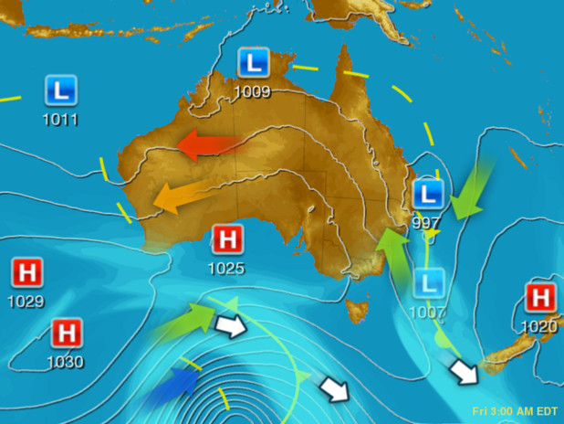
A monsoon trough and embedded tropical low is causing heavy rain and storms in the tropics, particularly in the Gulf of Carpentaria. Troughs in the east and west are causing storms. A cold front over VIC and TAS is bringing gusty showers.
Issued Saturday 05:10 EDT
Saturday - Latest
A monsoon trough and embedded tropical low is causing heavy rain and storms in the tropics, particularly in the Gulf of Carpentaria. Troughs in the east and west are causing storms. A cold front over VIC and TAS is bringing gusty showers.

Saturday 22:00 EDT
A potential tropical cyclone will generate heavy rain, damaging winds and storms about the Gulf of Carpentaria. A trough over central/eastern parts will trigger showers and thunderstorms. A low to the south and onshore winds should bring isolated showers to TAS, VIC and NSW.

Sunday 22:00 EDT
A potential tropical cyclone will generate heavy rain, damaging winds and storms about the Gulf of Carpentaria. A trough to the east will bring rain and storms to QLD and NSW. A trough in the west will bring isolated showers and the odd storm to WA.

Monday 22:00 EDT
A potential tropical cyclone shall generate heavy rain, storms and gusty winds about the Gulf of Carpentaria. A trough in the west will produce some showers and storms over WA. A high to the south should bring clear skies to SA, VIC, NSW and most of TAS.

Tuesday 22:00 EDT
A potential tropical cyclone shall generate rain, storms and gusty winds about the Gulf of Carpentaria. A trough in the west should trigger a few showers and storms as it moves eastward. A high over the Tasman sea should keep the southeast warm and clear.

Wednesday 22:00 EDT
A monsoon trough and embedded low shall generate rain and storms over the Tropics, heaviest over QLD. A trough extending from WA to the southeast shall generate isolated shower and storms, with hot winds ahead of it. A cold front to the south could bring cool westerly winds.

Thursday 22:00 EDT
A monsoon trough across shall generate showers and storms over the topics, heaviest over northern QLD. A broad high pressure system will keep conditions mostly dry over southern WA, SA, VIC, whilst directing showers over western TAS, and coastal VIC and NSW.
Based on information from the
Bureau of Meteorology and other providers
Sponsored Links
Herald Sun Synoptic charts below provide isobar, rainfall probability and wind stream direction probability for the Melbourne area and across Australia. The maps show the chronological weather pattern change at 10pm each day for the next 7 days.