BOM says Queensland may see first cyclone of season, to be named Alfred
Updated
There is a high chance a cyclone will form in Queensland's Gulf of Carpentaria tonight, the Bureau of Meteorology (BOM) has warned.
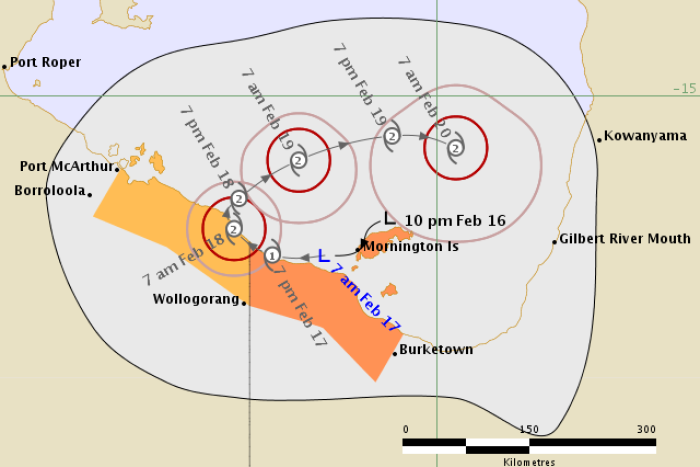
A tropical low was moving over Mornington Island early on Friday morning, with wind gusts of up to 95 kilometres per hour hitting the community.
Isolated falls up to 300mm were also possible.
The low is expected to continue moving south-west towards the Northern Territory border, where it has a more than 50 per cent chance of turning into a category one cyclone by about 7:00pm.
The chance of forming would be highly dependent on the system taking a track over water during the next 24 hours.
"It would be the first cyclone of the season," BOM forecaster Janine Yusa said.
"If it develops it will be called Alfred."
The possible cyclone is then forecast to boomerang back from the NT towards Mornington Island again.
There is a chance it could strengthen into a category two system by Saturday.
The warning zone for the tropical low stretches from the Northern Territory border to Burketown.
Gulf communities were being told to prepare for winds of more than 125kph, heavy rain and large waves.
"Today, the Gulf coast could get 50mm to 100mm quite easily, isolated heavy falls of up to 300mm or more over the islands," Ms Yusa said.
"Over the weekend, some of that rain could move inland to places like Doomadgee and Burketown."
Topics: weather, cyclones, disasters-and-accidents, cairns-4870, qld, darwin-0800, nt
First posted


